Suk Samran District
Suk Samran (Thai: สุขสำราญ, pronounced [sùk sǎm.rāːn]) is a district (amphoe) of Ranong Province, southern Thailand.
Suk Samran สุขสำราญ | |
|---|---|
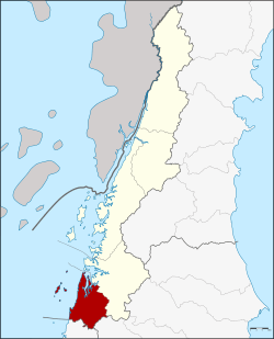 District location in Ranong Province | |
| Coordinates: 9°20′41″N 98°25′46″E | |
| Country | Thailand |
| Province | Ranong |
| Seat | Kamphuan |
| Area | |
| • Total | 395.087 km2 (152.544 sq mi) |
| Population (2005) | |
| • Total | 11,046 |
| • Density | 28.0/km2 (73/sq mi) |
| Time zone | UTC+7 (ICT) |
| Postal code | 85120 |
| Geocode | 8505 |
History
The district was created on 1 April 1992 by splitting off the southern part of Kapoe District.[1] On 15 May 2007, all 81 minor districts were upgraded to full districts.[2] On 24 August the upgrade became official .[3]
Geography
Neighboring districts are (from the north clockwise) Kapoe of Ranong Province, Ban Ta Khun of Surat Thani Province, and Khura Buri of Phang Nga Province. To the west is the Andaman Sea.
The eastern half of the district is part of the Khlong Nakha Wildlife Sanctuary.
Administration
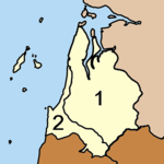
The district is divided into two sub-districts (tambons), which are further subdivided into 13 villages (muban). There are no municipal (thesaban) areas, and two tambon administrative organizations (TAO).
|
 |
References
- ประกาศกระทรวงมหาดไทย เรื่อง แบ่งเขตท้องที่อำเภอกะเปอร์ จังหวัดระนอง ตั้งเป็นกิ่งอำเภอสุขสำราญ (PDF). Royal Gazette (in Thai). 109 (53 ง): 20. April 22, 1992.
- แถลงผลการประชุม ครม. ประจำวันที่ 15 พ.ค. 2550 (in Thai). Manager Online. Archived from the original on 2011-05-16.
- พระราชกฤษฎีกาตั้งอำเภอฆ้องชัย...และอำเภอเหล่าเสือโก้ก พ.ศ. ๒๕๕๐ (PDF). Royal Gazette (in Thai). 124 (46 ก): 14–21. August 24, 2007.