Stylida
Stylida (Greek: Στυλίδα; older Στυλίς, Stylis) is a town and a municipality in Phthiotis, Greece. The population of the municipal unit was 6,126 (2011).
Stylida Στυλίδα | |
|---|---|
 | |
 Stylida Location within the region 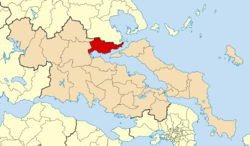 | |
| Coordinates: 38°55′N 22°37′E | |
| Country | Greece |
| Administrative region | Central Greece |
| Regional unit | Phthiotis |
| Government | |
| • Mayor | Virginia Stergiou |
| Area | |
| • Municipality | 463.9 km2 (179.1 sq mi) |
| • Municipal unit | 202.5 km2 (78.2 sq mi) |
| Population (2011)[1] | |
| • Municipality | 12,750 |
| • Municipality density | 27/km2 (71/sq mi) |
| • Municipal unit | 6,126 |
| • Municipal unit density | 30/km2 (78/sq mi) |
| Community | |
| • Population | 5,011 (2011) |
| Time zone | UTC+2 (EET) |
| • Summer (DST) | UTC+3 (EEST) |
| Vehicle registration | ΜΙ |
| Website | http://www.stylida.gr |
History
First mention of the town of Stylida was during ancient times when the town was named Phalara (Ancient Greek: Φάλαρα). The town has many ancient buildings and artifacts, such as the wall near the church of Agia Ekaterini, the tombs located near Karkali street and a mosaic under the Eleftheriou Venizelou street.
Municipality
The municipality Stylida was formed at the 2011 local government reform by the merger of the following 3 former municipalities, that became municipal units:[2]
The municipality has an area of 463.863 km2, the municipal unit 202.477 km2.[3]
Geography
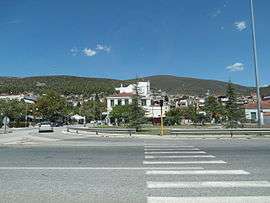
The port town Stylida is situated on the northern shore of the Malian Gulf, and at the southern foot of Mount Othrys, It is 17 km east of Lamia, the capital of Phthiotis. The Greek National Road 1 passes through the town.
Twin towns

External links
- Municipality of Stylida (in Greek and English)
References
- "Απογραφή Πληθυσμού - Κατοικιών 2011. ΜΟΝΙΜΟΣ Πληθυσμός" (in Greek). Hellenic Statistical Authority.
- Kallikratis law Greece Ministry of Interior (in Greek)
- "Population & housing census 2001 (incl. area and average elevation)" (PDF) (in Greek). National Statistical Service of Greece.
Administrative division of the Central Greece Region | ||
|---|---|---|
| Regional unit of Boeotia | 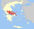 | |
| Regional unit of Euboea | ||
| Regional unit of Evrytania | ||
| Regional unit of Phocis | ||
| Regional unit of Phthiotis | ||
| ||