Stranadarragh
Stranadarragh (from Irish: Srath na Darach, meaning "The River-Meadow of the Oaktree") is a townland in the civil parish of Templeport, County Cavan, Ireland. It lies in the Roman Catholic parish of Templeport and barony of Tullyhaw.
Geography
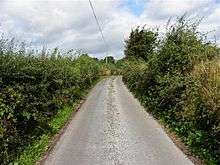
Stranadarragh is bounded on the north by Drumlougher townland, on the west by Bellaleenan and Ballymagirril townlands, on the south by Cornagunleog and Boley townlands and on the east by Owengallees townland. Its chief geographical features are the River Blackwater, County Cavan, marshes and dug wells. Stranadarragh is traversed by minor roads and rural lanes. The townland covers 155 statute acres.[1]
History
Until the late 18th century, the modern townland of Cornagunleog formed part of Stranadarragh.
The 1652 Commonwealth Survey spells the name as Srahnedaragh. The 1665 Down Survey map depicts it as Shanderagh.[2] William Petty's 1685 map depicts it as Shanderagh.[3]
The 1652 Commonwealth Survey lists the proprietor as Lieutenant-Colonel Tristram Beresford, who also appears as proprietor of other townlands in the survey. In the Hearth Money Rolls of 1662 there were no taxpayers paying the Hearth Tax in Stranadarragh.
A grant dated 3 November 1666 was made by King Charles II of England to Sir Tristram Beresford, 1st Baronet which included, inter alia, the lands of Shranadanagh. By grant dated 11 September 1670 from King Charles II of England to said Sir Tristram Beresford, the said lands of Shranadanagh were included in the creation of a new Manor of Beresford.
The 1790 Cavan Carvaghs list spells the townland name as Sranedaragh.[4]
Lowther Kirkwood of Mullinagrave, parish of Templeport, Co. Cavan, gentleman made the following will:
2 July 1804. To his grandnephew Lowther Brien, city of Dublin, attorney, and his heirs his lands of Awengallis, Ballylenan, Ballymagirill, Stranadarragh, Carnagimlie, Cullagh, Drumleden, Leitry [Leitra], Corlagh, Lananleragh [Lannanerriagh], Gowlanlea and Drumlogher, Co. Cavan, held under lease from the Beresford family. He had begun a suit in Chancery, Ireland, against John Brien, late of Salvon, Co. Fermanagh, deceased, for setting aside a fradulent deed obtained by said John Brien, which suit against the representatives is to be continued by said Lowther Brien, his sole exor. Witnesses: John Johnston and Andrew Rutledge, both of Ballymagiril, and Thos. Stephenson, Drumleaden, Co. Cavan, gent. Memorial witnessed by: said Andrew Rutledge, and John Balfour, city of Dublin, attorney.[5]
The Tithe Applotment Books for 1827 list eleven tithepayers in the townland.[6][7][8]
The Stranadarragh Valuation Office Field books are available for October 1839.[9][10]
Griffith's Valuation of 1857 lists seventeen landholders in the townland.[11]
On 6 July 1857 the Incumbered Estates Commission published the following notice:[12]
In the Matter of the Estate of James Brien, Geo. Brien, Edward Brien and Francis Brien, Owners. Exparte by Isabella Crummer, Petitioner. The commissioners having ordered a Sale of the Lands of Shanadaragh and Curnagunlogh, Cullegh, Drumlohgher, Drumledin, Sananaragh, and Drumledin, and Corlough, situate in the Barony of Tullyhaw, and County of Cavan, held under lease dated the 10th April, 1718, from the Bishop Raphoe, for lives renewable for ever, and which Lands are included in the denominations of Ballymagord, Owngally, Gortneglough, Drumedin or Ballylennin, in said lease mentioned:
Census
| Year | Population | Males | Females | Total Houses | Uninhabited |
|---|---|---|---|---|---|
| 1841 | 77 | 45 | 32 | 11 | 0 |
| 1851 | 58 | 28 | 30 | 10 | 0 |
| 1861 | 70 | 35 | 35 | 12 | 0 |
| 1871 | 45 | 21 | 24 | 9 | 0 |
| 1881 | 36 | 18 | 18 | 8 | 0 |
| 1891 | 40 | 20 | 20 | 8 | 0 |
In the 1901 census of Ireland, there are ten families listed in the townland, [13] and in the 1911 census of Ireland, there are only eight families listed in the townland.[14]
Antiquities
References
- "IreAtlas". Retrieved 29 February 2012.
- Trinity College Dublin: The Down Survey of Ireland.
- "Down Survey Maps | The Down Survey Project". downsurvey.tcd.ie.
- Registry of Deeds (Ireland); Eustace, P.B.; Ellis, E.; Irish Manuscripts Commission (1984). Abstracts of Wills: 1785-1832. Stationery Office. Retrieved 16 April 2016.
- "The Tithe Applotment Books, 1823-37". titheapplotmentbooks.nationalarchives.ie. Retrieved 16 April 2016.
- "The Tithe Applotment Books, 1823-37". titheapplotmentbooks.nationalarchives.ie. Retrieved 16 April 2016.
- "The Tithe Applotment Books, 1823-37". titheapplotmentbooks.nationalarchives.ie. Retrieved 16 April 2016.
- "Griffith's Valuation". askaboutireland.ie. Retrieved 16 April 2016.
- "Co. Cavan; Ireland Newspaper Abstracts".
- "National Archives: Census of Ireland 1901". census.nationalarchives.ie. Retrieved 16 April 2016.
- "National Archives: Census of Ireland 1911". census.nationalarchives.ie. Retrieved 16 April 2016.
- Site number 1116 in "Archaeological Inventory of County Cavan", Patrick O'Donovan, 1995, where it is described as- Raised oval area (int. dims. 37.3m N-S; 31.1m) enclosed by a substantial earthen bank and a wide, deep, partly waterlogged fosse. An earlier report (OPW 1969) suggested that the original entrance was probably at SE.
- Site number 1117 in "Archaeological Inventory of County Cavan", Patrick O'Donovan, 1995, where it is described as- Raised circular area (int. diam. 32.4m) enclosed by a substantial earthen bank and a shallow fosse identifiable only from SSE-S-W. Both bank and fosse have been destroyed from NNW-N-NE as a consequence of road construction. A stream flows through a narrow channel at the external foot of the bank from ENE-E-SSE and a modern pump-house has been erected at E. An earlier report (OPW 1969) suggested that the original entrance was probably at E.
External links
Places in County Cavan | ||
|---|---|---|
| Towns |  | |
| Villages |
| |
| Townlands | ||
| ||