Stegaurach
Stegaurach is a community in the Upper Franconian district of Bamberg and the seat of the administrative community (Verwaltungsgemeinschaft) of Stegaurach.
Stegaurach | |
|---|---|
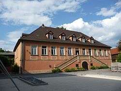 Böttinger Manor | |
 Coat of arms | |
Location of Stegaurach within Bamberg district 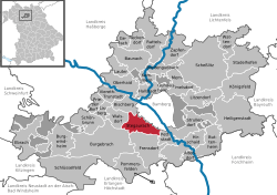 | |
 Stegaurach  Stegaurach | |
| Coordinates: 49°52′12″N 10°46′56″E | |
| Country | Germany |
| State | Bavaria |
| Admin. region | Oberfranken |
| District | Bamberg |
| Municipal assoc. | Stegaurach |
| Subdivisions | 11 Ortsteile |
| Government | |
| • Mayor | Thilo Wagner (FW) |
| Area | |
| • Total | 23.89 km2 (9.22 sq mi) |
| Elevation | 268 m (879 ft) |
| Population (2018-12-31)[1] | |
| • Total | 7,064 |
| • Density | 300/km2 (770/sq mi) |
| Time zone | CET/CEST (UTC+1/+2) |
| Postal codes | 96135 |
| Dialling codes | 0951 |
| Vehicle registration | BA |
| Website | www.stegaurach.de |
Geography
The community of Stegaurach lies in the valley of the Aurach, about 4 km west of Bamberg. Stegaurach lies in the Upper Franconia-West region.
Constituent communities
Stegaurach’s main and namesake centre is by far the biggest of its Ortsteile with a population of 4,033. The community furthermore has these outlying centres, each given here with its own population figure and dialectal name where there is one:
- Debring (village) 484
- Dellerhof (farm) 17
- Dellern (farm) 32
- Hartlanden (village) 410, locally “Hädländ”
- Höfen (village) 220, locally “Höfn”
- Kaifeck (hamlet) 12
- Knottenhof (small hamlet) 5, locally “Knonhof”
- Kreuzschuh (village) 210, locally “Kreutschi”
- Mühlendorf (village) 807, locally “Müllndäff”
- Mutzershof (hamlet) 67
- Seehöflein (village) 69
- Unteraurach (village) 256, locally “Ündäaurich”
- Waizendorf (village) 505, locally “Waizndäff”
Stegaurach itself is known in the local speech as “Aurich”.
The community also has 5 traditional rural land units, known in German as Gemarkungen, named Hartlanden, Höfen, Mühlendorf, Stegaurach and Birkacher Wald, four of which (all but the last, which is a woodland) have the same names as four of the constituent communities (it is traditional for a Gemarkung to be named after a town or village lying nearby).
History
Stegaurach belonged to the High Monastery at Bamberg. Stegaurach was actually part of the hereditary estate administration, a great deal of which was nevertheless made up of the High Monastery’s property or its Mediaten. Since the Reichsdeputationshauptschluss of 1803, the community has belonged to Bavaria.
Population development
Within municipal limits, 3,935 inhabitants were counted in 1970, 4,958 in 1987 and 6,382 in 2000. In 2005 it was 6,747. In the next year the population figure climbed sharply, giving Stegaurach a population of 6,841 on 31 December 2006.
Politics
The mayor is Siegfried Stengel (CSU/Bürgerblock).
The community council is made up of 20 members, listed here by party or voter community affiliation, and also with the number of seats that each holds:
- CSU/Bürgerblock 10
- Freie Liste/ÜWG 4
- SPD 2
- Bürgernahe Liste 2
- GRÜNE-Bürgerst. 2
In 1999, municipal tax revenue, converted to euros, amounted to €2,573,000 of which business taxes (net) amounted to €263,000.
Economy and infrastructure
According to official statistics, there were no workers on the social welfare contribution rolls working in producing businesses or trade and transport. In other areas, 313 workers on the social welfare contribution rolls were employed, and 2,120 such workers worked from home. In processing businesses there were three businesses, and in construction 7. Furthermore, in 1999, there were 46 agricultural operations with a working area of 795 ha, of which 571 ha was cropland and 223 ha was meadowland.
Education
In 1999, the following institutions existed in Stegaurach:
- 225 kindergarten places with 228 children
- Elementary school with 25 teachers and 470 pupils
Town twinning

References
- "Fortschreibung des Bevölkerungsstandes". Bayerisches Landesamt für Statistik und Datenverarbeitung (in German). July 2019.
External links
| Authority control |
|
|---|