Stainton, Richmondshire
Stainton is a hamlet and civil parish in Swaledale in the Richmondshire district of North Yorkshire, England. It is located just outside the Yorkshire Dales National Park. The population of the parish was estimated at 10 in 2016.[1]
| Stainton | |
|---|---|
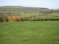 How Hill from near Stainton | |
 Stainton Location within North Yorkshire | |
| OS grid reference | SE105965 |
| Civil parish |
|
| District | |
| Shire county | |
| Region | |
| Country | England |
| Sovereign state | United Kingdom |
| Post town | Richmond |
| Postcode district | DL11 |
| Police | North Yorkshire |
| Fire | North Yorkshire |
| Ambulance | Yorkshire |
It lies close to the army training camp of Wathgill in the adjoining civil parish of Walburn. A large part of the parish consists of Ministry of Defence ranges and training areas.
Stainton was historically a township in the parish of Downholme in the wapentake of Hang West in the North Riding of Yorkshire.[2]
Walburn became a separate civil parish in 1866.[3] In 1974 it was transferred to the new county of North Yorkshire.
References
- "Population Estimates". North Yorkshire County Council. 2016. Retrieved 5 May 2020. At the 2011 Census the population was not counted separately.
- Page, William, ed. (1914). "Parishes: Downholme". Victoria County History. A History of the County of York North Riding: Volume 1. Institute of Historical Research. Retrieved 5 May 2020.
- Great Britain Historical GIS / University of Portsmouth, Stainton CP/Tn. Retrieved 5 May 2020.
This article is issued from Wikipedia. The text is licensed under Creative Commons - Attribution - Sharealike. Additional terms may apply for the media files.