Stahnsdorf
Stahnsdorf is a municipality in the Potsdam-Mittelmark district, in Brandenburg, Germany.
Stahnsdorf | |
|---|---|
 Stahnsdorf village church | |
 Coat of arms | |
Location of Stahnsdorf within Potsdam-Mittelmark district 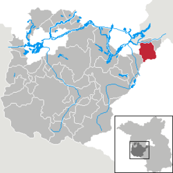 | |
 Stahnsdorf 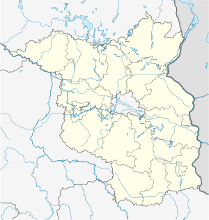 Stahnsdorf | |
| Coordinates: 52°23′32″N 13°13′00″E | |
| Country | Germany |
| State | Brandenburg |
| District | Potsdam-Mittelmark |
| Subdivisions | 4 Quarters |
| Government | |
| • Mayor | Bernd Albers (Ind.) |
| Area | |
| • Total | 49.07 km2 (18.95 sq mi) |
| Elevation | 44 m (144 ft) |
| Population (2018-12-31)[1] | |
| • Total | 15,243 |
| • Density | 310/km2 (800/sq mi) |
| Time zone | CET/CEST (UTC+1/+2) |
| Postal codes | 14532 |
| Dialling codes | 03329 |
| Vehicle registration | PM |
| Website | stahnsdorf.de |
Geography
It is situated on the Teltow plateau, about 20 km (12 mi) southwest of the Berlin city centre, and 12 km (7.5 mi) east of Potsdam. Neighbouring municipalities are the town of Teltow in the east and Kleinmachnow in the north, both immediately bordering the Berlin city limits.
The municipal area is bound by the Teltow Canal in the north. It comprises Stahnsdorf proper and the villages of Güterfelde, Schenkenhorst, and Sputendorf.
History
Stahnsdorf in the Margraviate of Brandenburg was first documented in a 1264 purchase contract of Margrave Otto III and the Brandenburg bishop. It originally consisted only of its old village green on a formerly important merchant road from Leipzig in Saxony via Güterfelde and Stahnsdorf, crossing the Bäke creek (the present-day Teltow Canal) at Kleinmachnow, and running northwards to Spandau.
With the construction of the Teltow Canal in the early 20th century, the opening of the large Southwest Cemetery in April 1909, the Wilmersdorfer Waldfriedhof and Friedenauer Waldfriedhof in 1913, and the opening of the S-Bahn route from Berlin-Wannsee station in June 1913 the development in a Berlin suburb began. In the following decades, the current site was created by the development of privately owned homes, the connection to Berlin-Lichterfelde by a tram and building a settlement for workers at the Bosch manufactures in Kleinmachnow.
In 1920 the Stahnsdorf Military Cemetery was formalised. It contains 1175 graves, mainly of British POWs who died in captivity.[2] It was designed by Sir Robert Lorimer.[3]
1931 Stahnsdorf WWTP was put into operation, where waste water from the south of Berlin was treated. It was one of the first plants to produce biogas.
The construction of the Berlin Wall on 13 August 1961 severed the connections to the bordering Berlin. In the communist era, the place was dominated economically, especially through the semiconductor business as a major operation and farms. The fall of the Berlin Wall set a renewing development by inflows, opening new home communities, and in recent years by commercial development, particularly in "Green Park", a large industrial park.
On 1 January 2002 Stahnsdorf in its present form was formed by the incorporation of the towns Güterfelde, Schenkenhorst and Sputendorf.
Demography
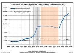 Development of population since 1875 within the current Boundaries (Blue Line: Population; Dotted Line: Comparison to Population development in Brandenburg state; Grey Background: Time of Nazi Germany; Red Background: Time of communist East Germany)
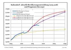 Recent Population Development and Projections (Population Development before Census 2011 (blue line); Recent Population Development according to the Census in Germany in 2011 (blue bordered line); Official projections for 2005-2030 (yellow line); for 2014-2030 (red line); for 2017-2030 (scarlet line)
| Stahnsdorf: Population development within the current boundaries (2017)[4] | |||||||||||||||||||||||||||||||||||||||||||||||||||||||||||||||||||||||||||||||||||||||||||||||||||||||||||||||||||||||||||||||||||||||||
|---|---|---|---|---|---|---|---|---|---|---|---|---|---|---|---|---|---|---|---|---|---|---|---|---|---|---|---|---|---|---|---|---|---|---|---|---|---|---|---|---|---|---|---|---|---|---|---|---|---|---|---|---|---|---|---|---|---|---|---|---|---|---|---|---|---|---|---|---|---|---|---|---|---|---|---|---|---|---|---|---|---|---|---|---|---|---|---|---|---|---|---|---|---|---|---|---|---|---|---|---|---|---|---|---|---|---|---|---|---|---|---|---|---|---|---|---|---|---|---|---|---|---|---|---|---|---|---|---|---|---|---|---|---|---|---|---|---|
|
|
| |||||||||||||||||||||||||||||||||||||||||||||||||||||||||||||||||||||||||||||||||||||||||||||||||||||||||||||||||||||||||||||||||||||||
Politics

Seats in the municipal assembly (Gemeindevertretung) as of 2014 local elections:
- Bürger für Bürger (Independent): 7
- Christian Democratic Union of Germany (CDU): 5
- Social Democratic Party of Germany (SPD): 3
- Wir Vier (Independent): 2
- Alliance '90/The Greens: 2
- The Left: 2
- Alternative for Germany (AfD): 1
References
- "Bevölkerung im Land Brandenburg nach amtsfreien Gemeinden, Ämtern und Gemeinden 31. Dezember 2018". Amt für Statistik Berlin-Brandenburg (in German). July 2019.
- https://www.cwgc.org/find-a-cemetery/cemetery/90900/berlin-south-western-cemetery/
- Dictionary of Scottish Architects: Robert Lorimer
- Detailed data sources are to be found in the Wikimedia Commons.Population Projection Brandenburg at Wikimedia Commons
External links
| Wikimedia Commons has media related to Stahnsdorf. |
- Official website of Stahnsdorf
- Stahnsdorf South-Western Cemetery
- Official website of the Stahnsdorf Voluntary Fire Department
Towns and municipalities in Potsdam-Mittelmark | ||
|---|---|---|
| Coat of Arms of Potsdam-Mittelmark district | |
| Authority control |
|
|---|