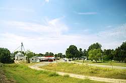
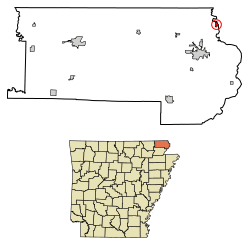
St. Francis, Arkansas
St. Francis is a city in Clay County, Arkansas, United States, along the St. Francis River. The population was 250 at the 2010 census.[3]
St. Francis, Arkansas | |
|---|---|
 St. Francis | |
 Location of St. Francis in Clay County, Arkansas. | |
| Coordinates: 36°27′13″N 90°8′36″W | |
| Country | United States |
| State | Arkansas |
| County | Clay |
| Area | |
| • Total | 0.37 sq mi (0.95 km2) |
| • Land | 0.37 sq mi (0.95 km2) |
| • Water | 0.00 sq mi (0.00 km2) |
| Elevation | 295 ft (90 m) |
| Population (2010) | |
| • Total | 250 |
| • Estimate (2017)[2] | 234 |
| • Density | 635.87/sq mi (245.21/km2) |
| Time zone | UTC-6 (Central (CST)) |
| • Summer (DST) | UTC-5 (CDT) |
| FIPS code | 05-61970 |
| GNIS feature ID | 0058569 |
History
The St. Francis area was settled in the 1840s, with the early residents forming the Chalk Bluff community just northwest of the present city. The Battle of Chalk Bluff was fought here in May 1863, during the Civil War. In 1882, the St. Louis Southwestern Railway ("Cotton Belt") was constructed through the area, and the Chalk Bluff community gradually shifted southeastward to a location along the railroad tracks. This new community was named "St. Francis" after the adjacent river (the river itself was named after Francis of Assisi).[4]
Geography
St. Francis is located at near the northeastern corner of Clay County 36°27′13″N 90°8′36″W (36.453583, -90.143251).[5] It is bordered on the east by the St. Francis River, which forms the Arkansas–Missouri state line. U.S. Route 62 passes through the community, leading south and west 7 miles (11 km) to Piggott, and northeast 4 miles (6 km) to Campbell, Missouri.
According to the United States Census Bureau, St. Francis has a total area of 0.37 square miles (0.95 km2), all land.[3]
Demographics
| Historical population | |||
|---|---|---|---|
| Census | Pop. | %± | |
| 1890 | 356 | — | |
| 1900 | 420 | 18.0% | |
| 1910 | 459 | 9.3% | |
| 1920 | 501 | 9.2% | |
| 1930 | 294 | −41.3% | |
| 1940 | 266 | −9.5% | |
| 1950 | 292 | 9.8% | |
| 1960 | 224 | −23.3% | |
| 1970 | 297 | 32.6% | |
| 1980 | 266 | −10.4% | |
| 1990 | 201 | −24.4% | |
| 2000 | 250 | 24.4% | |
| 2010 | 250 | 0.0% | |
| Est. 2017 | 234 | [2] | −6.4% |
| U.S. Decennial Census[6] | |||
As of the census[7] of 2000, there were 250 people, 103 households, and 70 families residing in the city. The population density was 837.1 people per square mile (321.8/km²). There were 125 housing units at an average density of 418.5/sq mi (160.9/km²). The racial makeup of the city was 96.80% White, 1.20% Native American, and 2.00% from two or more races. 0.40% of the population were Hispanic or Latino of any race.
There were 103 households out of which 34.0% had children under the age of 18 living with them, 55.3% were married couples living together, 10.7% had a female householder with no husband present, and 31.1% were non-families. 27.2% of all households were made up of individuals and 13.6% had someone living alone who was 65 years of age or older. The average household size was 2.43 and the average family size was 2.94.
In the city, the population was spread out with 25.6% under the age of 18, 12.0% from 18 to 24, 28.0% from 25 to 44, 21.6% from 45 to 64, and 12.8% who were 65 years of age or older. The median age was 33 years. For every 100 females, there were 95.3 males. For every 100 females age 18 and over, there were 91.8 males.
The median income for a household in the city was $30,278, and the median income for a family was $33,250. Males had a median income of $19,205 versus $13,563 for females. The per capita income for the city was $11,198. About 16.9% of families and 20.2% of the population were below the poverty line, including 25.0% of those under the age of eighteen and 38.2% of those sixty five or over.
See also
References
- "2017 U.S. Gazetteer Files". United States Census Bureau. Retrieved Aug 22, 2018.
- "Population and Housing Unit Estimates". Retrieved March 24, 2018.
- "Geographic Identifiers: 2010 Demographic Profile Data (G001): St. Francis city, Arkansas". U.S. Census Bureau, American Factfinder. Archived from the original on February 12, 2020. Retrieved June 16, 2014.
- Steven Teske, "St. Francis (Clay County)," Encyclopedia of Arkansas History and Culture, 2017.
- "US Gazetteer files: 2010, 2000, and 1990". United States Census Bureau. 2011-02-12. Retrieved 2011-04-23.
- "Census of Population and Housing". Census.gov. Retrieved June 4, 2015.
- "U.S. Census website". United States Census Bureau. Retrieved 2008-01-31.
External links

Municipalities and communities of Clay County, Arkansas, United States | ||
|---|---|---|
| Cities | 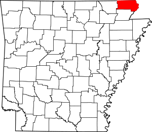 Map of Arkansas highlighting Clay County | |
| Towns | ||
| Unincorporated communities | ||
| Ghost town | ||
| Footnotes | ‡This populated place also has portions in an adjacent county or counties | |