Spring Creek (Sonoma County, California)
Spring Creek, in Sonoma County, California, is a 6.0-mile-long (9.7 km)[2] stream that rises in the northern part of the Sonoma Mountains[3] within Annadel State Park, draining the western slopes of Taylor Mountain and feeding into Matanzas Creek below the Matanzas Creek Reservoir.[4]
| Spring Creek | |
|---|---|
 Spring Creek streambed high in headwaters area | |
 Location of the mouth of Spring Creek in California | |
| Location | |
| Country | United States |
| State | California |
| Region | Sonoma County |
| City | Santa Rosa, California |
| Physical characteristics | |
| Source | Bennett Mountain |
| • location | Annadel State Park |
| • coordinates | 38°25′18″N 122°36′46″W[1] |
| • elevation | 1,220 ft (370 m) |
| Mouth | Matanzas Creek |
• location | west end of Doyle Park in Santa Rosa, California |
• coordinates | 38°26′21″N 122°42′1″W[1] |
• elevation | 164 ft (50 m)[1] |
The waters of Spring Creek ultimately reach the Pacific Ocean just south of Jenner, California, by way of Matanzas Creek, Santa Rosa Creek, the Laguna de Santa Rosa, Mark West Creek, and the Russian River.
Gallery
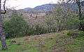 Spring Creek watershed of headwaters area.
References
- U.S. Geological Survey Geographic Names Information System: Spring Creek
- U.S. Geological Survey. National Hydrography Dataset high-resolution flowline data. The National Map, accessed March 9, 2011
- Santa Rosa Quadrangle, Fifteen minute series, USGS Quadrangle Map, U.S. Government Printing Office, Washington DC (1958)
- C.Michael Hogan, John Torrey, Brian McElroy et al., Environmental Impact Report, Southeast Santa Rosa Annexation 2-88, Earth Metrics Inc., Report 7941, California State Clearinghouse, Sacramento, Ca., March 1990
See also
- Lake Ralphine
- List of watercourses in the San Francisco Bay Area
- Pomo people
- Spring Lake Regional Park
This article is issued from Wikipedia. The text is licensed under Creative Commons - Attribution - Sharealike. Additional terms may apply for the media files.