Spiral bridge
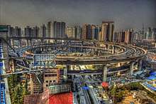
A spiral bridge, loop bridge, or pigtail bridge is a road bridge which loops over its own road, allowing the road to climb rapidly. This is useful in steep terrain, or where the approach road to a bridge would terminate too far from the bridge's end. The shape of the bridge forms a helix, not a spiral.

Many multi-storey car parks feature such a design as this.
Pigtail bridge

In the Black Hills of South Dakota, a particular form of spiral bridge, locally called a 'pigtail bridge', was introduced in 1932 by Cecil Clyde Gideon, the self-taught superintendent of Custer State Park turned highway designer. He called them “spiral-jumpoffs”. During the planning for Iron Mountain Road, there was a need to negotiate sudden elevation drops while preserving natural features for this scenic highway; the corkscrew design allowed for a spectacular—albeit expensive—solution to this problem. In order to blend the bridges with their surroundings, natural materials such as local timber were used.
Most pigtail bridges were built by the Civilian Conservation Corps in the 1930s.
List of spiral road bridges
| Name | Location | Year | Comment |
|---|---|---|---|
| Spiral Bridge at Hastings High Bridge | 1895-1951 | ||
| South Dakota Highway 87 in Wind Cave National Park | |||
| Steinmen Crossing on Oregon Highway 273, part of Historical U.S. Highway 99 through the Siskiyou Mountains. | |||
| A bridge on US Route 441 between Gatlinburg, Tennessee and Cherokee, North Carolina at Bearpen Hollow in the Great Smoky Mountains National Park | |||
| Three bridges on Iron Mountain Road | 1930s | ||
| Lincoln Tunnel approach road to west portal. | |||
| Astoria–Megler Bridge south approach. | |||
| Zuidweg Bridge | 52.047468°N 4.475218°E | ||
| General Artigas Bridge | From Colón, Entre Ríos, Argentina to Paysandú, Paysandú Department, Uruguay, across the Uruguay river. Cantilever bridge with a spiral on the Uruguay side. | ||
| Wiadukt Stanisława Markiewicza | 1904 | In Ulica Karowa which connects Krakowskie Przedmiescie to river level, | |
| A-7000 (previously C-345) | 2 spiral tunnels at 36.775796°N 4.379339°W | ||
| Thames Tunnel (planned, not constructed) | 1825-1843 | Originally planned to have an underground spiral giving access to road traffic, but this was never built.[2] | |
| Route de Cilaos | 21.181180°S 55.454704°E | ||
| Sa Calobra | 39.831968°N 2.81574°E | ||
| N8 Bypass Brienzwiler | 46.750521°N 8.108833°E | ||
| Isenfluh | |||
| A6 Highway | 44.320409°N 8.377118°E | ||
| SP99 just north of Bolzano | |||
| on the climb of Mount Parnassos to Delphi, Greece. 270° spiral using an overpass. | |||
| S232 Bridge South Approach | 31.715834°N 120.068168°E | ||
| Weidun Road Bridge | 31.722803°N 120.059752°E | ||
| Caiyuanba Bridge South Approach | 29.5360605°N 106.551513°E | ||
| Rongqiao Road Spiral Bridge | Triple Loop Bridge 29.5262731°N 106.5449174°E | ||
| Jialing Jiahua Bridge Approach | 29.5606004°N 106.5174331°E | ||
| Zhoutouju Tunnel Approach | 23.0985181°N 113.2520531°E | ||
| New Clear Water Bay Road | 22.331717°N 114.224617°E | ||
| Yanbai Yellow River Bridge North Approach | 36.0789724°N 103.8814573°E | ||
| Nanpu Bridge Puxi Approach | 2004 | ||
| G329 South Bridge Approach | 30.0218999°N 120.7308062°E | ||
| Huanggang Port Approach | |||
| Jinchang Road Bridge | Double loop bridge on each approach 31.556633°N 120.330889°E | ||
| Sendonmatsuo Bridge Approaches | Double loop bridge on each approach 34.6324803°N 135.4759645°E | ||
| Shinkizugawao Bridge North Approach | 34.62866°N 135.4623977°E | ||
| Prefectural Road 53 Onawaba Bridge east approach | 35.423410°N 136.744817°E | ||
| Kawazu-Nanadaru Loop Bridge | 1981 | Double loop bridge. 34.791°N 138.938°E | |
| Mizukami Loop Bridge | 32.315°N 131.01°E | ||
| Yurikamome approach to Rainbow Bridge | From the mainland. | ||
| Cahill Expressway | Spiral turns left in order to turn right. |
Spiral pedestrian bridges
- 1998–2004, Glass Spiral Bridge, Millennium Place, Coventry, England
Turnover bridges
Turnover bridges were a feature of some early British canals such as the Macclesfield. The boats were pulled by a horse, and in locations where the towpath crossed to the opposite bank, the spiral on one side allowed the horse to continue without detaching the tow rope. They were not universally provided as they were more expensive to build, needing to span both the canal and the towpath.
References
- "Google Maps". Google Maps.
- J.W. Parker, The roads and railroads, vehicles, and modes of travelling, of ancient and modern countries, p. 154
Further reading
- Bernie Hunhoff, The Man Who Designed the Pigtails, South Dakota Magazine, 27 July 2006,
- Jim Pisarowicz, Pigtail Bridge, Wind Cave National Park, National Park Service
- Brochure, Welcome to the Peter Norbeck Scenic Byway, United States Forest Service
- Missouri River Bridges of South Dakota, 1920 to 1980, interview of Kenneth R. Scurr, Former South Dakota Bridge Engineer, by Emory Johnson, So. Dakota State University