Southerly Buster
A southerly buster is the colloquial name of an abrupt southerly wind change in the southern regions of New South Wales and Victoria, Australia, which approaches from the southeast, mainly on a hot day, bringing in cool, usually bringing severe weather and a dramatic temperature drop, thus ultimately replacing and relieving the prior hot conditions.[1] Marking the boundary between hot and cool air masses, a southerly buster is sometimes represented by a roll-up cloud perpendicular to the coast, which appears from the south and coexists with the wind change, though sometimes there is little visual signal of the southerly's arrival.[2]
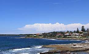
Southerly busters occur about 32 times each year on the coast of southeastern Australia, with variable strength, usually in spring and summer. Although southerly busters are often associated with NSW and Victoria, they also occur on the east coast of Tasmania, New Zealand, and in Argentina and Chile.[3] They are known as ‘backdoor fronts’ in North America, and ‘Spanish plumes’ in Western Europe.[4]
History
On hot afternoons in the late nineteenth century, before the days of radio, the Sydney Observatory would fly a flag bearing the letters "JB" to indicate that the southerly buster had reached Jervis Bay, about 150 km to the south as the crow flies.[5] The people of Sydney greeted the arrival of the southerly buster after a hot summer day. During the early days of the European settlement, Sydney's summer storms were accompanied by rolling red dust from the colony's brickworks.[6] In 1879, George Herbert Gibson published a book called Southerly Busters, where a buster wreaks havoc near Hyde Park, Sydney. Author Ruth Park makes a reference to the southerly buster in her novel Poor Man's Orange (1949):[6]
After an unbearably hot day, the old men on the balconies were sniffing the air and saying, 'Here she comes!' The Southerly Buster, the genie of Sydney, flapped its coarse wing over the city ... The women undid the fronts of their frocks and the little children lifted up their shirts and let it blow on their sweaty bottoms.
Formation
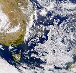
On a hot day, a strong offsea gale develops from the south usually in the late afternoon and early evening, causing a rapid fall in temperature as it arrives, and sometimes a short rain and/or thunderstorm may accompany, especially if it's affiliated with a cold front coming from the south and a trough, with the strongest winds being at the leading edge of the buster. However, the southerly buster does not always create precipitation, aside from light drizzle and light rain, which tend to occur a day after the southerly buster's arrival as its effects may still persist for 24 hours.[8] It is proposed that the southerly buster is basically a coastal gravity current that is held against the mountains by the Coriolis force and in transverse geostrophic balance, and is generated when a cold front is obstructed, experiencing anticyclonic distortion near the Great Dividing Range, spreading northward as a coastal trapped orographic jet.[9]
The southerly buster is caused by its interaction with the Great Dividing Range, as the cool air becomes trapped against the ranges, oftentimes in the Gippsland area of Victoria, where the mountains create a channelling effect as the southerly winds move across the New South Wales coast. When the inland portion of the cold front is held against the mountains, the part over the sea proceeds to move along the shore, twisting the front into an 'S' shape. This activity continues on the southern New South Wales coast, while areas leading the front are still experiencing hot northwesterly winds.[10]
Characteristics
The main distinguishing feature of a southerly buster is the sudden, squally southerly change in wind direction which replace the continental northwesterly winds.[11] This is accompanied by a marked temperature drop and sea level pressure rise. Wind gusts in excess of 40 knots (74 km/hour) near ground level averages about three per year, which usually come about after very hot days and would tremendously ease within 30 to 60 minutes after the Buster's arrival, becoming rather light within a few hours. A regular southerly buster is between 20 and 60 nautical miles wide, with the heavier winds concentrated on the seaward strip, with its depth being around 1000m, restricted by the height of the mountains to west.[12]
An orographic jet, the southerly buster is clearly a mesoscale phenomenon, developing on about one day. Because busters seldom keep a staunch speed while advancing along the coast, its arrival has always been difficult to foretell, though meteorologists nowadays have the gain of satellite imagery and weather radar to foresee it, with wind warning issued by the Bureau of Meteorology. Temperature changes can be dramatic, with falls of 10 °C (18 °F) to 15 °C (27 °F) often occurring in a few minutes.[13] In extreme conditions, a southerly buster may lower the temperatures from 40 °C (104 °F) to 19 °C (66 °F).[14][12] To note, some southerly busters can be mild and not very pronounced, where they would arrive on lukewarm days and even during sultry thunderstorm events, bringing in light, though still noticeably cooler winds in the evening, with its affects still remaining in the following few days as well in some cases.[15]
Regions
- In New South Wales, southerly busters generally reach their maximum intensity between Nowra in the South Coast and Newcastle. Southerly busters rarely pass beyond the Mid North Coast or Port Macquarie – When they do they are usually strengthened by the presence of a tropical cyclone off the north coast of the state. Moreover, they are less pronounced in that region with narrower temperature changes. Not restricted to the immediate coast, southerly busters do generally impinge upon the inland regions of NSW as well, namely the regions in the southeastern block of the state, such as, the Greater Western Sydney area, eastern portion of the Central Tablelands region going eastwards from Bathurst, the lower Hunter Valley region, Albury in the South West Slopes in a few occasions, Cooma in the Monaro (New South Wales) to the south, Canberra in the ACT, Goulburn in the Southern Tablelands and the Snowy Mountains, with the latter regions having the most dramatic cool changes due to their southerly vicinity.[16] Sydney receives an average of about five Southerly Busters a year, mostly in late spring and early summer, with the stronger ones generally reaching the city in the late afternoon or early evening on a hot day, though at times it would arrive after several days of hot weather. It is a crucial weather feature in the Sydney area, particularly for yachtsmen.[10]
- In Victoria, most notably in Melbourne, southerly busters occur during the afternoons where the domineering heat, brought on by north-westerly winds from central Australia, suddenly gives way to a rapid drop in temperature, followed by rain, thunderstorms and a relatively cool night. They would reach as far inland as Swan Hill in the north and Omeo to the east, but would be less pronounced and intense as one moves more inland to the north. Temperature drops in these parts of Victoria are more dramatic than those in the east coast of New South Wales, where a 10°C (18°F) drop can occur within half an hour (part of the easily changeable weather).[17] Southerly busters most emerge in spring, as the landmass northbound of Melbourne starts to warm up. Meanwhile, though, the Southern Ocean, which provides cool breezes to Victoria from the west, does not warm up as swiftly as the mainland. As such, the temperature difference between hot air from the north and cold from the ocean would be very great, thus providing good conditions for the formation of thunderstorms.[18]
- In South Australia, Mount Gambier would the most affected by southerly busters in the state due to its southeasterly location. The buster may also reach Adelaide and Whyalla in some occasions.[19]
- In Western Australia, the Buster occasionally reaches Eucla due to its location near the Southern Ocean in the warm months, where it can experience dramatic temperature drops.[20]
- In Wellington, New Zealand these storms are normally short and frequently have winds gusting between 120 km/h and 160 km/h though higher speeds are known.
- In South America, these southerly fronts frequently encroach on the southern coast of Chile and Argentina and would then advance northwards on both sides of the Andes.[21]
- In North America, the south moving 'back-door' cold front on the eastern side of the Alleghenies in the northeastern US is comparable to the southern buster of the southern hemisphere.[22]
Records
The strongest recorded Southerly Buster fell around 4:30 pm on 12 March 2010 in Wellington, New Zealand, with a maximum gust recorded of 72 knots (133 km/h). [23]
Warning Signals at the Port of Sydney
From the early days of settlement at Sydney Cove sudden southerly squalls had been a problem for boats in the harbour[24]. In 1829, a brickfielder as these squalls as were now called, laid the boat carrying Govenor Ralph Darling and his family on its beam ends[25]. Later the term 'southerly buster' would also be used[26].
In 1869, following the connection of lighthouses and signal stations on the east coast of NSW to the electric telegraph network, a system was instituted to give shipping warning of approaching gales[27]. It would give boats in Port Jackson warning of approaching busters. The new signals were included in Gowland's[28] ammendments to the NSW Sailing Directory[29]

The signal was a diamond shape (see Day shapes) on the southern yard-arm of the signal mast to indicate a squall approaching from the south, and numeral pendants per John Nicholson's Code of Signals[30] flying on the masthead to show the location of the squall. The numbers were those already in use from 1842 for identifying ports[31], eg Jervis Bay was 46 and Wollongong, added in 1854[32] , was 82. The signal masts were at South Head Signal Station and Fort Phillip. These masts had two yard-arms at right angles aligned north-south and east-west.
From 1876 signals would be displayed at two additional places - the new flagstaff at Bradley's Head and the Floating Light Vessel at the entrance to the Harbour.[33] This direction specified that a cone signal on the flagstaff would indicate the approach of a southerly squall. This signal "A cone, with the point downwards, shows that a gale is probable; at first from the southward."[34] was introduced in England 1861[35] by Robert Fitzroy, but this appears to be the first time it was used in Port Jackson.
In November 1898, the Postmaster General, Varney Parkes[36], announced that that a white flag with the letters E, J.B. or W would be flown from the flagstaff on the clock tower of the Sydney General Post Office to signal the approach of a southerly buster. As the wind reached Eden, Jervis Bay or Wollongong the relevant flag would be hoisted.[37] The J.B. flag was hoisted for the first time on 10 February 1899 but the wind did not travel beyond Kiama[38]. The day had been hot and oppressive and the much anticipated cool change didn't eventuate.
The original intention was to change the flags as the change moved north but this didn't always happen.[39] It was possibly later reduced to just two flags, JB and W. [40]
On the night of 16 December 1908 a new signal, also on the GPO clock tower, made its debut[41]. For warnings at night a red light had been installed in the lantern - the glass enclosed room below the flagstaff. It continued until 1940.[42]
Capsizes still occurred[43][44], but fishing boats did heed the warnings[45].
Incidents
On 21 November 2016, at around 6pm, a powerful southerly change occurred in Melbourne, which resulted in the death of 10 people, who were asthmatic and succumbed to respiratory failure.[46] Thousands of others across the city experienced allergic reactions and asthma-like symptoms triggered by the storm.[47] This was due to a stark southerly wind (60 km/hour) that distributed ryegrass pollen into the moist air, rupturing them into very fine specks, small enough particles to enter people's lungs, as they were sucked up into the warm updraft of air forming the storm cells, before they returned to earth in the storm's cool down-draft, spreading across the land in the storm's efflux area.[48] Hospitals and medical centres in the city had to arduously manage 8,500 emergency calls in the space of just five hours, and the hospitalisation of 1400 people.[49]
References
- "SOUTHERLY BUSTER". Wellington Times. NSW: National Library of Australia. 23 December 1901. p. 2. Retrieved 27 March 2015.
- Southerly Busters Explained. The Australian Government Bureau of Meteorology. Accessed 21 February 2012.
- Naranjo, Ralph (1 December 1994), "Forecasts and false steps. (includes related information on June 1994 Pacific storm)(Safety at Sea)", Cruising World, Bonnier Corporation, 20 (12): 42, ISSN 0098-3519
- Cassiily, M. 1945. The frontology of sub-tropical Australia. RAAF Met. Services Weather Development and Res. Bulletin. 1. 5–28.
- 1850, B. C. Peck, Recollections of Sydney, quoted in 1978, G. A. Wilkes, A Dictionary of Australian Colloquialisms, ISBN 0-424-00034-2
- Arthur Phillip Chapter of Fellowship of First Fleeters – WEATHER SECRETS OF THE FIRST FLEET VOYAGE
- Helen J. Reid and Lance M. Leslie School of Mathematics, University of New South Wales, Sydney, Australia
- "Journal of Meteorology". Volume 20 (200–204). Artetech International. 1995: 213. Cite journal requires
|journal=(help) - ""Southerly Buster" Relieves City". The Sydney Morning Herald. National Library of Australia. 17 December 1953. p. 1. Retrieved 27 March 2015.
- The Big Bust - Southerly Busters Explained! - The Bureau of Meteorology
- 1997, Peter Baines, Kathy McInnes, 24. The southerly buster, Eric Kenneth Webb (editor), Windows on Meteorology: Australian Perspective,
- Berson, F.A., bid, D.G. and Troup, A.J. 1957. The summer cool change at southeastern Australia. I. General behaviour. Tech. Pap. No. 8. CSIRO Div. of Met. Phys.
- THE DYNAMICS OF THE SOUTHERLY BUSTER P.G. Baines CSIRO Division of Atmospheric physics, Aspendale, June 1980
- Storms and showers hit Sydney after a hot week of weather by Louise Starkey, The Sunday Telegraph
- Climate Change in the Sydney Metropolitan Catchments
- Victoria. Ports and Harbors Division (1970), Sailing directions : Victoria including Bass Strait, Government Printer, retrieved 27 March 2015 – page 25 lines 15 – 29... regarding the prevalence of the Southerly Buster in a widespread area of south-east Australia, and not confined to Sydney.
- Melbourne weather: Quick change sees temperature slip from sticky to chilly by Emily Woods, Ebony Bowden. 27 March 2017. The Age
- Melbourne weather: How winds from the north and west create 'change days' by Belinda Smith, Tuesday 13 November 2018
- Southerly Buster cools southern Australia by Al Jazeera, Richard Angwin, 20 November 2012
- [https://trove.nla.gov.au/newspaper/article/54161361 The Register News Pictorial, 1930
- meteorological reports. 1949. Aviation meteorology of south America. Met. Office Reports, VoI.,1, 1–50.
- Ebsart, L.F., Pagnotti, V. and Lettau, B. 19 . Climatological aspects of Eastern United States back-door cold frontal passages.Mon. Weath Rev., 101, 627–35,
- "March 2010 Wellington and Marlborough Storm ( 2010-03-12 )". hwe.niwa.co.nz. Retrieved 22 March 2020.
- "SYDNEY". The Sydney Gazette And New South Wales Advertiser. III, (147). New South Wales, Australia. 22 December 1805. p. 2. Retrieved 26 June 2020 – via National Library of Australia.CS1 maint: extra punctuation (link)
- "INQUESTS". The Australian (447). New South Wales, Australia. 9 October 1829. p. 3. Retrieved 26 June 2020 – via National Library of Australia.
- "CONSISTENT TO THE LAST". The People's Advocate And New South Wales Vindicator. V, (222). New South Wales, Australia. 22 January 1853. p. 4. Retrieved 26 June 2020 – via National Library of Australia.CS1 maint: extra punctuation (link)
- "TELEGRAPHIC COAST DANGER SIGNALS". New South Wales Government Gazette. New South Wales, Australia. 16 July 1869. p. 1797. Retrieved 3 June 2020 – via Trove.
- "Commander Gowlland". Australian Town And Country Journal. New South Wales, Australia. 22 August 1874. p. 13. Retrieved 15 June 2020 – via Trove.
- Additions and Corrections to the present Admiralty Sailing Directory for the Coast of New South Wales, Navigating Lieut. J.T.Gowlland R.N., Sydney, Thomas Richards Govt. Printer 1870
- https://www2.sl.nsw.gov.au/archive/curio/exhibit/1318/storiesc049.html?from_collection=2&page=4
- "SIGNALS AT FORT PHILLIP, FOR VESSELS ARRIVING IN PORT JACKSON". New South Wales Government Gazette. New South Wales, Australia. 7 January 1842. p. 12. Retrieved 3 June 2020 – via Trove.
- "LIGHTHOUSE ON MOUILLE POINT". The Sydney Morning Herald. New South Wales, Australia. 14 September 1854. p. 4. Retrieved 11 June 2020 – via Trove.
- "NOTICE TO MARINERS". New South Wales Government Gazette. New South Wales, Australia. 5 September 1876. p. 3510. Retrieved 4 June 2020 – via Trove.
- The Weather Book : A Manual of Practical Meteorology, Rear Admiral FITZROY. - London : Longman, Green, Longman, Roberts, & Green. 1 8 6 3.- p. 347
- Jim Burton. “Robert FitzRoy and the Early History of the Meteorological Office.” The British Journal for the History of Science, vol. 19, no. 2, 1986, p 161. JSTOR, www.jstor.org/stable/4026590. Accessed 11 June 2020
- http://adb.anu.edu.au/biography/parkes-varney-7959
- "WINDS THAT BLOW FROM THE SOUTH". The Sydney Morning Herald. New South Wales, Australia. 22 November 1898. p. 4 Col 6. Retrieved 6 June 2020 – via Trove.
- "THE WEATHER". The Sydney Morning Herald. New South Wales, Australia. 11 February 1899. p. 9. Retrieved 6 June 2020 – via Trove.
- "THE CRITIC". Truth. New South Wales, Australia. 25 June 1899. p. 1. Retrieved 7 June 2020 – via Trove.
- H.O Publication No. 169, Australia Pilot, Volume III, 2nd Edition 1930, United States Govt Printing Office
- "THE RED LIGHT". The Sydney Morning Herald. New South Wales, Australia. 17 December 1908. p. 7. Retrieved 7 June 2020 – via Trove.
- "Mrs. ENDACOTT (of Parramatta) wants to know". The Daily Telegraph. New South Wales, Australia. 27 July 1941. p. 7 (Sunday Telegraph News-Review Section). Retrieved 7 June 2020 – via Trove.
- "STRONG SOUTHERLY". Sunday Times. New South Wales, Australia. 8 November 1908. p. 11. Retrieved 8 June 2020 – via Trove.
- "SAILING". The Sydney Morning Herald. New South Wales, Australia. 9 February 1921. p. 13. Retrieved 8 June 2020 – via Trove.
- "IN THE SIGNAL STATION". Evening News. New South Wales, Australia. 11 October 1906. p. 6. Retrieved 8 June 2020 – via Trove.
- Melbourne thunderstorm asthma victims left waiting for ambulances which had not been despatched by Karen Percy (ABC News)
- Coronial investigation uncovers tenth thunderstorm asthma death by Aisha Dow (The Age)
- Thunderstorm asthma deaths: ambulance dispatch 'unlikely' factor – coroner by Melissa Davey (The Guardian)
- Inquest into deaths of 10 Victorians from thunderstorm asthma hears common theme by Rohan Smith (News.com.au)