South Carolina Highway 68
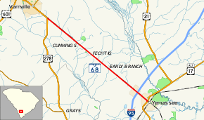
South Carolina Highway 68 (SC 68) is a 15.3-mile (24.6 km) state highway in Hampton County, South Carolina, connecting the Hampton–Varnille area with Yemassee and Interstate 95 (I-95).
| ||||
|---|---|---|---|---|
| Yemassee Highway | ||||
 | ||||
| Route information | ||||
| Maintained by SCDOT | ||||
| Length | 15.33 mi[1] (24.67 km) | |||
| Existed | 1967–present | |||
| Major junctions | ||||
| West end | ||||
| East end | ||||
| Location | ||||
| Counties | Hampton | |||
| Highway system | ||||
| ||||

Route description
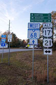
The route of SC 68 travels generally in a northwest to southeast direction, beginning at a junction with U.S. Highway 278 (US 278 just south of Varnville. The highway travels in a nearly straight line for its entire length, paralleling the Port Royal and Augusta Railway. The roadway passes through the small hamlet of Early Branch before widening to a four-lane configuration about one mile (1.6 km) north of the I-95 junction. Passing underneath I-95, SC 68 returns to a two-lane configuration as it enters Yemassee before terminating at an intersection with US 17 Alternate and US 21.[2]
History
Established in 1967 as a renumbering of SC 28, it has remained unchanged since. Prior to the current routing, SC 68 had two previous incarnations: In 1937-38 from Clio to the North Carolina state line (renumbered as SC 83), and in 1938-47 as a short highway spur from US 78 in Denmark.[3]
Junction list
The entire route is in Hampton County.
| Location | mi[1] | km | Destinations | Notes | |
|---|---|---|---|---|---|
| Almeda | 0.00 | 0.00 | |||
| Yemassee | 13.58 | 21.85 | Exit 38 (I-95) | ||
| 15.33 | 24.67 | ||||
| 1.000 mi = 1.609 km; 1.000 km = 0.621 mi | |||||
References
- South Carolina Department of Transportation: Statewide Highways 2012. Specifics: . Files: .
- Google (December 30, 2012). "South Carolina Highway 68" (Map). Google Maps. Google. Retrieved December 30, 2012.
- "Mapmikey's South Carolina Highways Page". Retrieved December 30, 2012.
External links
