South Carolina Highway 513
South Carolina Highway 513 (SC 513) is a 8.8-mile-long (14.2 km) state highway in the U.S. state of South Carolina. The highway travels through rural areas of Georgetown County.
| ||||
|---|---|---|---|---|
| ||||
| Route information | ||||
| Maintained by SCDOT | ||||
| Length | 8.81 mi[1] (14.18 km) | |||
| Major junctions | ||||
| South end | ||||
| North end | ||||
| Location | ||||
| Counties | Williamsburg, Georgetown | |||
| Highway system | ||||
| ||||

Route description
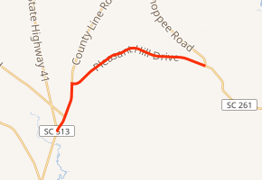
SC 513 begins at an intersection with SC 41/SC 51 (County Line Road) south-southwest of Hopewell, on the Williamsburg–Georgetown county line. It travels to the north-northeast, on the county line, and nearly immediately intersects the eastern terminus of SC 512 (Henry Road). The highway turns right onto Pleasant Hill Drive and travels to the east into Georgetown County proper. It curves to the northeast before crossing over Browns Branch. It curves to the east and east-southeast and meets its northern terminus, an intersection with SC 261 (Pleasant Hill Drive/Choppee Road) just north of Carters Crossroads.[2]
Major intersections
| County | Location | mi[2] | km | Destinations | Notes |
|---|---|---|---|---|---|
| Williamsburg–Georgetown county line | | 0.00 | 0.00 | ||
| | 0.81 | 1.30 | Eastern terminus of SC 512 | ||
| Georgetown | | 8.87 | 14.27 | ||
| 1.000 mi = 1.609 km; 1.000 km = 0.621 mi | |||||
See also


References
- "Statewide Highways (shapefile)" (zip). South Carolina Department of Transportation. September 29, 2017. Retrieved December 8, 2017.
- Google (May 16, 2016). "South Carolina Highway 513" (Map). Google Maps. Google. Retrieved May 16, 2016.
External links

- SC 513 South Carolina Hwy Index