South Carolina Highway 512
South Carolina Highway 512 (SC 512) is a 24 1⁄4-mile-long (39.0 km) state highway in the U.S. state of South Carolina. The highway connects Cades and rural areas of northeastern Williamsburg County.
| ||||
|---|---|---|---|---|
| ||||
| Route information | ||||
| Maintained by SCDOT | ||||
| Length | 24.25 mi[1] (39.03 km) | |||
| Major junctions | ||||
| West end | ||||
| East end | ||||
| Location | ||||
| Counties | Williamsburg | |||
| Highway system | ||||
| ||||

Route description
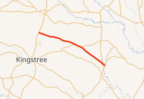
SC 512 begins at an intersection with U.S. Route 52 (US 52; Williamsburg County Highway) in Cades, Williamsburg County, where the roadway continues as Cade Road. It travels to the east-southeast and immediately enters the main part of Cades, where it crosses over some CSX railroad line. It continues to the east-southeast and crosses over McNamee and Paisley swamps before it intersects SC 261 (Hemingway Highway). The two highways travel concurrently to the southeast. Immediately, they cross over Boggy Swamp. They pass Battery Park Elementary School before traveling through Indiantown. Just to the east-southeast of Indiantown is where the two highways split. SC 512 travels to the southeast and crosses over Indiantown Swamp. It crosses over some railroad tracks and Poplar Hill Branch. After an intersection with SC 41/SC 51, it meets its eastern terminus, an intersection with SC 513 (County Line Road) on the Georgetown County line. Here, the roadway continues as a local road to the southeast.[2]
Major intersections
The entire route is in Williamsburg County.
| Location | mi[2] | km | Destinations | Notes | |
|---|---|---|---|---|---|
| Cades | 0.00 | 0.00 | |||
| | 12.09 | 19.46 | Western end of SC 261 concurrency | ||
| | 14.55 | 23.42 | Eastern end of SC 261 concurrency | ||
| | 23.49 | 37.80 | |||
| | 24.25 | 39.03 | On the Georgetown County line | ||
1.000 mi = 1.609 km; 1.000 km = 0.621 mi
| |||||
See also


References
- "Statewide Highways (shapefile)" (zip). South Carolina Department of Transportation. September 29, 2017. Retrieved December 8, 2017.
- Google (May 16, 2016). "South Carolina Highway 512" (Map). Google Maps. Google. Retrieved May 16, 2016.
External links

- SC 512 South Carolina Hwy Index