South Carolina Highway 460
South Carolina Highway 460 (SC 460) is a primary state highway in the U.S. state of South Carolina. It serves as an bypass of SC 160, from Tega Cay to east of Fort Mill.
| ||||
|---|---|---|---|---|
 | ||||
| Route information | ||||
| Maintained by SCDOT | ||||
| Length | 7.5 mi[1] (12.1 km) | |||
| Existed | 2012–present | |||
| Major junctions | ||||
| West end | ||||
| East end | ||||
| Location | ||||
| Counties | York | |||
| Highway system | ||||
| ||||

Route description
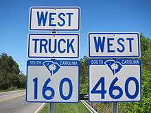
Truck SC 160 and SC 460 in Fort Mill
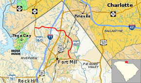
SC 460 traverses 7.5 miles (12.1 km) from Tega Cay to Fort Mill, half of which is overlapped with Truck SC 160.
Alternate names
Though the highway is commonly known as "SC 460" or "Highway 460" throughout the state, the highway does have other known names it uses locally in areas.
- Becky Meacham-Richardson Highway – official South Carolina honorary name of SC 460, from SC 160, in Tega Cay, to Deerfield Drive. Becky Meacham-Richardson served as a state representative for the Lake Wylie/Tega Cay area.
- Gold Hill Road – road name of highway from SC 160, in Tega Cay, to Deerfield Drive.
- Springfield Parkway – road name of highway from Deerfield Drive to SC 160, in Fort Mill.
History
Established on March 28, 2012 as a new primary route, it follows existing roads: Gold Hill Road and Springfield Parkway.[2]
Junction list
The entire route is in York County.
| Location | mi[1] | km | Destinations | Notes | |
|---|---|---|---|---|---|
| Tega Cay | 0.0 | 0.0 | To Steele Creek | ||
| | 2.0 | 3.2 | Exit 88 (I-77) | ||
| | 3.3 | 5.3 | West end of SC 160 Truck overlap | ||
| | 3.7 | 6.0 | North end of US 21 Bus overlap | ||
| | 4.3 | 6.9 | South end of US 21 Bus overlap | ||
| Fort Mill | 7.5 | 12.1 | East end of SC 160 Truck overlap | ||
1.000 mi = 1.609 km; 1.000 km = 0.621 mi
| |||||
References
- Google (2012-04-07). "South Carolina Highway 460" (Map). Google Maps. Google. Retrieved 2012-04-07.
- "Flickr - SCDOT Date Tag of SC 460 Sign". Retrieved 2012-04-08.
External links
| Wikimedia Commons has media related to South Carolina Highway 460. |
This article is issued from Wikipedia. The text is licensed under Creative Commons - Attribution - Sharealike. Additional terms may apply for the media files.