South Carolina Highway 453
South Carolina Highway 453 (SC 453) is a 14.8-mile-long (23.8 km) state highway in the U.S. state of South Carolina. The highway connects Harleyville and Eutawville, via Holly Hill.
| ||||
|---|---|---|---|---|
| ||||
| Route information | ||||
| Maintained by SCDOT | ||||
| Length | 14.8 mi[1] (23.8 km) | |||
| Major junctions | ||||
| South end | ||||
| ||||
| North end | ||||
| Location | ||||
| Counties | Dorchester, Orangeburg | |||
| Highway system | ||||
| ||||

Route description
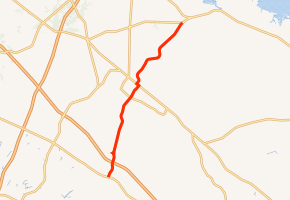
SC 453 begins at an intersection with U.S. Route 178 (US 178; West Main Street) in Harleyville, Dorchester County. It travels to the north-northeast and crosses over some railroad tracks just before an interchange with Interstate 26 (I-26). Right after it intersects 7 Mile Road, it parallels some railroad tracks for approximately three miles (4.8 km). Shortly after that stretch, it enters Orangeburg County. Just before entering Bowyer, SC 453 crosses over Home Branch. In the town of Holly Hill, it travels southeast of Gilmore Park. The highway intersects US 176 (Old State Road). The two highways travel concurrently to the northwest for about three blocks. It travels to the northeast and curves to the north-northwest. It curves back to the northeast and passes Holly Hill Academy just before crossing Briner Branch. The highway continues to the northeast, through rural areas and enters Eutawville. Almost as soon as it enters town, it meets its northern terminus, an intersection with SC 45 (Branchville Highway/Eutaw Road).[1]
Major intersections
| County | Location | mi[1] | km | Destinations | Notes |
|---|---|---|---|---|---|
| Dorchester | Harleyville | 0.0 | 0.0 | Southern terminus | |
| | 1.2 | 1.9 | I-26 exit 177 | ||
| Orangeburg | Holly Hill | 7.9 | 12.7 | Southern end of US 176 concurrency | |
| 8.2 | 13.2 | Northern end of US 176 concurrency | |||
| Eutawville | 14.8 | 23.8 | Northern terminus | ||
1.000 mi = 1.609 km; 1.000 km = 0.621 mi
| |||||
See also


References
- Google (May 16, 2016). "South Carolina Highway 453" (Map). Google Maps. Google. Retrieved May 16, 2016.
External links

- SC 453 South Carolina Hwy Index