South Carolina Highway 160
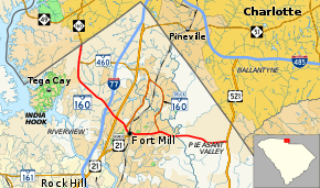
South Carolina Highway 160 (SC 160) is a primary state highway in the U.S. state of South Carolina. It runs from North Carolina state line, through the towns of Tega Cay and Fort Mill, ending in Indian Land.
| ||||
|---|---|---|---|---|
 | ||||
| Route information | ||||
| Maintained by SCDOT | ||||
| Length | 11.04 mi[1] (17.77 km) | |||
| Existed | 1942–present | |||
| Major junctions | ||||
| West end | ||||
| East end | ||||
| Location | ||||
| Counties | York, Lancaster | |||
| Highway system | ||||
| ||||

Route description
SC 160 begins at the North Carolina state line near the Steele Creek area of Charlotte, North Carolina. Going southeast, it crosses Gold Hill Road in Tega Cay before entering Fort Mill. The highway goes through the downtown area of Fort Mill, connecting briefly with U.S. Route 21 Business (US 21 Bus.). Continuing east, it ends at US 521 in Indian Land. The route width varies between two lanes and five lanes.[2]
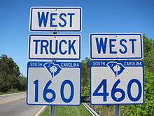
Alternate names
Though the highway is commonly known as "SC 160" or "Highway 160" throughout the state, the highway does have other known names it uses locally in areas.
- Fort Mill Highway – road name of highway west of Fort Mill to Lancaster County, though sometimes used interchangeably for entire route.
- John D. Patterson Memorial Highway – official South Carolina honorary name of SC 160 in Lancaster County.[3]
History
The highway was established in 1942 as a renumbering of the second SC 211. The route has changed little since.[4]
Old signs along highway use a north–south designation; newer signs designate the highway as east–west.
Junction list
| County | Location | mi[1] | km | Destinations | Notes |
|---|---|---|---|---|---|
| York | | 0.00 | 0.00 | North Carolina state line | |
| | 0.96 | 1.54 | Western terminus of SC 460 | ||
| | 3.92 | 6.31 | Exit 85 (I-77) | ||
| Fort Mill | 4.63 | 7.45 | Western terminus of SC 160 Truck | ||
| 5.38 | 8.66 | Western end of US 21 Bus. concurrency | |||
| 5.77 | 9.29 | Eastern end of US 21 Bus. concurrency | |||
| 7.38 | 11.88 | Eastern termini of SC 460 / SC 160 Truck | |||
| Lancaster | Indian Land | 11.04 | 17.77 | ||
1.000 mi = 1.609 km; 1.000 km = 0.621 mi
| |||||
Fort Mill truck route
| |
|---|---|
| Location | Fort Mill, South Carolina |
| Length | 6.99 mi[1] (11.25 km) |
| Existed | December 2007–present |
SC 160 Truck is a 2.7-mile-long (4.3 km) truck route that bypasses downtown Fort Mill. Starting in the west, it follows US 21 north to SC 460 (Springfield Parkway), where it goes southeast back to SC 160.[5]
References
- South Carolina Department of Transportation: Statewide Highways 2012. Specifics: . Files: .
- Google (2012-01-08). "South Carolina Highway 160" (Map). Google Maps. Google. Retrieved 2012-01-08.
- "South Carolina Legislature Online - Bill #4952". Retrieved 2012-01-08.
- "Mapmikey's South Carolina Highways Page: SC 160". Retrieved 2012-01-08.
- Google (2012-01-08). "SC 160 Truck - Fort Mill" (Map). Google Maps. Google. Retrieved 2012-01-08.
External links
| Wikimedia Commons has media related to South Carolina Highway 160. |