South Carolina Highway 308
South Carolina Highway 308 (SC 308) is a 10.9-mile-long (17.5 km) state highway in the U.S. state of South Carolina. The highway connects Ora and Clinton.
| ||||
|---|---|---|---|---|
| ||||
| Route information | ||||
| Maintained by SCDOT | ||||
| Length | 10.9 mi[1] (17.5 km) | |||
| Existed | 1949–present | |||
| Major junctions | ||||
| West end | ||||
| East end | ||||
| Location | ||||
| Counties | Laurens | |||
| Highway system | ||||
| ||||

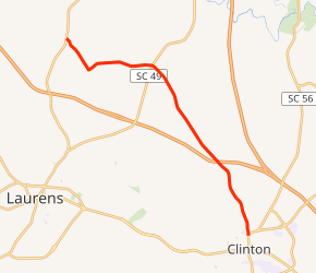
Route description
SC 308 begins at an intersection with U.S. Route 221 in Ora, Laurens County. It travels to the southeast and curves to the northeast. Then, it heads to the east and intersects SC 49. It crosses Duncan Creek, which leads into Clinton Reservoir. The highway passes Clinton Reservoir Tract Wildlife Management Area. After that, it crosses over Long Branch before an interchange with Interstate 385 (I-385; Veterans Memorial Highway). SC 308 crosses over Beards Fork Creek before entering Clinton. There, it meets its eastern terminus, an intersection with SC 56 Business (SC 56 Bus.) and SC 72 Bus. (North Broad Street/Willard Road).[1]
History
Major intersections
The entire route is in Laurens County.
| Location | mi[1] | km | Destinations | Notes | |
|---|---|---|---|---|---|
| Ora | 0.0 | 0.0 | |||
| | 3.8 | 6.1 | |||
| | 7.9 | 12.7 | Exit 2 (I-385) | ||
| Clinton | 10.9 | 17.5 | |||
| 1.000 mi = 1.609 km; 1.000 km = 0.621 mi | |||||
See also


References
- Google (May 13, 2016). "South Carolina Highway 308" (Map). Google Maps. Google. Retrieved May 13, 2016.
External links

- Mapmikey's South Carolina Highways Page: SC 300-309