South Carolina Highway 310
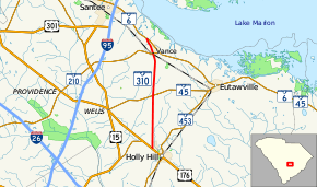
South Carolina Highway 310 (SC 310) is an 8.5-mile (13.7 km) long state highway in the southeastern part of the U.S. state of South Carolina. The highway travels in a south-north orientation from Holly Hill north to Vance, and then northwest to its northern terminus, completely within Orangeburg County.
| ||||
|---|---|---|---|---|
 | ||||
| Route information | ||||
| Maintained by SCDOT | ||||
| Length | 8.50 mi[1] (13.68 km) | |||
| Major junctions | ||||
| South end | ||||
| North end | ||||
| Location | ||||
| Counties | Orangeburg | |||
| Highway system | ||||
| ||||

Route description
SC 310 begins at an intersection with US 176 in Holly Hill. The route heads north to an intersection with SC 45, north of the city. The road continues north into the city of Vance, where it intersects SC 210. After leaving Vance, SC 310 heads northwest and meets its northern terminus, an intersection with SC 6, just northwest of the city.[2]
SC 310 is not part of the National Highway System, a system of roadways important to the nation's economy, defense, and mobility.[3]
History
Major intersections
The entire route is in Orangeburg County.
| Location | mi[1] | km | Destinations | Notes | |
|---|---|---|---|---|---|
| Holly Hill | 0.00 | 0.00 | |||
| | 4.02 | 6.47 | |||
| Vance | 7.25 | 11.67 | |||
| | 8.50 | 13.68 | |||
| 1.000 mi = 1.609 km; 1.000 km = 0.621 mi | |||||
See also


References
- South Carolina Department of Transportation: Statewide Highways 2012. Specifics: . Files: .
- Google (February 2, 2013). "Route of SC 310" (Map). Google Maps. Google. Retrieved February 2, 2013.
- "National Highway System: South Carolina" (PDF). United States Department of Transportation. October 1, 2012. Retrieved July 1, 2013.
External links
