South Carolina Highway 290
South Carolina Highway 290 (SC 290) is a state highway in South Carolina, United States, that courses through central Greenville and Spartanburg Counties.
| ||||
|---|---|---|---|---|
| ||||
| Route information | ||||
| Maintained by SCDOT | ||||
| Length | 30.78 mi[1] (49.54 km) | |||
| Existed | 1938–present | |||
| Major junctions | ||||
| West end | ||||
| East end | ||||
| Location | ||||
| Counties | Greenville, Spartanburg | |||
| Highway system | ||||
| ||||

Route description
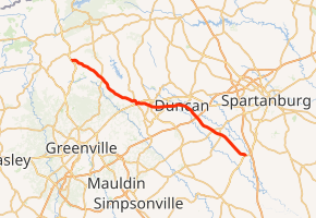
The west terminus of South Carolina Highway 290 is with its junction with US Highway 25 (US 25) approximately halfway between Travelers Rest and Tigerville. It generally follows a southeast route through the small villages of Locust Hill and Sandy Flat before entering Greer. Within Greer, its course changes to an easterly direction and it continues over the county border into Spartanburg County. SC 290's course changes back to a southeasterly direction as it passes through Duncan. It then crosses Interstate 85 (I-85) at exit 63 and continues on until it reaches its east terminus, the junction with US 221, in Moore.[2][3]
Major intersections
| County | Location | mi[1] | km | Destinations | Notes |
|---|---|---|---|---|---|
| Greenville | | 0.00 | 0.00 | ||
| Sandy Flat | 5.38 | 8.66 | West end of SC 253 overlap | ||
| 5.53 | 8.90 | East end of SC 253 overlap | |||
| Fairview | 11.37 | 18.30 | West end of SC 101 overlap | ||
| Greer | 11.88 | 19.12 | West end of US 29 overlap | ||
| 12.13 | 19.52 | East end of US 29 overlap | |||
| 13.76 | 22.14 | ||||
| Greenville–Spartanburg county line | 14.12 | 22.72 | East end of SC 101 overlap; southern terminus of SC 357 | ||
| Spartanburg | 15.87– 16.06 | 25.54– 25.85 | Interchange | ||
| Duncan | 18.61 | 29.95 | Western terminus of SC 292 | ||
| 21.72– 21.91 | 34.95– 35.26 | I-85 exit 63 | |||
| | 24.64 | 39.65 | |||
| | 25.90 | 41.68 | |||
| Moore | 30.78 | 49.54 | |||
1.000 mi = 1.609 km; 1.000 km = 0.621 mi
| |||||
References
- "Statewide Highways (shapefile)" (zip). South Carolina Department of Transportation. September 29, 2017. Retrieved December 8, 2017.
- South Carolina DeLorme Atlas & Gazetteer, First Edition (© 1998). Pages 18–19.
- Google (June 2, 2018). "South Carolina Highway 290" (Map). Google Maps. Google. Retrieved June 2, 2018.
External links

- SC 290 South Carolina Hwy Index