Snake Island (Black Sea)
Snake Island (Greek Φιδονήσι Fidonísi), also known as Serpent Island (Romanian: Insula Șerpilor, Ukrainian: Зміїний, Russian: Змеиный), is an island located in the Black Sea, near the Danube Delta.
| Native name: Острів Зміїний | |
|---|---|
 Snake Island | |
| Geography | |
| Location | Black Sea |
| Coordinates | 45°15′N 30°12′E |
| Area | 0.17 km2 (0.066 sq mi) |
| Length | 0.662 km (0.4113 mi) |
| Width | 0.440 km (0.2734 mi) |
| Highest elevation | 41 m (135 ft) |
| Highest point | N/An |
| Administration | |
Romania 80% Ukraine 20% | |
| Demographics | |
| Population | Around 100 |
The island is populated. A rural settlement of Bile was established in February 2007.
The islet was part of a border dispute between Romania and Ukraine in 2004–2009, during which Romania contested the technical definition of the island and borders around it. The territorial limits of the continental shelf around Snake Island were delineated by the International Court of Justice in 2009.[1]
Geography
Snake Island is an igneous rock formation located 35 km from the coast, east of the mouth of the Danube River. The island's coordinates are 45°15′18″N 30°12′15″E. The island is X-shaped, 690 meters from S-W to N-E by 682 meters from N-W to S-E, covering an area of 0.205 km2. The highest area is 41 metres (135 ft) above sea level. The island does not have a prominently featured mountain, but rather a low-slope hill.
The nearest coastal location to the island is Kubanskyi Island on the Ukrainian part of the Danube Delta, located 35 km (22 mi) away between the Bystroe Channel and Skhidnyi Channel. The closest Romanian coastal city, Sulina, is 45 km (28 mi) away. The closest Ukrainian city is Vylkove, 50 km (31 mi); however, there also is a port Ust-Dunaisk, 44 km (27 mi) away from the island.
For the end of 2011 in Zmiinyi Island coastal waters 58 fish species (12 of which are included into the Red Book of Ukraine)[2] and six crab species were recorded. A presidential decree of 9 December 1998, Number 1341/98, declared the island and coastal waters as a state-protected area. The total protected area covers 232 hectares.
The island was one of the last hauling-out sites in the basin for critically endangered Mediterranean monk seals until the 1950s.[3]
Population and infrastructure
.jpg)
About 100 inhabitants live on the island, mostly frontier guard servicemen with their families and technical personnel. In 2003, an initiative of the Odessa I. I. Mechnikov National University established the Ostriv Zmiinyi marine research station every year at which scientists and students from the university conduct research on local fauna, flora, geology, meteorology, atmospheric chemistry, and hydrobiology.
The island is currently demilitarized and under rapid development. In accordance with a 1997 Treaty between Romania and Ukraine, the Ukrainian authorities withdrew an army radio division, demolished a military radar, and transferred all other infrastructure to civilians. Eventually, the Romania-Ukraine international relationships soured (see "Maritime delimitation" section) when Romania tried to assert that the island is no more than a rock in the sea. In February 2007, the Verkhovna Rada approved establishing a rural settlement as part of Vylkove city which is located some distance away at the mouth of the Danube. However, the island had been continually populated even before although not officially.
In addition to a helicopter platform, in 2002 a pier was built for ships with up to 8 meter draught, and construction of a harbour is underway. The island is supplied with navigation equipment, including a 150-year-old lighthouse. Electric power is provided by a dual solar/diesel power station. The island also has an adequately developed civil infrastructure such as the marine research station, a post office, a bank (branch of the Ukrainian bank "Aval"), the first-aid station, a satellite television provider, a phone network, a cell phone tower, and an Internet link. Most of building structures are located either in the middle of the island by a lighthouse or the northeastern peninsula of the island by its pier.
The island lacks a fresh water source.[4] Its border guard contingent is regularly resupplied by air.[5] Since 2009 the development of the island was suspended due to financing which caused a great degree of concern of local authorities asking for more funding from the state.[6]
Lighthouse
| Snake Island Lighthouse | |
|---|---|
Mаяк | |
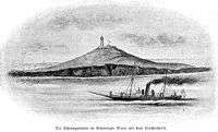 The lighthouse on the background in 1896. | |
%26groups%3D_a00a83740c8b5ca6621eb42340b5c6b49d385fc9.svg)
| |
| General information | |
| Type | service |
| Town or city | Bile (Vylkove) |
| Country | Ukraine |
| Elevation | 40 metres (130 ft) |
| Completed | autumn 1842 |
| Height | 12 metres (39 ft) |
| Design and construction | |
| Main contractor | Black Sea Fleet |
The Snake Island Lighthouse was built in the autumn of 1842[7] by the Black Sea Fleet of the Russian Empire. The lighthouse is an octagonal-shaped building, 12 meters tall, located near the highest elevated area of the island, 40 meters above the sea level. The lighthouse built on site of the previously destroyed temple of Achilles is adjacent to a housing building. The remnants of the Greek temple were found in 1823.
As lighthouse technology progressed, in 1860 new lighthouse lamps were bought from England, and one of them was installed in the Lighthouse in 1862. In the early 1890s a new kerosene lamp was installed, with lamp rotating equipment and flat lenses. It improved the lighthouse visibility to up to 20 miles (32 km). The lighthouse was either destroyed or damaged in the First World War (it is not clear which) It was subsequently rebuilt (see paragraph marked "World War I" below)
The lighthouse was heavily damaged during World War II by Soviet aviation and German retreating forces. It was restored at the end of 1944 by the Odessa military radio detachment. In 1949 it was further reconstructed and equipped by the Black Sea Fleet. The lighthouse was further upgraded in 1975 and 1984. In 1988 a new radio beacon "KPM-300" was installed with radio signal range of 150 miles (240 km).
In August 2004, the lighthouse was equipped with a radio beacon "Yantar-2M-200", which provides differential correction signal for global navigation satellite systems GPS and GLONASS.
The lighthouse is listed as UKR 050 by ARLHS, EU-182 by IOTA, and BS-07 by UIA.
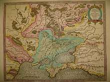
History and Mythology
The island was named by the Greeks Leuke (Greek: Λευκὴ, "White Island") and was similarly known by Romans as Alba, probably because of the white marble formations that can be found on the isle. According to Dionysius Periegetes, it was called Leuke, because the serpents there were white.[8] According to Arrian, it was called Leuke due to its color.[9] He also mention the island was also called island of Achilles (Greek: Ἀχιλλέως νῆσος[9] and Ἀχίλλεια νῆσος[10]) and racecourse of Achilles (Greek: Δρόμον Ἀχιλλέως[9] and Ἀχίλλειος δρόμος[10]).
The island was sacred to the hero Achilles and had a temple of the hero with a statue inside.[11] Solinus wrote that on the island there was a sacred shrine.[12] According to Arrian in the temple there were many offerings to Achilles and Patroclus.[9] Furthermore, people came to the island and sacrifice or set animals free in honour of Achilles.[13] He also add that people said that Achilles and Patroclus appeared in front of them as hallucinations or in their dreams while they approaching the coast of the island or sailing a short distance from it.[14] Pliny the Elder wrote that the tomb of the hero was on the island.[15]
The uninhabited isle Achilleis ("of Achilles") was the major sanctuary of the hero, where "seabirds dipped their wings in water to sweep the temples clean", according to Constantine D. Kyriazis. Several temples of Thracian Apollo can be found here, and there are submerged ruins.
According to Greek myths the island was created by Poseidon for Achilles and Helen to inhabit, but also for sailors to have an island to anchor at the Euxine Sea,[16] but the sailors should never sleep on the island.[17] According to a surviving epitome of the lost Trojan War epic of Arctinus of Miletus, the remains of Achilles and Patroclus were brought to this island by Thetis, to be put in a sanctuary, furnishing the aition, or founding myth of the Hellenic cult of Achilles centred here. According to another myth Thetis gave the island to Achilles and let him live there.[9] The oracle of Delphi sent the Leonymus (other writers called him Autoleon[18]) to the Island, telling him that there Ajax the Great would appear to him and cure his wound.[19] Leonymus said that on the island he saw the Achilles, Ajax the Great, Ajax the Lesser, Patroclus, Antilochus and Helen. In addition, Helen told him to go to Stesichorus at Himera and tell him that the loss of his sight was caused by her wrath.[20] Pomponius Mela wrote that Achilles was buried there.[21]
Ruins believed to be of a square temple dedicated to Achilles, 30 meters to a side, were discovered by the Russian naval Captain N. D. Kritzkii in 1823, but the subsequent construction of a lighthouse on the very site obliterated all trace of it.[22] Ovid, who was banished to Tomis, mentions the island, so do Ptolemy and Strabo.[23] The island is described in Pliny the Elder's Natural History, IV.27.1. It is also described in Arrian's Letter to Emperor Hadrian, a historical document movingly drawn upon by Marguerite Yourcenar in her Memoirs of Hadrian.
Several ancient inscriptions were found on the island, including a 4th-century BC Olbiopolitan decree which praises someone for defeating and driving out the pirates that lived on the "holy island".
Modern history
The Greeks during the Ottoman Empire renamed it Fidonisi (Greek: Φιδονήσι, "Snake Island") and the island gave its name to the naval Battle of Fidonisi, fought between the Ottoman and Russian fleets in 1788, during the course of the Russo-Turkish War of 1787–1792.
In 1829, following the Russo-Turkish War of 1828–1829, the island became part of the Russian Empire until 1856.
In 1877, following the Russo-Turkish War of 1877–1878, the Ottoman Empire gave the island and Northern Dobruja region to Romania, as a reimbursement for the Russian annexation of Romania's South Bessarabia region.
World War I
As part of the Romanian alliance with Russia, the Russians operated a wireless station on the island, which was destroyed on 25 June 1917 when it was bombarded by the Turkish cruiser Medilli (built as SMS Breslau of the German Navy). The lighthouse (built by Marius Michel Pasha in 1860) was also damaged and possibly destroyed.[24]
Interwar period
The 1920 Treaty of Versailles reconfirmed the island as part of Romania. The lighthouse was rebuilt in 1922.
World War II
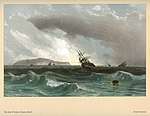
The island, under Romanian control during the Second World War, was the location of a radio station used by the Axis forces, which turned it into a target for the Soviet Black Sea Fleet.[25] The island's defences mainly consisted of several 122 mm and 76 mm anti-aircraft guns, captured from the Russians.[26] The Romanian marine platoon defending the island was also equipped with two 45 mm coastal guns, two 37 mm anti-aircraft guns and two anti-aircraft machine guns.[27]
The first naval action took place on 23 June 1941, when the Soviet destroyer leader Kharkov together with the destroyers Bezposhchadny and Smyshlyonyi and several torpedo boats ran a patrol near the island, but found no Axis ships.[28]
On 9 July 1941, the Soviet destroyer leader Tashkent together with four other destroyers (Bodry, Boiky, Bezuprechny and Bezposhchadny) conducted a shipping sweep operation near the island, but did not make any contacts.[29]
On 7 September 1941, two Soviet submarines of the Shchuka-class (Shch-208 and Shch-213) and three of the M-class (M-35, M-56 and M-62) conducted a patrol near the island.[30]
On 29–30 October and 5 November 1942, the Romanian minelayers Amiral Murgescu and Dacia, together with the Romanian destroyers Regina Maria, Regele Ferdinand, the Romanian flotilla leader Mărăști, the Romanian gunboat Stihi and four German R-boats laid two mine barrages around the island.[31]
On 1 December 1942, while the Soviet cruiser Voroshilov together with the destroyer Soobrazitelny were bombarding the island with forty-six 180 mm and fifty-seven 100 mm shells, the cruiser was damaged by Romanian mines, but it managed to return to Poti for repairs under her own power. During the brief bombardment, she struck the radio station, barracks and lighthouse on the island, but failed to inflict significant losses.[32][33][34][35][36]
On 11 December 1942, the Soviet submarine Shch-212 was sunk by a Romanian minefield near the island along with all of her crew of 44.[37][38][39] The Soviet submarine M-31 was either sunk as well by the Romanian mine barrages near the island on 17 December,[40][41] or sunk with depth charges by the Romanian flotilla leader Mărășești on 7 July 1943.[42]
On 25 August 1943, two Romanian motorboats spotted a Soviet submarine near the island and attacked her with depth charges, but it managed to escape.[43]
The Romanian marines were evacuated from the island and Soviet troops occupied it on 29–30 August 1944.[44][45]
Postwar history
The Paris Peace Treaties of 1947 between the protagonists of World War II stipulated that Romania cede Northern Bukovina, the Hertza region, Budjak, and Bessarabia to the Soviet Union, but made no mention of the mouths of the Danube and Snake Island.
Until 1948, Snake Island was a part of Romania. On February 4, 1948, during the delimitation of the frontier, Romania and the Soviet Union signed a protocol that left under Soviet administration the Snake Island and several islets on the Danube south of the 1917 Romanian-Russian border. Romania disputed the validity of this protocol, since it was never ratified by either of the two countries; nevertheless it did not make any official claim on the territories.
The same year, in 1948, during the Cold War, a Soviet radar post was built on the isle (for both naval and anti-aircraft purposes).
The Soviet Union's possession of Snake Island was confirmed in the Treaty between the Government of the People's Republic of Romania and the Government of the Union of the Soviet Socialist Republics on the Romanian-Soviet State Border Regime, Collaboration and Mutual Assistance on Border Matters, signed in Bucharest on February 27, 1961.
Between 1967 and 1987, the USSR and Romanian side negotiated the delimitation of the continental shelf. The Romanian side refused to accept a Russian offer of 4000 km2 out of 6000 km2 around the island in 1987.
Following the collapse of the Soviet Union in 1991, Ukraine inherited control over the island. A number of Romanian parties and organizations consistently claimed it should be included in its territory. According to the Romanian side, in the peace treaties of 1918 and 1920 (after World War I), the isle was considered part of Romania, and it was not mentioned in the 1947 border-changing treaty between Romania and the Soviet Union.
In 1997, Romania and Ukraine signed a treaty in which both states "reaffirm that the existing border between them is inviolable and therefore, they shall refrain, now and in future, from any attempt against the border, as well as from any demand, or act of, seizure and usurpation of part or all the territory of the Contracting Party". However, both sides have agreed that if no resolution on maritime borders can be reached within two years, then either side can go to the International Court of Justice to seek a final ruling.
In 2008, twelve Ukrainian border guards died when their helicopter flying from Odessa to Snake Island crashed, killing all but one on board.[5]
Maritime delimitation
The status of Snake Island was important for delimitation of continental shelf and exclusive economic zones between the two countries. If Snake Island were recognized as an island, then continental shelf around it should be considered as Ukrainian water. If Snake Island were not an island, but a rock,[4] then in accordance with international law the maritime boundary between Romania and Ukraine should be drawn without taking into consideration the isle location.
On 4 July 2003 the President of Romania Ion Iliescu and the President of Russia Vladimir Putin signed a treaty about friendship and cooperation. Romania promised not to contest territories of Ukraine or Moldova, which it lost to Soviet Union after World War II, but requested that Russia as a successor of the Soviet Union recognized in some form its responsibility for what had happened.[46]
On 16 September 2004 the Romanian side brought a case against Ukraine to the International Court of Justice (ICJ) in a dispute concerning the maritime boundary between the two States in the Black Sea.[47]
On February 3, 2009, the ICJ delivered its judgment, which divided the sea area of the Black Sea along a line which was between the claims of each country. The Court invoked the disproportionality test in adjudicating the dispute, noting that the ICJ, "as its jurisprudence has indicated, it may on occasion decide not to take account of very small islands or decide not to give them their full potential entitlement to maritime zones, should such an approach have a disproportionate effect on the delimitation line under consideration" and owing to a previous agreement between Ukraine and Romania, the island "should have no effect on the delimitation in this case, other than that stemming from the role of the 12-nautical-mile arc of its territorial sea" previously agreed between the parties.[48]
See also
- Snake Island (Lake Prespa)
- Bystroye Canal
- Filfla
- Maican Island
- Romania–Ukraine relations
- Soviet Black Sea Fleet during the Battle of Stalingrad
References and footnotes
Inline
- "International Court of Justice: Maritime Delimitation in the Black Sea (Romania v. Ukraine)". Archived from the original on 2008-09-24. Retrieved 2009-02-04.
- Snigirov S, Goncharov O, Sylantyev S. The fish community in Zmiinyi Island waters: structure and determinants. Marine Biodiversity 2012. doi:10.1007/s12526-012-0109-4
- Sergei R. Grinevetsky, Igor S. Zonn, Sergei S. Zhiltsov, Aleksey N. Kosarev, Andrey G. Kostianoy, 2014, The Black Sea Encyclopedia
- Ruxandra Ivan (2012). New Regionalism Or No Regionalism?: Emerging Regionalism in the Black Sea Area. Ashgate Publishing, Ltd. p. 167. ISBN 978-1-4094-2213-6.
- Ukrainian helicopter crash kills 12, Reuters, Mar 27, 2008
- An appeal of the Odessa Regional Council to the Verkhovna Rada and the Cabinet of Ministers of Ukraine on the further development of infrastructure of the Snake Island and the Bile settlement of the Kiliya Raion of Odessa Oblast. November 9, 2012.
- Vitrenko's Odessa website (in Russian)
- Dionysius of Alexandria, Guide to the Inhabited World, §540
- Arrian, Periplus of the Euxine Sea, §32
- Stephanus of Byzantium, Ethnica, §A152.9
- Pausanias, Description of Greece, § 3.19.11
- Solinus, Polyhistor, §19.1
- Arrian, Periplus of the Euxine Sea, §33
- Arrian, Periplus of the Euxine Sea, §34
- Pliny the Elder, Natural History, §4.26.1
- Philostratus, Heroica, §746
- Philostratus, Heroica, §747
- Conon, Narrations (Photius), 18
- Pausanias, Description of Greece, §3.19.12
- Pausanias, Description of Greece, §3.19.13
- Pomponius Mela, Chorographia, §2.98
- Anna S. Rusyaeva, "The temple of Achilles on the island of Leuke in the Black Sea".
- Geography, book II.5.22
- "firstworldwar.com". firstworldwar.com. Retrieved 25 June 2017.
- Robert Gardiner, Warship 1991, p. 142
- Jipa Rotaru, Ioan Damaschin, Glorie și dramă: Marina Regală Română, 1940-1945, p. 105 (in Romanian)
- Marian Moșneagu, Politica navală postbelică a României (1944-1958), p. 402 (in Romanian)
- Donald A Bertke, World War II Sea War, Vol 4: Germany Sends Russia to the Allies, p. 73
- Donald A Bertke, World War II Sea War, Vol 4: Germany Sends Russia to the Allies, p. 134
- Donald A Bertke, World War II Sea War, Vol 4: Germany Sends Russia to the Allies, p. 260
- Nicolae Koslinski, Raymond Stănescu, Marina română in al doilea război mondial: 1942-1944, pp. 53-54 (in Romanian)
- Jipa Rotaru, Ioan Damaschin, Glorie și dramă: Marina Regală Română, 1940-1945, Ion Cristoiu Publishing, 2000, pp. 93-94
- Timothy C. Dowling, Russia at War: From the Mongol Conquest to Afghanistan, Chechnya, and Beyond, p. 128
- Spencer C. Tucker, World War II at Sea: An Encyclopedia,. p. 114
- Nicolae Koslinski, Raymond Stănescu, Marina română in al doilea război mondial: 1942-1944, p. 56 (in Romanian)
- Yakubov, Vladimir; Worth, Richard (2009). The Soviet Light Cruisers of the Kirov Class. In Jordan, John. Warship 2009, p. 92
- Donald A Bertke, Gordon Smith, Don Kindell,World War II Sea War, Vol 8: Guadalcanal Secured, p. 77
- Shch-212 on uboat.net
- Shch-212 on wrecksite.eu
- Gogin, Ivan. ""Series XII" submarines (project 40) (1937–1943)". Navypedia. Retrieved 20 August 2017.
- Helgason, Guðmundur. "M-31". uboat.net. Retrieved 20 August 2017.
- M. J. Whitley, Destroyers of World War Two, p. 224
- Jipa Rotaru, Ioan Damaschin, Glorie și dramă: Marina Regală Română, 1940-1945, p. 127 (in Romanian)
- Nicolae Koslinski, Raymond Stănescu, Marina română in al doilea război mondial: 1944-1945, p. 141 (in Romanian)
- Victor Roncea, Axa: noua Românie la Marea Neagră, p. 209 (in Romanian)
- Russia and Romania: compromise on history. BBC Russia. 4 July 2003
- "Romania brings a case against Ukraine to the Court in a dispute concerning the maritime boundary between the two States in the Black Sea" (PDF). International Court of Justice. September 16, 2004. Archived from the original (PDF) on December 3, 2008.
- "The Court establishes the single maritime boundary delimiting the continental shelf and exclusive economic zones of Romania and Ukraine" (PDF). International Court of Justice. February 3, 2009. Archived from the original (PDF) on February 5, 2009.
General
- Korrespondent.net: December 2003 report on Snake Island dispute, including aerial picture of the isle (in Russian)
- Korrespondent.net: Maritime Delimitation as of August 2005 (in Russian)
- BBC Romanian report on the bank opening (in Romanian)
- Aurelian Teodorescu, "Snake Island: Between rule of law and rule of force": The Ostriv Zmiinyi dispute from the Romanian perspective (in Romanian)
- Constantine D. Kyriazis, Eternal Greece: Achilles' sanctuary
- Nicolae Densușianu, Dacia Preistorică, 1913, I.4; Literary references to the island in Antiquity
- Cotidianul: "OMV cauta petrol linga Insula Serpilor" (in Romanian)
- Olexandr Fomin, The history of Snake Island Lighthouse, Zerkalo Nedeli, February 26, 2000. (in Russian)
- Civic Media, Ukraine and Romania in strategic war in the Black Sea, Civic Media, October, 2007. (in Romanian)
- Civic Media, The natural right of Romania over the Serpent Island, Civic Media, October, 2007. (in Romanian)
Further reading
- Michael Shafir (August 24, 2004) Analysis: Serpents Island, Bystraya Canal, And Ukrainian-Romanian Relations, RFE/RL
- World Court Decides Ukraine-Romania Sea Border Dispute, RFE/RL News, 03.02.2009
- Clive Schofield (2012). "Islands or Rocks, Is that the Real Question? The Treatment of Island in the Delimitation of Maritime Boundaries". In Myron H. Nordquist, John Norton Moore, Alfred H.A. Soons, Hak-So Kim (eds.). The Law of the Sea Convention: US Accession and Globalization. Martinus Nijhoff Publishers. pp. 322–340. ISBN 978-90-04-20136-1.CS1 maint: uses editors parameter (link)
| Wikimedia Commons has media related to Snake Island (Black Sea). |