Simraungadh
Simraungadh, Simraongarh or Simroungarh (/ˈsiːmraʊnɡɜːr/, Devanagari: सिम्रौनगढ) was the fortified city[1] and an ancient capital of the Tirhut Kingdom founded by Karnat Kshatriya King[2] Nanyadeva[3] in 1097.[4][5][6] Presently it is a municipality of Nepal, located in Bara District, Province No. 2. The municipality was created in 2014 by agglomerating the Village Development Committees of Amritganj, Golaganj, Hariharpur & Uchidih; and later on expanded to include Bhagwanpur, Kachorwa, Dewapur-Teta, and Bishunpur [7][8][9][10][11]
Simraungadh सिम्रौनगढ | |
|---|---|
Municipality | |
    | |
| |
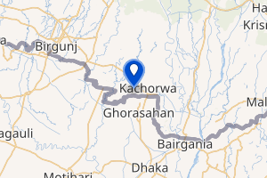
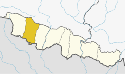
 Simraungadh Location in Nepal 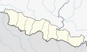 Simraungadh Simraungadh (Province No. 2) | |
| Coordinates: 26°53′22″N 85°7′1″E | |
| Country | Nepal |
| Province | Province No. 2 |
| District | Bara District |
| Government | |
| • Mayor | Bijaya Shankar Yadav (NC) |
| • Deputy Mayor | Rima Devi (RJPN) |
| Area | |
| • Total | 42.65 km2 (16.47 sq mi) |
| Population (2011) | |
| • Total | 49,939 |
| Time zone | UTC+5:45 (NST) |
| Website | www.simraungadhmun.gov.np |
The city finds mention in the travel accounts of a Tibetan monk and pilgrim, Dharmasvamin (1236)[12][13] when he was on his way back to Nepal and Tibet, an Italian Missionary traveler, Cassiano Beligatti (1740),[14][15] Colonel James Kirkpatrick (1801) on his mission to Nepal[16] and later used in 1835 by British ethnologist Brian Houghton Hodgson.[17]
The city is located along the border between India and Nepal. It lies 90 km south of Nepal's capital, Kathmandu, and 28 km east of Birgunj metro city.[18]
Name
The name Simraon comes from the local language Simr which stands for Simal tree found in the area.[19][20] Simraongarh's relationship with the Simal forest has been also revealed by Gopal Raj Vamshavali, the oldest chronicles of Nepal.[21] The Tibetan monk and traveler, Dharmasavamin states Simrāongarh as Pa-ta.[22] The word Pata is an abbreviation of last affix of 'Pattana', which means a capital in Sanskrit language.[22]
History
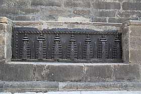
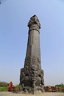
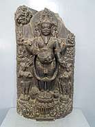
Simraongarh was the capital of an independent Hindu kingdom of the Mithila or Tirhut from the 11th century to early 14th century.[23][24][25][26] The fortified city was built along the present-day border between India and Nepal. The rule of the Karnata dynasty marks an important milestone and a golden age in the history of Tirhut.[27] The rise of this empire saw the birth of efficient administration, social reforms, religious and the development of local folk music and literature.[28][29]
Simraon Dynasty
The Simraon, Karnat or Dev Dynasty originated with establishment of a kingdom in 1097 CE headquartered at present day Simraungadh in Bara District. The kingdom controlled the areas we today know as Tirhut or Mithila in India and Nepal. This region is bounded by the Mahananda River in the east, the Ganges in the south, the Gandaki River in the west and by the Himalayas in the north.[30][31] The boundary line was made between the two countries after the Treaty of Sugauli in 1816.
According to French orientalist and indologist Sylvain Lévi, Nanyadeva established his supremacy over Simraungadh probably with the help of Chalukya king Vikramaditya VI.[32][33][34] After the reign of Vikramaditya VI in 1076 CE, he led the successful military campaign over modern Bengal and Bihar.[35][36]
The rulers of Simraongarh are as follows:
| S.N. | Name of the rulers | Timeline | Notes |
|---|---|---|---|
| 1 | Nanya Dev[17] | 1097 - 1147 CE[4] | |
| 2 | Ganga Dev[17] | 1147 - 1187 CE[4] | |
| 3 | Narsingh Dev[17] | 1187 - 1227 CE[4] | |
| 4 | Ramsingh Dev[17] | 1227 - 1285 CE[4] | |
| 5 | Shaktisingh Dev[17] | 1285 - 1295 CE[4] | |
| 6 | Harisingh Dev[17] | 1295 - 1324 CE[4] |
Invasion
Harisingh Dev (r. 1295 to 1324 CE), the sixth descendant of Nanyadeva was ruling the Tirhut Kingdom. At the same time the Tughlaq dynasty comes to power, which ruled the Delhi sultanate and whole Northern India from 1320 to 1413 CE. In 1324 CE, the founder of the Tughlaq dynasty and Delhi Sultan, Ghiyasuddin Tughlaq turned his attention towards Bengal.[37] The Tughlaq army invaded Bengal and on his way back to Delhi, The sultan heard about the Simraungarh which was flourishing inside the jungle.[38] The last king of the Karnata dynasty Harisingh Dev didn't show his strength and left the fort as he heard the news of approaching army of the Tughlaq Sultan towards the Simraungarh.[39] The Sultan and his troop stayed there for 3 days and cleared the dense forest. Finally on day 3, the army attacked and entered into the huge fort whose walls was tall and surrounded by 7 big ditches.[40]
The remains are still scattered all over the Simroungarh region. The king Harisingh Deva fled northwards into the then Nepal. The son of Harisingh Dev, Jagatsingh Dev married the widow princess of Bhaktapur Nayak Devi.[41] The Gandhavariya Rajputs of North Bihar claim to be the descendants of the Simraon Kings.[42]
Geography and climate
Simraungadh is located at 26°53′22″N 85°7′1″E. It has an average elevation of 83 metres.[43] The Simraungdah town lies on the flat and fertile plain of Terai. In the south, the city borders to Bijwani in the border of the Indian state of Bihar, while Adarsh Kotwal in the north.
References
- Lunden, Staffan (1994). "A Nepalese Labyrinth" (PDF). Caerdroia. 26: 13–21.
- Jha, Makhan (1982). Civilizational Regions of Mithila & Mahakoshal. Capital Publishing House.
- Sinha, Chandreshwar Prasad Narayan (1979). Mithila Under the Karnatas, C. 1097-1325 A.D. Janaki Prakashan.
- Chaudhary, Radhakrishna. Mithilak Itihas [मिथिलाक इतिहास] (in Hindi). Ram Vilas Sahu. pp. 70–112. ISBN 9789380538280.
- Cimino Maria, Rosa (August 1986). "Simraongarh The forgotten city and its art" (PDF). Contribution to Neplaese Studies. 13 (3): 277–288. Retrieved 3 February 2019.
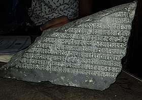
- Garbini, Riccardo (October–November 1993). "A Fragmentary Inscription From Simraongarh, The Ancient Mithila Capital" (PDF). Ancient Nepal (135): 1–9. Retrieved 3 February 2019.
- Magazine, New Spolight. "Nepal government declares 61 new municipalities". SpotlightNepal. Retrieved 2019-02-03.
- "PM formally announces 744 local units operational". My Republica. Archived from the original on 13 August 2018. Retrieved 13 August 2018.
- "स्थानिय तह" [Local Unit]. 103.69.124.141. Archived from the original on 31 August 2018. Retrieved 1 September 2018.
- "Population Ward Level 753 Local Unit" (PDF). CBS. 2 June 2017. Archived (PDF) from the original on 27 January 2018.
- Nepal, Government of Nepal (November 2012). ""National Population and Housing Census 2011 (Village Development Committee/Municipality)" (PDF). National Planning Commission. Archived (PDF) from the original on 21 December 2016.
- Roerich, George Dr. (1959). "Biography Of Dharmasvamin (1959)". K.P. Jayaswal Research Institute: 18.
- Chaudhary P. C. Roy (1964). "Bihar District Gazetteers Darbhanga". Cite journal requires
|journal=(help) - Petech, Luciano (1952). I missionari italiani nel Tibet e nel Nepal (in Italian). Libreria dello Stato. p. 809.
- Ippolito, Desideri (1995). An account of Tibet : the travels of Ippolito Desideri, 1712-1727. New Delhi: Asian Educational Services. pp. 322–323. ISBN 978-8120610194. OCLC 33941427.
- Aitchison.c.u (1910). "The Treaties Amp Relating To Hyderabad Mysore And Coorg". Retrieved 2019-02-03.
- Hodgson, B. H. (1835). "Account of a Visit to the Ruins of Simroun, once the capital of the Mithila province". Journal of the Asiatic Society. 4: 121−124.
- "सिम्रौनगढ : सम्पदा संरक्षणमा चुनौती" [Simraungadh: Challenge in heritage conservation]. Online Khabar (in Nepali). Retrieved 2019-02-10.
- Michael, Bernardo A. (2014-10-01). Statemaking and Territory in South Asia: Lessons from the Anglo–Gorkha War (1814–1816). Anthem Press. ISBN 9781783083220.
- Darnal, Prakash (2018). "A Review of Simraongarh's History on Its Nexus Areas with References of Archeological Evidences". DSAJ: 18–26.
- "सिमरौनगढको सांस्कृतिक सम्पदा" [The cultural heritage of Simraungadh]. eHimalayatimes (in Nepali). Retrieved 2019-02-10.
- Roerich Dr. George. (1959). "Biography Of Dharmasvamin (1959)". Cite journal requires
|journal=(help) - Parishad, Bihar Purāvid (1981). "The Journal of the Bihar Purävid Parishad, Volumes 4-5". p. 414. Retrieved 26 January 2017.
- Choudhary, Radhakrishna (1970). "History of Muslim rule in Tirhut, 1206-1765, A.D." p. 28. Retrieved 26 January 2017.
- Society, Bihar Research (1960). "The Journal of the Bihar Research Society, Volume 46". pp. 22–25. Retrieved 26 January 2017.
- "Publications, Volume 33". 1935. p. 193. Retrieved 26 January 2017.
- "ऐतिहासिक सिम्रौनगढः एक चर्चा" [Historical Simraungadh: A discussion]. Retrieved 2019-02-12.
- Jha, Makhan (1997). Anthropology of Ancient Hindu Kingdoms: A Study in Civilizational Perspective. M.D. Publications Pvt. Ltd. ISBN 9788175330344.
- Chaudhary, Radhakrishna (1976). Mithila In The Age Of Vidyapati (1st ed.). Chaukhambha Orientalia.
- Jha, M. (1997). "Hindu Kingdoms at contextual level". Anthropology of Ancient Hindu Kingdoms: A Study in Civilizational Perspective. New Delhi: M.D. Publications Pvt. Ltd. pp. 27–42.
- Mishra, V. (1979). Cultural Heritage of Mithila. Allahabad: Mithila Prakasana. p. 13.
- Magazine, New Spolight. "Sylvain Lévi's Le Népal". SpotlightNepal. Retrieved 2019-04-15.
- Majumdar, Ramesh Chandra (1957). The Struggle For Empire. Bharatiya Vidya Bhavan, 1957. p. 47.
- Levi, Sylvain (2015-02-18). Le Népal: Étude Historique D'Un Royaume Hindou - Scholar's Choice Edition. Creative Media Partners, LLC. ISBN 9781297173240.
- Somers, George E. (1977). Dynastic History Of Magadha. Abhinav Publications. ISBN 9788170170594.
- Mukherjee, Ramkrishna; Mukherjee, Roopali (1974). Rise and Fall East India. NYU Press. ISBN 9780853453154.
- Choudhary, Radhakrishna (1970). History of Muslim rule in Tirhut, 1206-1765, A.D. Chowkhamba Sanskrit Series Office.
- Thapa, Netra Bahadur (1981). A Short History of Nepal (PDF). Ratna Pustak Bhandar. pp. 38–39.
- Abdusi Akhsatan Dehlavi, Mohammad bin Sadr Taj (1301–1335). "Basatin-Ul Uns". Center for Persian Research: XXI. Cite journal requires
|journal=(help)CS1 maint: date format (link) - Abdul Malik Isami (1981). "Futuh-us-Salatin". University of Madras: 38–39. Cite journal requires
|journal=(help) - "Simroungarh | Nepal | Heritage & Archaeological Site".
- Bindeshwari Prasad Sinha (1974). Comprehensive History Of Bihar Vol.1; Pt.2. Retrieved 8 January 2019.
- "GPS and Latitude". www.gps-coordinates.net. Retrieved 2019-04-16.
External links
| Wikimedia Commons has media related to Simraungadh. |
Headquarter: Kalaiya | ||
| Sub-Metropolitan Cities |
|  |
| Municipalities | ||
| Rural municipalities | ||