Pacharauta
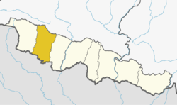
Pacharauta (Nepali: पचरौता ) is a municipality in Bara District in Province No. 2 of South-Eastern Nepal. It was formed in 2016 occupying current 9 sections (wards) from previous 9 former VDCs.[2] It occupies an area of 44.01 km2 with a total population of 34,175.[3][4][1]
Pacharauta पचरौता | |
|---|---|
 Pacharauta Location in Nepal | |
| Coordinates: 26.89°N 85.07°E | |
| Country | Nepal |
| Development Region | Central |
| Zone | Narayani Zone |
| District | Bara District |
| Province | Province No. 2 |
| Government | |
| • Mayor | Ramesh Kumar Yadav |
| • Deputy Mayor | Indu Kumari |
| Area | |
| • Total | 44.01 km2 (16.99 sq mi) |
| Population (2011)[1] | |
| • Total | 34,175 |
| • Density | 780/km2 (2,000/sq mi) |
| • Religions | Hindu, Islam(Muslim), Christian |
| Languages | |
| • Local | Urdu, Bhojpuri, Tharu, Nepali |
| Time zone | UTC+5:45 (NST) |
| Postal Code | 44400 |
| Area code(s) | 053 |
| Website | www.pachrautamun.gov.np |
Farming is the main occupation of the people of this municipality. Some of the people are also involved in government service and small home trade. India (Bihar Boarder) is in the south of this Municipality.
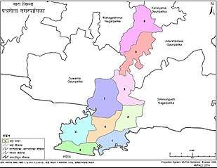
Pachrauta municipality boarder by India with East Champaran of Bihar State in South while in North Adarsh Kotwali Gaupalika, KaraiyaMai Gaupalika and Baragadhi Nagarpalika, in East Adarsh Kotwali Gaupalika and Simraungarh Nagrpalika while in West Suwarn Gaupalika, Mahagadhi Mai and India with East Champaran of Bihar State.
Health
According to Ministry of Health, there are No any health institutions in Pacharauta Municipality.
Municipal Income and Expenditure
Government of Nepal has allocated 363.459 million Nepali Rupees for fiscal year 2017.
It has hot climate with average rainfall of 2 cm. People spend very simple livelihood .It has good progress in the development. According to Census 2011, 8535 households with the population of 40,282; 22,040 males and 18,042 females with an average household size of 4.72. The geographic location of Pachrauta Municipality is 26° 51′ 36″ N, latitude and 85° 4′ 48″ E, longitudes.
The overall literacy rate (for population age 5 years and above) increased from 90.9% in 2017 to 99.5% in 2019. The male literacy rate was 99.3% compared to the female literacy rate of 79.4%. There is one Government School (Shree Nepal Rastiya Secondary School Piparpati) near Piparpati market, where studying up to bachelor's degree in Education (B.Ed), and Intermediate in Education (I.Ed) and also very soon there will be start Science and Mathematics. From last 4 (Four) Years, 2016 in this also a Technical Education class is in the process. This Technical Education class Verify and monitored by CTEVT Nepal. The course start form class 9th to 12th (Full 4 year Computer Engineering Course).
Visit the official webpage of Pachrauta municipality for more details.
| Ward No | VDCs Name | population (2011) | Male | Female | Total Household |
| 1 | Piparpati Pachrauta | 5,033 | 2,541 | 2,492 | 741 |
| 2 | ShriNagar Bairiya | 3,555 | 1,817 | 1,738 | 451 |
| Bisunpur | |||||
| 3 | ShriNagar Bairiya | 2,566 | 1,313 | 1,253 | 375 |
| 4 | Pakadya Chikani | 3,306 | 1,694 | 1,612 | 427 |
| Beldari | |||||
| 5 | Pakadiya chikani | 3,344 | 1,795 | 1,549 | 433 |
| Beldari | |||||
| 6 | Pakadiya chikani | 3,360 | 1,745 | 1,615 | 448 |
| 7 | Benauli | 5,108 | 2,666 | 2,442 | 746 |
| 8 | Amarpatti | 3,738 | 1,874 | 1,864 | 508 |
| 9 | kudawa | 4,163 | 2,093 | 2,070 | 578 |
| Total | 34,173 | 17,538 | 16,635 | 4,707 | |
References
- Nepal, Government of Nepal (November 2012). ""National Population and Housing Census 2011 (Village Development Committee/Municipality)" (PDF). National Planning Commission. Archived from the original (PDF) on 5 October 2018. Retrieved 27 December 2018.
- "PM formally announces 744 local units operational". My Republica. Archived from the original on 13 August 2018. Retrieved 13 August 2018.
- "स्थानिय तह". 103.69.124.141. Archived from the original on 31 August 2018. Retrieved 1 September 2018.
- "Population Ward Level 753 Local Unit" (PDF). CBS. 2 June 2017. Archived from the original (PDF) on 27 January 2018. Retrieved 27 December 2018.
Headquarter: Kalaiya | ||
| Sub-Metropolitan Cities |
|  |
| Municipalities | ||
| Rural municipalities | ||