Simpelveld
Simpelveld (Dutch pronunciation: [ˈsɪmpəlˌvɛlt] (![]()
Simpelveld Zumpelveld | |
|---|---|
 Skyline of Simpelveld | |
 Flag  Coat of arms | |
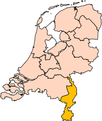
.svg.png) Location in Limburg | |
| Coordinates: 50°50′N 5°59′E | |
| Country | Netherlands |
| Province | Limburg |
| Government | |
| • Body | Municipal council |
| • Mayor | Richard de Boer (VVD) |
| Area | |
| • Total | 16.02 km2 (6.19 sq mi) |
| • Land | 16.02 km2 (6.19 sq mi) |
| • Water | 0.00 km2 (0.00 sq mi) |
| Elevation | 138 m (453 ft) |
| Population (January 2019)[4] | |
| • Total | 10,516 |
| • Density | 656/km2 (1,700/sq mi) |
| Demonym(s) | Simpelvelter |
| Time zone | UTC+1 (CET) |
| • Summer (DST) | UTC+2 (CEST) |
| Postcode | 6350–6353, 6369 |
| Area code | 045 |
| Website | www |
Simpelveld is part of the Mergelland, named after the presence of chalk (mergel), hill country popular with tourists. The Mergellandroute passes through the town.
The population centre of Simpelveld has 28 national monuments, amongst which are the Oude Molen and the Saint Remigius Church. Simpelveld has a heritage railway station and is the home base of the South Limburg Railway Company. On one weekend in October there is a Day out with Thomas from the children's television series Thomas and Friends.
Population centres
- Bocholtz
- Simpelveld
Besides these official centres there are other hamlets which fall under the municipality:
- Baaks-Sweijer
- Baneheide
- Bocholtzerheide
- Bosschenhuizen
- Broek
- Bulkemsbroek
- In de Gaas
- Huls
- Molsberg
- Prickart
- Vlengendaal
- Waalbroek
- Zandberg.

Religion
The municipality has two churches within its borders:
- James the Greater Church in Bocholtz
- Saint Remigius Church in Simpelveld
The city also has two monasteries, these are
- the Loreto monastery and
- Huize Damiaan.
Neither of the monasteries is inhabited.
Regional language
Simpelveld is part of The Netherlands and therefore the official language is Dutch. A lot of people also speak Simpelvelds, a regional language that depending of the definition belongs to Ripuarian or Limburgish. It is also referred to as Southeast Limburgish.
Notable people
- Step Vaessen (born 1965) a Dutch broadcast journalist, currently working as a Moscow correspondent for Al Jazeera English
- Ralph Hamers (born 1966) a Dutch businessman, the chief executive officer (CEO) of ING Group
- Jolanda Jetten (born 1970, Simpelveld) a Dutch social psychologist and academic
See also
Gallery

 Station Simpelveld
 Limburgs, De Boanhei
 Aerial view of Simpelveld
References
- "Burgemeester mr. R. (Richard) de Boer" [Mayor mr. R. (Richard) de Boer] (in Dutch). Gemeente Simpelveld. Retrieved 28 November 2013.
- "Kerncijfers wijken en buurten" [Key figures for neighbourhoods]. CBS Statline (in Dutch). CBS. 2 July 2013. Retrieved 12 March 2014.
- "Postcodetool for 6369AH". Actueel Hoogtebestand Nederland (in Dutch). Het Waterschapshuis. Retrieved 28 November 2013.
- "Bevolkingsontwikkeling; regio per maand" [Population growth; regions per month]. CBS Statline (in Dutch). CBS. 1 January 2019. Retrieved 1 January 2019.
External links

| Wikivoyage has a travel guide for Simpelveld. |
Places adjacent to Simpelveld | ||||||||||
|---|---|---|---|---|---|---|---|---|---|---|
| ||||||||||
| Authority control |
|---|