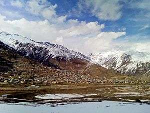
Simikot
Simikot is the administrative headquarters of Humla District of Karnali Zone in the mountain region of northwestern Nepal.
Simikot सिमिकोट | |
|---|---|
District Headquarters | |
 | |
 Simikot Location in Nepal | |
| Coordinates: 29°58′18″N 81°49′15″E | |
| Country | |
| Development Region | Mid-Western |
| Zone | Karnali |
| District | Humla |
| Elevation | 2,910 m (9,550 ft) |
| Time zone | UTC+5:45 (NST) |
| Website | http://simkotmun.gov.np/ |
Transport
Access to Simikot from developed parts of Nepal is mainly by air. Simikot Airport's relatively short 549 metres (1,800 ft) runway at nearly 3,000 metre elevation requires passenger planes with STOL characteristics such as Dornier Do 28 and de Havilland Twin Otter.
Roads from the south have only reached Jumla 86 kilometres (53 mi) to the southeast, however a rough road has been built from the Tibet Autonomous Region border crossing at Hilsa, 51 kilometres (32 mi) WNW
Media
Simikot has two Community radio Stations: Radio Karnali Aawaz at 94.2 MHz and Radio Kailash at 103.4 MHz.
See also
- UN map of Humla District
- Thubron, Colin (2011). To a Mountain in Tibet. New York: Harper Collins. Retrieved Dec 14, 2013.
References
Headquarters: Simikot | ||
| Rural municipalities: | 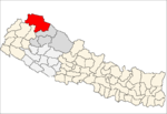 | |
List of municipalities and rural municipalities of Nepal | ||
This article is issued from Wikipedia. The text is licensed under Creative Commons - Attribution - Sharealike. Additional terms may apply for the media files.