Shibata, Niigata
Shibata (新発田市, Shibata-shi) is a city in Niigata Prefecture, Japan. As of 1 July 2019, the city had an estimated population of 95,653 in 36,569 households,[1] and a population density of 179 persons per km². The total area of the city was 533.10 square kilometres (205.83 sq mi).[2]
Shibata 新発田市 | |
|---|---|
 | |
 Flag Seal | |
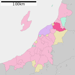 Location of Shibata in Niigata Prefecture | |
 Shibata | |
| Coordinates: 37°56′52.5″N 139°19′38.2″E | |
| Country | Japan |
| Region | Chūbu (Kōshin'etsu) (Hokuriku) |
| Prefecture | Niigata |
| Area | |
| • Total | 533.10 km2 (205.83 sq mi) |
| Population (July 1, 2019) | |
| • Total | 95,653 |
| • Density | 180/km2 (460/sq mi) |
| Time zone | UTC+9 (Japan Standard Time) |
| Symbols | |
| • Tree | Sakura |
| • Flower | Iris |
| Phone number | 0254-22-3030 |
| Address | 3-3-3 Chūōchō, Shibata-shi, Niigata-ken 957-8686 |
| Website | Official website |
.jpg)
Geography
Shibata is located in a mostly inland region of north-central Niigata Prefecture on the northern end of the Echigo Plain, with a small shoreline of the Sea of Japan.
Surrounding municipalities
Climate
Shibata has a Humid climate (Köppen Cfa) characterized by warm, wet summers and cold winters with heavy snowfall. The average annual temperature in Shibata is 13.0 °C. The average annual rainfall is 1920 mm with September as the wettest month. The temperatures are highest on average in August, at around 26.2 °C, and lowest in January, at around 1.2 °C.[3]
Demographics
Per Japanese census data,[4] the population of Shibata has remained relatively steady over the past 40 years.
| Census Year | Population |
|---|---|
| 1970 | 101,245 |
| 1980 | 102,134 |
| 1990 | 104,499 |
| 2000 | 106,016 |
| 2010 | 101,202 |
History
The area of present-day Shibata was part of ancient Echigo Province. The area developed as a castle town for Shibata Domain under the Tokugawa shogunate during the Edo period. After the Meiji restoration, the area was organized into Kitakanbara District, Niigata. The town of Shibata was established on April 1, 1889 with the creation of the modern municipalities system. It was elevated to city status on January 1, 1947. On July 7, 2003 the town of Toyoura (from Kitakanbara District) was merged into Shibata. Likewise, on May 1, 2005 the town of Shiunji, and the village of Kajikawa (both from Kitakanbara District) were merged into Shibata.[2]
Government
Shibata has a mayor-council form of government with a directly elected mayor and a unicameral city legislature of 27 members.
Economy
The economy of Shibata is dominated by the agricultural sector, with rice as the primary crop. Industries include sake brewing and plastics components production.
Education
Shibata has 22 public elementary schools and 10 public junior high schools operated by the city government. The city has seven public high schools operated by the Niigata Prefectural Board of Education, and the prefecture also operates one special education school. Keiwa College is also located in Shibata.
Transportation
Sister city relations
.svg.png)

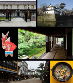
Local attractions
- Shibata Castle (新発田城, Shibata-jō) is the main visitor attraction and provide the backdrop to the spring cherry blossom viewing parties.
- Shimizuen (清水園) Garden
- Ijimino Park (五十公野公園, Ijimino kōen).
- Tsukioka Onsen (月岡温泉) hot spring
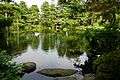 Shimizuen garden
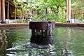 Tsukioka Onsen
References
- Shibata city official statistics(in Japanese)
- Shibata official profile(in Japanese)
- Shibata climate data
- Shibata population statistics
- Prefecture "International Exchange" Check
|url=value (help). List of Affiliation Partners within Prefectures. Council of Local Authorities for International Relations (CLAIR). Retrieved 1 July 2016.
External links
| Wikimedia Commons has media related to Shibata, Niigata. |

- Official Website (in Japanese)
| Wards of Niigata | ||
|---|---|---|
| Special cities | ||
| Cities | ||
| Districts | ||
| Authority control |
|
|---|