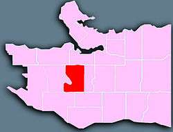
Shaughnessy, Vancouver
Shaughnessy is an almost-entirely residential neighbourhood in Vancouver, British Columbia, Canada, spanning about 447 hectares[1] in a relatively central locale. It is bordered by 16th Avenue to the north, 41st Avenue to the south, Oak Street to the east, and East Boulevard to the west. The older section of the neighbourhood, called "First Shaughnessy," is considered more prestigious and is bordered by 16th Avenue to the north, King Edward Avenue to the south, Cambie Street to the east, and East Boulevard to the west. In 2011, the population was approximately 8,807.[2] It was named after Thomas Shaughnessy, 1st Baron Shaughnessy, former president of the Canadian Pacific Railway.

The neighbourhood's residents have an average annual household income of $105,000 ($777,184 in Shaughnessy Heights) and the average house price is $2.89 million, the highest in Vancouver.[3][4] It is also the site of many historical homes, especially in First Shaughnessy. Of the neighbourhood's homes 51.5% were built before or during World War II, compared with 20.8% for the city at large.[1] This is largely due to the 1981 First Shaughnessy Official Development Plan by-law, which promotes private property ownership and single-family dwelling, while limiting property subdivision and population density.[5]
The neighbourhood was created in 1907 by the Canadian Pacific Railway, the largest real estate developer in Canada. It was meant as an alternative to the West End, which was the traditional home for the budding city's elite.[6] Thanks to aggressive marketing by the railway, highly regulated development, and a stronger degree of exclusiveness, it gradually took the latter's status over the past century. Shaughnessy is known for its elegant tree-lined streets and large properties. In First Shaughnessy, Angus Drive and Osler Street have a tree-lined median in addition to the trees along the edge of the road.
Shaughnessy is home to Little Flower Academy, Vancouver College, and York House School. The public elementary schools are Shaughnessy Elementary and Quilchena Elementary. There is one public high school in Shaughnessy, Point Grey Secondary. The neighbourhood is in the catchment area of each of Eric Hamber Secondary School, in Oakridge, or Prince of Wales Secondary School, in Arbutus Ridge.
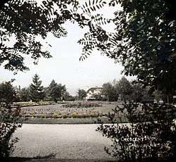
Shaughnessy has five parks, including Shaughnessy Park, formally known as Crescent Park, and Angus Park in First Shaughnessy. The other three parks in Shaughnessy are Devonshire Park, Kerrisdale Park, and VanDusen Botanical Garden, located between 33rd and 41st Avenues. The Arbutus Greenway, purchased by the City of Vancouver from Canadian Pacific Railway, stretches along the western border of Shaughnessy from 41st Avenue to 16th Avenue.[7]
References
- "Community Statistics Census Data: Shaughnessy" (PDF). 2001. Archived from the original (PDF) on 2007-09-30. Retrieved 2007-07-09.
- "Archived copy". Archived from the original on 2016-03-04. Retrieved 2015-11-04.CS1 maint: archived copy as title (link)
- "Archived copy". Archived from the original on 2015-04-02. Retrieved 2015-03-24.CS1 maint: archived copy as title (link)
- http://vancouver.ca/files/cov/Shaughnessy-census-data.pdf
- "First Shaughnessy Official Development Plan" (PDF) (Press release). City of Vancouver. 1998-04-01. Retrieved 2007-07-09.
- "Walking Tour: Shaughnessy". 2003-06-03. Retrieved 2007-07-09.
- "City of Vancouver buys Arbutus Corridor for $55 million". Vancity Buzz. 2016-03-07. Retrieved 2017-04-29.
Sources
- Alexander, D. (1998). Learning from Shaughnessy: The role of design guidelines in adjudicating community conflicts. Vancouver: Social Change Institute. Retrieved from VIUSpace