Selam (Dogu'a Tembien)
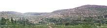
Selam is a tabia or municipality in the Dogu'a Tembien district of the Tigray Region of Ethiopia. The tabia centre is in Addi Werho village, located approximately 3 km to the northeast of the woreda town Hagere Selam.
Selam | |
|---|---|
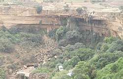 Tinsehe waterfall | |
 Selam Location within Ethiopia | |
| Coordinates: 13°40′N 39°12′E | |
| Country | Ethiopia |
| Region | Tigray |
| Zone | Debub Misraqawi (Southeastern) |
| Woreda | Dogu'a Tembien |
| Area | |
| • Total | 17.77 km2 (6.86 sq mi) |
| Elevation | 2,400 m (7,900 ft) |
| Population (2007) | |
| • Total | 3,855 |
| • Density | 217/km2 (560/sq mi) |
| Time zone | UTC+3 (EAT) |
Geography
The tabia stretches down north of the ridge occupied by the main road towards the Tinsehe gorge. The highest peak is Imba Khoboro (2730 m a.s.l.) and the lowest place at the foot of the waterfall in Tinsehe (2000 m a.s.l.).
Geology
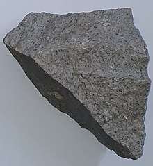
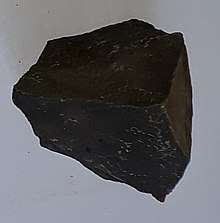
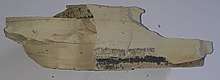
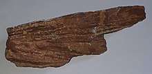
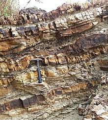
From the higher to the lower locations, the following geological formations are present:[1]
Geomorphology and soils
The main geomorphic units, with corresponding soil types are:[3]
Hagere Selam Highlands, along the upper basalt and sandstone ridge
- Associated soil types
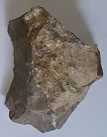
_Thapto_Haplic_Leptosol_at_Mere'a_Ziban_Ethiopia.jpg)
- deep, dark cracking clays, temporarily waterlogged during the wet season (Pellic Vertisol)
- Inclusions
- Rock outcrops and very shallow soils (Lithic Leptosol)
- Rock outcrops and very shallow soils on limestone (Calcaric Leptosol)
- Deep dark cracking clays with very good natural fertility, waterlogged during the wet season (Chromic Vertisol, Pellic Vertisol)
- Shallow stony dark loams on calcaric material (Calcaric Regosol, Calcaric Cambisol)
- Brown loamy soils on basalt with good natural fertility (Luvisol)
Gently rolling Antalo Limestone plateau (in the lower parts), holding cliffs and valley bottoms on limestone
- Associated soil types
- Inclusions
- Rock outcrops and very shallow soils (Lithic Leptosol)
- Shallow very stony loamy soil on limestone (Skeletic Calcaric Cambisol)
- Deep dark cracking clays with very good natural fertility, waterlogged during the wet season (Chromic Vertisol, Pellic Vertisol)
- Brown to dark sands and silt loams on alluvium (Vertic Fluvisol, Eutric Fluvisol, Haplic Fluvisol)
Climate and hydrology
Climate and meteorology
The rainfall pattern shows a very high seasonality with 70 to 80% of the annual rain falling in July and August. Mean temperature in Addi Werho is 18.8 °C, oscillating between average daily minimum of 10.5 °C and maximum of 26.7 °C. The contrasts between day and night air temperatures are much larger than seasonal contrasts.[4]
Rivers
The Tsaliet River (a tributary to Weri’i River) is the most important rivers in the surroundings of the tabia. They flow towards Tekezze River and further on to the Nile. These rivers have incised deep gorges which characterise the landscape.[5] The drainage network of the tabia is organised as follows:[6]
- Weri’i River basin
- May Leiba, in tabia Ayninbirkekin, which becomes Tinsehe R. in Selam and Mahbere Sillasie, and Tsaliet River, downstream from the Dabba Selama monastery
- May Meqa River, in tabia Selam
- Harehuwa River, in tabia Mahbere Sillasie
- May Leiba, in tabia Ayninbirkekin, which becomes Tinsehe R. in Selam and Mahbere Sillasie, and Tsaliet River, downstream from the Dabba Selama monastery
Whereas they are (nearly) dry during most of the year, during the main rainy season, these rivers carry high runoff discharges, sometimes in the form of flash floods. Especially at the begin of the rainy season they are brown-coloured, evidencing high soil erosion rates.
Springs
As there are no permanent rivers, the presence of springs is of utmost importance for the local people. The main springs in the tabia are:[7]
- May Gudgwad in Khunale
- May Miheno in Miheno
Water harvesting
In this area with rains that last only for a couple of months per year, reservoirs of different sizes allow harvesting runoff from the rainy season for further use in the dry season. Overall they suffer from siltation.[8] Yet, they strongly contribute to greening the landscape, either through irrigation or seepage water. Main reservoirs are:
- Traditional surface water harvesting ponds, particularly in places without permanent springs, called rahaya
- Horoyo, household ponds, recently constructed through campaigns[9]
Settlements
The tabia centre Addi Worho holds a few administrative offices, a health post, a primary school, and some small shops.[7] There are a few more primary schools across the tabia. The main other populated places are:[6]
- Khunale
- Addi Amyuq (on the boundary to Mahbere Sillasie)
- Miheno
- Tinsehe
Vegetation and exclosures
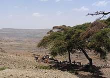
The tabia holds several exclosures, areas that are set aside for regreening,[10] such as Khunale exclosure. Wood harvesting and livestock range are not allowed there. Besides effects on biodiversity,[11][12][13] water infiltration, protection from flooding, sediment deposition,[14] carbon sequestration,[15] people commonly have economic benefits from these exclosures through grass harvesting, beekeeping and other non-timber forest products.[16] The local inhabitants also consider it as “land set aside for future generations”.[17]
Agriculture and livelihood
Agriculture
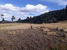
The population lives essentially from crop farming, supplemented with off-season work in nearby towns. The land is dominated by farmlands which are clearly demarcated and are cropped every year. Hence the agricultural system is a permanent upland farming system.[18] The farmers have adapted their cropping systems to the spatio-temporal variability in rainfall.[19]
Schools
Almost all children of the tabia are schooled,[20] though in some schools there is lack of classrooms, directly related to the large intake in primary schools over the last decades.[21] Schools in the tabia include Khunale school.
History and culture
History
The history of the tabia is strongly confounded with the history of Tembien.
Religion and churches
Most inhabitants are Orthodox Christians. The following churches are located in the tabia:
- Arba’ite Insesa
- Abune Kiros
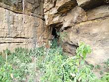
- Kidane Mihret, at the foot of, and partly under Tinsehe’s waterfall, in a forested cove
Roads and communication
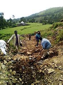
The main road Mekelle – Hagere Selam – Abiy Addi runs at the southern edge of the tabia. There are regular bus services to these towns. Further, a rural access road links Tinsehe and Addi Werho to the main asphalt road.
Tourism
Its mountainous nature and proximity to Mekelle make the tabia fit for tourism.[22] As compared to many other mountain areas in Ethiopia the villages are quite accessible, and during walks visitors may be invited for coffee, lunch or even for an overnight stay in a rural homestead.[23]
Touristic attractions
- Tinsehe waterfall
Geotouristic sites
The high variability of geological formations and the rugged topography invite for geological and geographic tourism or "geotourism".[24] Geosites in the tabia include:
- Ksad Addi Amyuq roadcut with exposed interbedded lacustrine deposits
- Views from Imba Zuw’ala
- Khunale exclosure
- Phonolite plug at Imba Khoboro
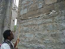
- Church built with phonolite stone in Khunale Arba’ite Insesa
- Meri’a Ziban hill in interbedded lacustrine deposits
Birdwatching
Birdwatching (for the species, see the main Dogu'a Tembien page) can be done particularly in the tropical forest at the foot of the Tinsehe waterfall. [25][6]
Trekking routes
Trekking routes have been established in this tabia.[26] The tracks are not marked on the ground but can be followed using downloaded .GPX files.[27]
- Trek 2, crosses the tabia from north (Khunale) to South (Tinsehe Waterfall)
- Trek 14, from west to east along the upper ridge at the southern side of the tabia
- Trek 23, from the main road in Miheno, downslope to Addi Idaga
See also
- Dogu'a Tembien district.
References
- Sembroni, A.; Molin, P.; Dramis, F. (2019). Regional geology of the Dogu'a Tembien massif. In: Geo-trekking in Ethiopia's Tropical Mountains — The Dogu'a Tembien District. SpringerNature. ISBN 978-3-030-04954-6.
- Moeyersons, J. and colleagues (2006). "Age and backfill/overfill stratigraphy of two tufa dams, Tigray Highlands, Ethiopia: Evidence for Late Pleistocene and Holocene wet conditions". Palaeogeography, Palaeoclimatology, Palaeoecology. 230 (1–2): 162–178. Bibcode:2006PPP...230..165M. doi:10.1016/j.palaeo.2005.07.013.
- Nyssen, Jan; Tielens, Sander; Gebreyohannes, Tesfamichael; Araya, Tigist; Teka, Kassa; Van De Wauw, Johan; Degeyndt, Karen; Descheemaeker, Katrien; Amare, Kassa; Haile, Mitiku; Zenebe, Amanuel; Munro, Neil; Walraevens, Kristine; Gebrehiwot, Kindeya; Poesen, Jean; Frankl, Amaury; Tsegay, Alemtsehay; Deckers, Jozef (2019). "Understanding spatial patterns of soils for sustainable agriculture in northern Ethiopia's tropical mountains". PLOS ONE. 14 (10): e0224041. doi:10.1371/journal.pone.0224041. PMC 6804989. PMID 31639144.
- Jacob, M. and colleagues (2019). Dogu'a Tembien's Tropical Mountain Climate. In: Geo-trekking in Ethiopia's Tropical Mountains — The Dogu'a Tembien District. SpringerNature. doi:10.1007/978-3-030-04955-3_3. ISBN 978-3-030-04954-6.
- Amanuel Zenebe, and colleagues (2019). The Giba, Tanqwa and Tsaliet rivers in the headwaters of the Tekezze basin. In: Geo-trekking in Ethiopia's Tropical Mountains — The Dogu'a Tembien District. SpringerNature. doi:10.1007/978-3-030-04955-3_14. ISBN 978-3-030-04954-6.
- Jacob, M. and colleagues (2019). Geo-trekking map of Dogu'a Tembien (1:50,000). In: Geo-trekking in Ethiopia's Tropical Mountains — The Dogu'a Tembien District. SpringerNature. ISBN 978-3-030-04954-6.
- What do we hear from the farmers in Dogu'a Tembien? [in Tigrinya]. Hagere Selam, Ethiopia. 2016. p. 100.
- Nigussie Haregeweyn, and colleagues (2006). "Reservoirs in Tigray: characteristics and sediment deposition problems". Land Degradation and Development. 17: 211–230. doi:10.1002/ldr.698.
- Developers and farmers intertwining interventions: the case of rainwater harvesting and food-for-work in Degua Temben, Tigray, Ethiopia
- Aerts, R; Nyssen, J; Mitiku Haile (2009). "On the difference between "exclosures" and "enclosures" in ecology and the environment". Journal of Arid Environments. 73 (8): 762–763. doi:10.1016/j.jaridenv.2009.01.006.
- Aerts, R.; Lerouge, F.; November, E. (2019). Birds of forests and open woodlands in the highlands of Dogu'a Tembien. In: Geo-trekking in Ethiopia's Tropical Mountains - The Dogu'a Tembien District. SpringerNature. ISBN 978-3-030-04954-6.
- Mastewal Yami, and colleagues (2007). "Impact of Area Enclosures on Density and Diversity of Large Wild Mammals: The Case of May Ba'ati, Douga Tembien Woreda, Central Tigray, Ethiopia". East African Journal of Sciences. 1: 1–14.
- Aerts, R; Lerouge, F; November, E; Lens, L; Hermy, M; Muys, B (2008). "Land rehabilitation and the conservation of birds in a degraded Afromontane landscape in northern Ethiopia". Biodiversity and Conservation. 17: 53–69. doi:10.1007/s10531-007-9230-2.
- Descheemaeker, K. and colleagues (2006). "Sediment deposition and pedogenesis in exclosures in the Tigray Highlands, Ethiopia". Geoderma. 132 (3–4): 291–314. doi:10.1016/j.geoderma.2005.04.027.
- Wolde Mekuria, and colleagues (2011). "Restoration of Ecosystem Carbon Stocks Following Exclosure Establishment in Communal Grazing Lands in Tigray, Ethiopia". Soil Science Society of America Journal. 75 (1): 246–256. doi:10.2136/sssaj2010.0176.
- Bedru Babulo, and colleagues (2006). "Economic valuation methods of forest rehabilitation in exclosures". Journal of the Drylands. 1: 165–170.
- Jacob, M. and colleagues (2019). Exclosures as Primary Option for Reforestation in Dogu'a Tembien. In: Geo-trekking in Ethiopia's Tropical Mountains - The Dogu'a Tembien District. SpringerNature. ISBN 978-3-030-04954-6.
- Nyssen, J.; Naudts, J.; De Geyndt, K.; Haile, Mitiku; Poesen, J.; Moeyersons, J.; Deckers, J. (2008). "Soils and land use in the Tigray highlands (Northern Ethiopia)". Land Degradation and Development. 19 (3): 257–274. doi:10.1002/ldr.840.
- Frankl, A. and colleagues (2013). "The effect of rainfall on spatio‐temporal variability in cropping systems and duration of crop cover in the Northern Ethiopian Highlands". Soil Use and Management. 29 (3): 374–383. doi:10.1111/sum.12041.
- Socio-demographic profile, food insecurity and food-aid based response. In: Geo-trekking in Ethiopia's Tropical Mountains - The Dogu'a Tembien District. SpringerNature. 2019. ISBN 978-3-030-04954-6.
- Hartjen, C.A. and Priyadarsini, S., 2012. Denial of Education. In The Global Victimization of Children (pp. 271-321). Springer, Boston, MA. https://link.springer.com/chapter/10.1007/978-1-4614-2179-5_8 .
- Geo-trekking in Ethiopia's Tropical Mountains — The Dogu'a Tembien District. GeoGuide. SpringerNature. 2019. ISBN 978-3-030-04954-6.
- Nyssen, Jan (2019). "Logistics for the Trekker in a Rural Mountain District of Northern Ethiopia". Geo-trekking in Ethiopia's Tropical Mountains. GeoGuide. Springer-Nature. pp. 537–556. doi:10.1007/978-3-030-04955-3_37. ISBN 978-3-030-04954-6.
- Miruts Hagos and colleagues (2019). Geosites, Geoheritage, Human-Environment Interactions, and Sustainable Geotourism in Dogu'a Tembien. In: Geo-Trekking in Ethiopia's Tropical Mountains, the Dogu'a Tembien District. SpringerNature. doi:10.1007/978-3-030-04955-3_1. ISBN 978-3-030-04954-6.
- Aerts, R.; Lerouge, F.; November, E. (2019). Birds of forests and open woodlands in the highlands of Dogu'a Tembien. In: Geo-trekking in Ethiopia's Tropical Mountains – The Dogu'a Tembien District. SpringerNature. ISBN 978-3-030-04954-6.
- Nyssen, Jan (2019). Description of Trekking Routes in Dogu'a Tembien. GeoGuide. Springer-Nature. pp. 557–675. doi:10.1007/978-3-030-04955-3_38. ISBN 978-3-030-04954-6.
- "Public GPS traces tagged with nyssen-jacob-frankl". OpenStreetMap. Retrieved 2019-10-11.
Places adjacent to Selam (Dogu'a Tembien) | |
|---|---|