Scott, New York
Scott is a town in Cortland County, New York, United States. The population was 1,176 at the 2010 census.[3] The town was named after General Winfield Scott. It is in the northwest corner of Cortland County and is northwest of Cortland.
Scott, New York | |
|---|---|
Town | |
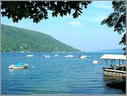 Skaneateles Lake marina, hamlet of Fair Haven | |
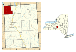 Location within Cortland County and New York | |
 Scott Location in the United States  Scott Scott (New York) | |
| Coordinates: 42°43′46″N 76°13′54″W | |
| Country | United States |
| State | New York |
| County | Cortland |
| Government | |
| • Type | Town Council |
| • Town Supervisor | Kevin J. Fitch (R) |
| • Town Council | Members' List
|
| Area | |
| • Total | 22.39 sq mi (57.99 km2) |
| • Land | 22.24 sq mi (57.61 km2) |
| • Water | 0.15 sq mi (0.38 km2) |
| Elevation | 1,795 ft (547 m) |
| Population (2010) | |
| • Total | 1,176 |
| • Estimate (2016)[2] | 1,139 |
| • Density | 51.21/sq mi (19.77/km2) |
| Time zone | UTC-5 (Eastern (EST)) |
| • Summer (DST) | UTC-4 (EDT) |
| ZIP code | 13077 |
| Area code(s) | 607 |
| FIPS code | 36-023-65915 |
| GNIS feature ID | 0979477 |
| Website | www |
History
Scott is within the former Central New York Military Tract. The first white settler arrived around 1799.
The town was formed in 1815 from the town of Preble. The population in 1865 was 1,149.
The town is the birthplace of James Henry Salisbury, who later went on to create the Salisbury Steak.[4]
Geography
According to the United States Census Bureau, the town has a total area of 22.4 square miles (58.1 km2), of which 22.3 square miles (57.7 km2) is land and 0.15 square miles (0.4 km2), or 0.65%, is water.[3]
The west town line is the border of Cayuga County, and the north town line is the border of Onondaga County. New York State Route 41 is a north-south highway in Scott.
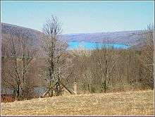
The south end of Skaneateles Lake, one of the Finger Lakes, is in the northwest part of the town. Grout Brook, a noted trout-fishing stream, flows into the lake from the town. The hamlet of Fair Haven in the town of Scott, together with adjoining Glen Haven in the town of Niles and Spafford Landing in the town of Spafford, comprise a scenic destination for visitors as well as an attractive community for residents. Lodging and dining facilities are available, together with docking and a marina (below).
The eastern two-thirds of town drains southward via Cold Brook and Factory Brook to the West Branch of the Tioughnioga River, part of the Susquehanna River watershed.
Demographics
| Historical population | |||
|---|---|---|---|
| Census | Pop. | %± | |
| 1820 | 775 | — | |
| 1830 | 1,452 | 87.4% | |
| 1840 | 1,368 | −5.8% | |
| 1850 | 1,293 | −5.5% | |
| 1860 | 1,211 | −6.3% | |
| 1870 | 1,083 | −10.6% | |
| 1880 | 980 | −9.5% | |
| 1890 | 987 | 0.7% | |
| 1900 | 852 | −13.7% | |
| 1910 | 718 | −15.7% | |
| 1920 | 625 | −13.0% | |
| 1930 | 544 | −13.0% | |
| 1940 | 535 | −1.7% | |
| 1950 | 527 | −1.5% | |
| 1960 | 600 | 13.9% | |
| 1970 | 805 | 34.2% | |
| 1980 | 1,193 | 48.2% | |
| 1990 | 1,167 | −2.2% | |
| 2000 | 1,193 | 2.2% | |
| 2010 | 1,176 | −1.4% | |
| Est. 2016 | 1,139 | [2] | −3.1% |
| U.S. Decennial Census[5] | |||
As of the census[6] of 2000, there were 1,193 people, 417 households, and 321 families residing in the town. The population density was 53.6 people per square mile (20.7/km²). There were 478 housing units at an average density of 21.5 per square mile (8.3/km²). The racial makeup of the town was 98.32% White, 0.08% African American, 0.42% Native American, 0.34% Asian, and 0.84% from two or more races. Hispanic or Latino of any race were 0.17% of the population.
There were 417 households out of which 41.7% had children under the age of 18 living with them, 64.7% were married couples living together, 7.4% had a female householder with no husband present, and 22.8% were non-families. 15.6% of all households were made up of individuals and 7.0% had someone living alone who was 65 years of age or older. The average household size was 2.86 and the average family size was 3.18.
In the town, the population was spread out with 29.9% under the age of 18, 7.5% from 18 to 24, 31.3% from 25 to 44, 23.3% from 45 to 64, and 8.0% who were 65 years of age or older. The median age was 36 years. For every 100 females, there were 102.9 males. For every 100 females age 18 and over, there were 101.0 males.
The median income for a household in the town was $39,000, and the median income for a family was $43,438. Males had a median income of $32,313 versus $20,817 for females. The per capita income for the town was $15,588. About 7.7% of families and 9.9% of the population were below the poverty line, including 9.8% of those under age 18 and 4.0% of those age 65 or over.
Communities and locations in Scott
- East Scott – A hamlet by the east town line on County Road 102.
- Fair Haven – A hamlet on the east shore of Skaneateles Lake by the north town line. Distinct from Glen Haven on the west side of the lake in the town of Sempronius. The Glen Haven District No. 4 School and Public Library was listed on the National Register of Historic Places in 1997.[7]
- Grout Mill – A hamlet about one mile west of Scott village and close to the west town line.
- Scott – The hamlet of Scott on Route 41 at the intersection of County Road 101. It was formerly called "Scott Center".
References
- "2016 U.S. Gazetteer Files". United States Census Bureau. Retrieved Jul 4, 2017.
- "Population and Housing Unit Estimates". Retrieved June 9, 2017.
- "Geographic Identifiers: 2010 Demographic Profile Data (G001): Scott town, Cortland County, New York". U.S. Census Bureau, American Factfinder. Archived from the original on February 12, 2020. Retrieved December 16, 2014.
- Clemens, Chris (2019-05-02). "The History of Salisbury Steak and Central New York |". Exploring Upstate. Retrieved 2019-05-02.
- "Census of Population and Housing". Census.gov. Retrieved June 4, 2015.
- "U.S. Census website". United States Census Bureau. Retrieved 2008-01-31.
- "National Register Information System". National Register of Historic Places. National Park Service. July 9, 2010.
External links
Municipalities and communities of Cortland County, New York, United States | ||
|---|---|---|
| City |  Map of New York highlighting Cortland County | |
| Towns | ||
| Villages | ||
| CDPs | ||
| Hamlets | ||