Schönwald, Brandenburg
Schönwald is a municipality in the district of Dahme-Spreewald in Brandenburg in Germany.
Schönwald | |
|---|---|
Location of Schönwald within Dahme-Spreewald district 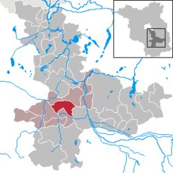 | |
 Schönwald  Schönwald | |
| Coordinates: 51°58′59″N 13°41′59″E | |
| Country | Germany |
| State | Brandenburg |
| District | Dahme-Spreewald |
| Municipal assoc. | Unterspreewald |
| Subdivisions | 2 Ortsteile |
| Government | |
| • Mayor | Roland Gefreiter |
| Area | |
| • Total | 44.85 km2 (17.32 sq mi) |
| Elevation | 53 m (174 ft) |
| Population (2018-12-31)[1] | |
| • Total | 1,162 |
| • Density | 26/km2 (67/sq mi) |
| Time zone | CET/CEST (UTC+1/+2) |
| Postal codes | 15910 |
| Dialling codes | 035474 |
| Vehicle registration | LDS |
| Website | www.unterspreewald.de |
History
The present Schönwald as an entity was created from the voluntary merger of two previously independent municipalities, Schönwalde (Lower Sorbian Běły Gózd) und Waldow-Brand. Today it is in the jurisdiction of the district of Unterspreewald, the seat of which is itself in Schönwald.
Demography
.pdf.jpg)
Development of population since 1875 within the current boundaries (Blue line: Population; Dotted line: Comparison to population development of Brandenburg state; Grey background: Time of Nazi rule; Red background: Time of communist rule)
| Schönwald: Population development within the current boundaries (2017)[2] | ||||||||||||||||||||||||||||||||||||||||||||||||||||||||||||||||||||||||||||||||||||||||||||||||||||||||||||||||||||||||||||||||||||||
|---|---|---|---|---|---|---|---|---|---|---|---|---|---|---|---|---|---|---|---|---|---|---|---|---|---|---|---|---|---|---|---|---|---|---|---|---|---|---|---|---|---|---|---|---|---|---|---|---|---|---|---|---|---|---|---|---|---|---|---|---|---|---|---|---|---|---|---|---|---|---|---|---|---|---|---|---|---|---|---|---|---|---|---|---|---|---|---|---|---|---|---|---|---|---|---|---|---|---|---|---|---|---|---|---|---|---|---|---|---|---|---|---|---|---|---|---|---|---|---|---|---|---|---|---|---|---|---|---|---|---|---|---|---|---|
|
|
| ||||||||||||||||||||||||||||||||||||||||||||||||||||||||||||||||||||||||||||||||||||||||||||||||||||||||||||||||||||||||||||||||||||
References
- "Bevölkerung im Land Brandenburg nach amtsfreien Gemeinden, Ämtern und Gemeinden 31. Dezember 2018". Amt für Statistik Berlin-Brandenburg (in German). July 2019.
- Detailed data sources are to be found in the Wikimedia Commons.Population Projection Brandenburg at Wikimedia Commons
This article is issued from Wikipedia. The text is licensed under Creative Commons - Attribution - Sharealike. Additional terms may apply for the media files.