Sarychev Peak
Sarychev Peak (Russian: вулкан Пик Сарычева, Vulkan Sarycheva, variants: Japanese: 芙蓉山 Fuyō Mountain, [1] Fuyō-san, [2] Fuyō-yama, [3] Fuyo-zan, [4] Huyō San, Japanese: 松輪富士 Matsuwa-fuji), [5] is a stratovolcano covering almost the entirety of Matua Island in the Kuril Islands, Russia. It is a young, highly symmetrical stratovolcanic cone.
| Sarychev Peak | |
|---|---|
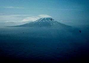 Sarychev Peak on Matua Island, looking south from Raikoke. | |
| Highest point | |
| Elevation | 1,496 m (4,908 ft) |
| Prominence | 1,496 m (4,908 ft) |
| Coordinates | 48.092°N 153.20°E |
| Geography | |
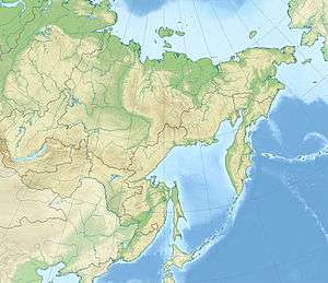 Sarychev Peak Sarychev Peak in Russian Far East | |
| Location | Matua, Kuril Islands, Russia |
| Geology | |
| Mountain type | Stratovolcano |
| Last eruption | 2019 |
History
The peak was named after admiral Gavril Sarychev of the Imperial Russian Navy.
2009 eruption
The volcano erupted June 11–21, 2009,[6][7] sending out ash plumes.[8] As the volcano is near some of the main air routes between East Asia and North America, there was some disruption to air traffic.[9]
During an early stage of the eruption, on June 12, 2009, the International Space Station passed overhead and astronauts photographed the event.[10] A hole in the overhead clouds, possibly caused by the shock wave from the explosion, allowed a clear view of the plume and pyroclastic flow down the sides of the mountain. A cap-like pileus cloud is visible atop the rising column.[10]
Sarychev Peak previously erupted in 1760, 1805, 1879, 1923, 1927, 1928, 1930, 1932, 1946, 1954, 1960, 1965, 1976, 1986 and 1989.[6]
Gallery
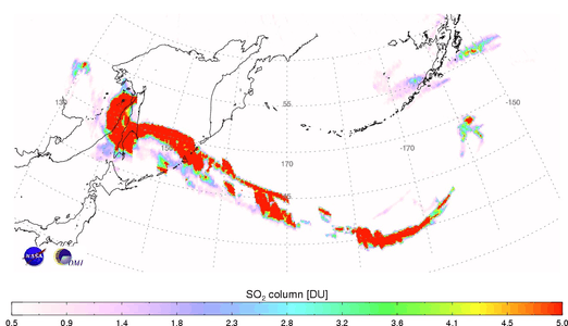 The Sulphur Dioxide cloud generated by the eruption on 12 June 2009 (in Dobson units).
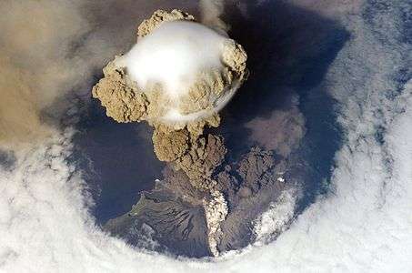 Sarychev Peak Volcano erupts June 12, 2009, 22:16:14.
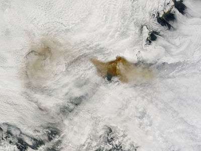 Sarychev Peak, June 14, 2009, 1:05 p.m.
 Sarychev Peak, June 14, 2009, 2:50 p.m.
 Sarychev Peak, June 15, 2009, 1:45 p.m.
 Sarychev Peak, June 15, 2009, 3:35 p.m.
See also
References
- "Fuyō Mountain: Russia, in Geographic.org". Retrieved 2010-08-12.
- "Fuyō-san: Russia, in Geographic.org". Retrieved 2010-08-12.
- "Fuyō-yama: Russia, in Geographic.org". Retrieved 2010-08-12.
- "Fuyō-zan: Russia in Geographic.org". Retrieved 2010-08-12.
- "Huyō San: Russia in Geographic.org". Retrieved 2010-08-12.
- "Global Volcanism Program | Sarychev Peak". volcano.si.edu. Retrieved 2016-12-05.
- "Sarychev Peak". www.volcanodiscovery.com. Retrieved 2016-12-05.
- "Activity at Sarychev Peak". NASA Earth Observatory.
- Air Canada (2009-06-15). "Travel Advisory For Flights to and from Vancouver and Tokyo, Seoul, Beijing, Shanghai and Hong Kong". Retrieved 2009-06-15.
- "Sarychev Peak Eruption, Kuril Islands". NASA Earth Observatory. June 22, 2009.
External links
| Wikimedia Commons has media related to Sarychev Peak. |
| Islands | |
|---|---|
| Volcanoes |
|
| Other geographical features | |
| Cities and towns | |
| Events | |
| People | |