Sar Mashhad
Sar Mashhad (Persian: سرمشهد; also known as Sar Meshad)[1] is a village in Dadin Rural District, Jereh and Baladeh District, Kazerun County, Fars Province, Iran. At the 2012 census, its population was 3,047, in 623 families.[2]
Sar Mashhad سرمشهد | |
|---|---|
village | |
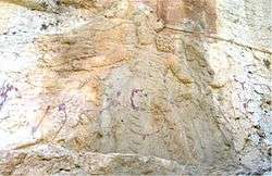 Rock relief of Bahram II at Sar Mashhad | |
 Sar Mashhad | |
| Coordinates: 29°17′28″N 51°42′13″E | |
| Country | |
| Province | Fars |
| County | Kazerun |
| Bakhsh | Jereh and Baladeh |
| Rural District | Dadin |
| Population (2016) | |
| • Total | 3,047 |
| Time zone | UTC+3:30 (IRST) |
| • Summer (DST) | UTC+4:30 (IRDT) |
The place is notable for being the site of a Sasanian rock relief made during the reign of king (shah) Bahram II (r. 274–293).[3] The relief portrays him as a hunter who has slayed a lion whilst throwing his sword at another.[3] His wife is holding his right hand in a signal of safeguard, whilst the high priest Kartir and another figure, most likely a prince, are watching.[3] The scenery has been the subject of several symbolic and metaphorical meanings, thought it is most likely supposed to portray a simple royal display of braveness during a real-life hunt.[3] An inscription of Kartir is underneath the relief.[3]
References
- Sar Mashhad can be found at GEOnet Names Server, at this link, by opening the Advanced Search box, entering "-3082934" in the "Unique Feature Id" form, and clicking on "Search Database".
- "Census of the Islamic Republic of Iran, 1395 (2016)" (Excel). Islamic Republic of Iran.
- Shahbazi 1988, pp. 514-522.
Sources
- Shahbazi, A. Shapur (1988). "Bahrām II". Encyclopaedia Iranica, Vol. III, Fasc. 5. pp. 514–522.CS1 maint: ref=harv (link)