Santa Cruz River (Arizona)
The Santa Cruz River (Spanish: Río Santa Cruz "Holy Cross River") is a tributary river to the Gila River in Southern Arizona and northern Sonora, Mexico. It is approximately 184 miles (296 km) long.[1]
| Santa Cruz River | |
|---|---|
 The Santa Cruz River near Red Rock. | |
 | |
| Location | |
| Countries | United States, Mexico |
| States | Arizona, Sonora |
| Physical characteristics | |
| Source | |
| • location | San Rafael Valley |
| Mouth | |
• location | Gila River |
| Length | 184 miles (296 km) |
Course
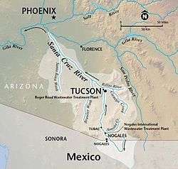
The Santa Cruz has its headwaters in the high intermontane grasslands of the San Rafael Valley to the southeast of Patagonia, Arizona, between the Canelo Hills to the east and the Patagonia Mountains to the west, just north of the international border. It flows southward into Mexico past Santa Cruz, Sonora and turns westward around the south end of the Sierra San Antonio near Miguel Hidalgo (San Lázaro), thence north-northwest to reenter the United States just to the east of Nogales and southwest of Kino Springs. It then continues northward from the international border past the Tumacacori National Historical Park, Tubac, Green Valley, Sahuarita, San Xavier del Bac, Tucson, Marana, and Picacho Peak State Park to the Santa Cruz Flats just to the south of Casa Grande and the Gila River. Between Nogales and Tucson the river valley is flanked by the San Cayetano and Santa Rita Mountains on the east and the Atascosa, Tumacacori, and Sierrita Mountains on the west.
Hydrography
Most of the Santa Cruz River is usually a dry riverbed, unless the area receives significant rainfall. This was not always the case, but a combination of human errors and natural catastrophes in the late nineteenth century led to the decline of the Santa Cruz.[2]
The city of Nogales, Sonora, has been releasing treated sewage into the Santa Cruz River. This has resulted in the revival of several miles of riverbank within and north of the city of Nogales, Arizona.[3]
The Juan Bautista de Anza National Historic Trail parallels much of the Santa Cruz. In Marana, there are approximately ten paved miles of multi-use recreational path along the Santa Cruz, located on Tangerine Road and through the Gladden Farms community park.
Gallery
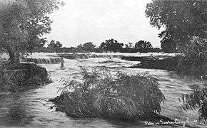 Little waterfalls along the Santa Cruz River in downtown Tucson in 1889.
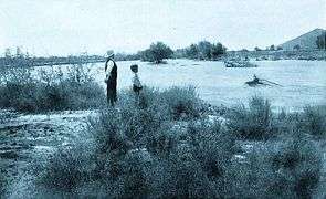 The Santa Cruz during a flood, c.1903.
 View of the Santa Cruz from "A" Mountain in 1904. Notice the riparian gallery forest, which has since become extinct.
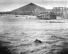 A wrecked bridge along the Santa Cruz during the flood of 1915. "A" Mountain is in the background.
.jpg) A view of the Santa Cruz south of Tucson, facing south. The Santa Rita Mountains are in the background.
A view of the Santa Cruz south of Tucson, facing south. The Santa Rita Mountains are in the background.
References
- "The National Map". U.S. Geological Survey. Retrieved March 8, 2011.
- THE DECLINE OF THE SANTA CRUZ RIVER
- Tucson Citizen: Who will save the Santa Cruz Archived 2012-07-16 at Archive.today
External links
- Santa Cruz River Civic Science Conservation Initiative
- San Rafael Ranch Natural Area and state park
- Sign posted along the bank of the Santa Cruz River in Tucson
| Authority control |
|
|---|