Nogales, Arizona
Nogales is a city in Santa Cruz County, Arizona. The population was 20,837 at the 2010 census and estimated 20,103 in 2019.[5] Nogales forms part of the larger Tucson-Nogales combined statistical area, with a total population of 1,027,683 as of the 2010 Census. The city is the county seat of Santa Cruz County.[6]
Nogales | |
|---|---|
| City of Nogales | |
 | |
 Location of Nogales in Santa Cruz County, Arizona | |
 Nogales Location in Arizona  Nogales Location in the United States | |
| Coordinates: 31°20′25″N 110°56′03″W[1] | |
| Country | |
| State | |
| County | Santa Cruz |
| Incorporated | 1893[2] |
| Government | |
| • Mayor | Arturo Garino |
| Area | |
| • City | 20.84 sq mi (53.97 km2) |
| • Land | 20.82 sq mi (53.92 km2) |
| • Water | 0.02 sq mi (0.05 km2) |
| Elevation | 3,829 ft (1,167 m) |
| Population | |
| • City | 20,837 |
| • Estimate (2019)[5] | 20,103 |
| • Density | 969.78/sq mi (374.44/km2) |
| • Metro | 1,043,322 (US: 53rd) |
| Time zone | UTC-7 (MST (no DST)) |
| ZIP codes | 85600-85699 |
| Area code(s) | 520 |
| FIPS code | 04-49640 |
| GNIS feature ID | 32336[1] |
| Website | www |
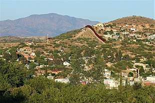
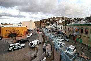
Nogales, Arizona borders the city of Nogales, Sonora, Mexico, and is Arizona's largest international border community. The southern terminus of Interstate 19 is located in Nogales at the U.S.-Mexico border; the highway continues south into Mexico as Mexico Federal Highway 15. The highways meeting in Nogales are a major road intersection in the CANAMEX Corridor, connecting Canada, the United States, and Mexico. Nogales also is the beginning of the Arizona Sun Corridor, an economically important trade region stretching from Nogales to Prescott, including the Tucson and Phoenix metropolitan areas.
Nogales is home to four international ports of entry, including the Morley Pedestrian Port of Entry, Dennis Deconcini Pedestrian and Passenger Vehicle Port of Entry, Nogales International Airport, and the Mariposa Port of Entry. The Nogales-Mariposa Port of Entry has twelve passenger vehicle inspection lanes and eight commercial inspection lanes.
Due to its location on the border and its major ports of entry, Nogales funnels an estimated $30 billion worth of international trade into Arizona and the United States, per year, in fresh produce and manufactured goods from Mexico and the world through the deep sea port in Guaymas, Sonora, Mexico. This trade helps to support tens of thousands of jobs and the overall economies in Ambos Nogales and throughout the American state of Arizona and the Mexican state of Sonora.[7]
The name Nogales means "walnut trees" in Spanish, and the black walnut trees which once grew abundantly in the mountain pass between the cities of Nogales, Arizona, and Nogales, Sonora, can still be found around the town.
History
The name "Nogales" is derived from the Spanish word for "walnut" or "walnut tree." It refers to the large stands of walnut trees that once stood in the mountain pass where Nogales is located.[8]
Nogales was at the beginning of the 1775–1776 Juan Bautista de Anza Expedition as it entered the present day U.S. from New Spain, and the town is now on the Juan Bautista de Anza National Historic Trail. On the second floor of the 1904 Nogales Courthouse is a small room dedicated to the 1775–1776 Anza Expedition.[9]
In 1841, a land grant from the Mexican government to the Elías family established Los Nogales de Elías. Following the Gadsden purchase in 1853, Nogales became a part of the United States of America. In 1880, Russian immigrant Jacob Isaacson built a trading post at present-day Nogales. The U.S. Postal Service opened the Isaacson post office but renamed it as Nogales in 1883.[10]
In 1915, according to historian David Leighton, Sonora Gov. Jose M. Maytorena ordered construction of an 11-wire fence, separating Nogales, Sonora from Nogales, Arizona, but it was taken down four months later.[11]
On August 27, 1918, a battle between United States Army forces and Mexican militia - mostly civilian in composition - took place. Culminating as the result of a decade's worth of tensions originating from the Mexican Revolution and earlier battles in Nogales along the border in 1913 and 1915, the main consequence of the 1918 violence saw the building of the first permanent border wall between Nogales, Arizona, and Nogales, Sonora, along the previously unobstructed boundary line on International Street.
Geography
According to the United States Census Bureau, the city has a total area of 20.8 square miles (54 km2), all of it land.
The city is at an elevation of 3,829 feet (1,167 m).[1]
Climate
Nogales has a semi-arid steppe climate, which is less hot and more rainy than a typical arid climate classification such as Phoenix. In the winter months, Nogales averages in the mid to upper 60s, with January averaging daily highs of around 63 °F or 17.2 °C. Lows typically settle just below the freezing mark (32 °F or 0 °C) on a majority of nights, but it is not uncommon to see temperatures tumble below 25 °F or −3.9 °C on some winter nights.
On the other hand, in the summer months, highs average between 90 and 100 °F (32.2 and 37.8 °C), with the month of June being the hottest with an average daytime high of 96 °F or 35.6 °C. Nighttime lows for the summer months remain in the upper 50s and lower 60s for the duration of the season. The Arizona Monsoon generally runs through July and August, and these months typically see eight inches or more of combined rainfall, which brings the average annual precipitation for Nogales to about 16 inches or 410 millimetres. Some monsoon season storms are capable of producing several inches of rain in a short amount of time, creating flash flood hazards.
Nogales’ all-time highest recorded temperature is 112 °F or 44.4 °C, which was reached on June 26, 1990. The lowest recorded temperature was −4 °F or −20 °C on December 8, 1978.
| Climate data for Nogales, Arizona | |||||||||||||
|---|---|---|---|---|---|---|---|---|---|---|---|---|---|
| Month | Jan | Feb | Mar | Apr | May | Jun | Jul | Aug | Sep | Oct | Nov | Dec | Year |
| Record high °F (°C) | 88 (31) |
89 (32) |
95 (35) |
100 (38) |
107 (42) |
112 (44) |
109 (43) |
108 (42) |
105 (41) |
101 (38) |
93 (34) |
84 (29) |
112 (44) |
| Average high °F (°C) | 63.3 (17.4) |
66.7 (19.3) |
70.8 (21.6) |
78.0 (25.6) |
85.5 (29.7) |
94.6 (34.8) |
93.7 (34.3) |
91.1 (32.8) |
89.5 (31.9) |
82.1 (27.8) |
72.4 (22.4) |
64.7 (18.2) |
79.3 (26.3) |
| Average low °F (°C) | 28.8 (−1.8) |
30.9 (−0.6) |
34.7 (1.5) |
40.0 (4.4) |
46.4 (8.0) |
56.3 (13.5) |
64.6 (18.1) |
62.3 (16.8) |
56.3 (13.5) |
44.8 (7.1) |
34.3 (1.3) |
29.6 (−1.3) |
44.1 (6.7) |
| Record low °F (°C) | 6 (−14) |
9 (−13) |
13 (−11) |
7 (−14) |
24 (−4) |
34 (1) |
44 (7) |
40 (4) |
30 (−1) |
19 (−7) |
8 (−13) |
−4 (−20) |
−4 (−20) |
| Average precipitation inches (mm) | 1.02 (26) |
0.86 (22) |
0.84 (21) |
0.28 (7.1) |
0.16 (4.1) |
0.42 (11) |
4.14 (105) |
3.85 (98) |
1.63 (41) |
0.89 (23) |
0.73 (19) |
1.18 (30) |
16 (407.2) |
| Average snowfall inches (cm) | 0.6 (1.5) |
0.6 (1.5) |
0.6 (1.5) |
0.2 (0.51) |
0.0 (0.0) |
0.0 (0.0) |
0.0 (0.0) |
0.0 (0.0) |
0.0 (0.0) |
0.1 (0.25) |
0.2 (0.51) |
0.8 (2.0) |
3.1 (7.9) |
| Source 1: [12] | |||||||||||||
| Source 2: [13] (for extremes) | |||||||||||||
Demographics
| Historical population | |||
|---|---|---|---|
| Census | Pop. | %± | |
| 1890 | 1,194 | — | |
| 1900 | 1,761 | 47.5% | |
| 1910 | 3,514 | 99.5% | |
| 1920 | 5,199 | 48.0% | |
| 1930 | 6,006 | 15.5% | |
| 1940 | 5,135 | −14.5% | |
| 1950 | 6,153 | 19.8% | |
| 1960 | 7,286 | 18.4% | |
| 1970 | 8,946 | 22.8% | |
| 1980 | 15,683 | 75.3% | |
| 1990 | 19,489 | 24.3% | |
| 2000 | 20,878 | 7.1% | |
| 2010 | 20,837 | −0.2% | |
| Est. 2019 | 20,103 | [5] | −3.5% |
| U.S. Decennial Census[14] | |||
As of the census[15] of 2010, there were 20,878 people, 5,985 households, and 4,937 families residing in the city. The population density was 1,002.1 people per square mile (387.0/km2). There were 6,501 housing units at an average density of 312.0 per square mile (120.5/km2). The racial makeup of the city was 71.7% White, 0.37% Black or African American, 0.57% Native American, 0.6% Asian, 0.0% Pacific Islander, 24.3% from other races, and 2.4% from two or more races. 95% of the population were Hispanic or Latino of any race.
There were 6,362 households, out of which 38.8% had children under the age of 18 living with them, 47.9% were married couples living together, 24.2% had a female householder with no husband present, and 22.5% were non-families. 15.1% of all households were made up of individuals, and 9.9% had someone living alone who was 65 years of age or older. The average household size was 3.12 and the average family size was 3.62.
In the city, the population was spread out, with 34.6% under the age of 18, 9.5% from 18 to 24, 25.5% from 25 to 44, 19.5% from 45 to 64, and 10.8% who were 65 years of age or older. The median age was 30 years. For every 100 females, there were 88.1 males. For every 100 females age 18 and over, there were 81.3 males.
The median income for a household in the city was $28,044, and the median income for a family was $24,637. Males had a median income of $24,636 versus $18,403 for females. The per capita income for the city was $14,440. About 30.8% of families and 32.7% of the population were below the poverty line, including 41.2% of those under age 18 and 32.9% of those age 65 or over.
Economy
The economy of Nogales is heavily dependent on the cross-border trade through its Ports of Entry by produce distributors and American-based manufacturing plants in Nogales, Sonora and throughout the rest of the Mexican states of Sonora and Sinaloa. Most of Nogales' economy is based on agribusiness and produce distributors, which comes from large farms in the Mexican agri-belt. Despite its small population, Nogales actually receives much patronage from its bordering sister-city, Nogales, Sonora, Mexico. Most observers guess the population of Nogales, Sonora, at roughly 300,000. International commerce is a big part of Nogales’ economy.[16] More than 60 percent of Nogales’ sales tax comes from the estimated 30,000 Mexican shoppers crossing the border daily.[17] Nogales, Arizona, and Nogales, Sonora, are home to one of the largest maquiladora clusters. This enables American manufacturing plants on both sides of the border to take advantage of favorable wage and operating costs and excellent transportation and distribution networks.
The Consulate-General of Mexico in Nogales is located on 135 W. Cardwell St.[18]
The United States Department of Homeland Security is a major economic driver in the Ambos Nogales region, with thousands of employees working for both the Border Patrol and Customs and Border Protection. Due to the large federal, state, and local police presence, Nogales has one of the highest police per-capita levels in the United States.
The largest employers in Nogales are:[19]
- Seattle Sports
- City of Nogales
- County of Santa Cruz
- Dependable Home Health
- E.D.S. Manufacturing
- Holy Cross Hospital
- The Home Depot
- Mariposa Community Health Center
- Nogales Unified School District
- Safeway
- Prestolite Wire
- UPS Supply Chain Solutions
- Walmart
Community facilities
The city of Nogales has a wide range of community facilities. These include nine parks, the Pimería Alta Historical Society Museum, an art gallery, Oasis Movie Theater, four recreation centers, four swimming pools, eight athletic fields, a library, six tennis courts and three golf courses. It has public elementary schools, middle schools, and high schools. Its financial institutions include six banks. Its governmental agencies include a staffed city and local fire department and a city police department. It is home to Nogales International Airport, which includes a 7,200 ft. runway and a terminal with a customs facility, passenger waiting areas, and a coffee shop. It has two regional health care facilities, including Carondolet Holy Cross Hospital located at 1171 W Target Range Road, and Mariposa Health Clinic located at 1852 N Mastick Way.
Area golf courses include:
- Kino Springs Golf Course
- Tubac Golf Resort and Spa
The Nogales area is served by the Nogales Unified School District for K-12 education, including 5 elementary schools, two middle schools, Nogales High School, and Pierson Vocational High School. Institutions of higher learning include Cochise College, University of Arizona Santa Cruz, and University of Phoenix.
City Hall is located at 777 North Grand Avenue. The Police Department and Fire Department are both housed here, with Fire Station 2 located at 2751 N Grand Avenue. The City Recreation Center is located at 1500 N Hohokam Drive and has a basketball court and year-round swimming pool. Softball and a soccer field are found adjacent to the Recreation Center. Public Works is located at 1450 N Hohokam Drive. A waste transfer facility is located there for public use. A skate park, baseball stadium, and little league baseball field are located at 100 E Madison St.
Santa Cruz County administrative offices, courts, and jail are located at 2150 N Congress Drive in Nogales.
Scenic attractions
The county of Santa Cruz and the city of Nogales have 200 properties listed in the National Register of Historic Sites, including Tumacacori National Monument first visited by Father Eusebio Kino in 1691 and Tubac Presidio, established by the Spanish in 1752 on an Indian village site. Others include the Old Tubac Schoolhouse, Old Nogales City Hall, Santa Cruz County Courthouse, and Patagonia Railroad Depot. The Patagonia-Sonoita Creek Sanctuary, 19 miles east, attracts worldwide visitors to see its diverse bird life. It is also host to ghost towns and mining camps, curio shops, first-class restaurants and night clubs.
The Santa Cruz County Historical Courthouse on Morley Street/Court Street has the statue of Lady Justice on top of the building. The Nogales version of Lady Justice is not wearing a blindfold.
The architecturally rich downtown area of Nogales near the Mexican–American border offers a unique opportunity for visitors to experience the downtown border-style shopping setting similar to those from the mid-20th century. Interesting architecture and historical homes along Crawford and Court Streets provide a glimpse of border life at its peak during that time period.[20] A day trip to old Nogales, Sonora reveals many of the same architectural uniqueness.
Several state parks and recreation areas are located close to Nogales, including Patagonia State Park, Peña Blanca Lake, Parker Canyon Lake, and Coronado National Forest. The Wine Country of Sonoita-Elgin is also located 20 miles east of Nogales.
Government
The City of Nogales operates under a council-manager form of government in which the mayor is elected to a 4-year term and has a single vote on the city council. The council then hires a city manager to run the day-to-day operations of the city. The 6 city council members are elected at-large to 4-year terms.[21]
- Mayor: Arturo R. Garino
- Mayor Arturo Garino was elected in November 2018, and took office in January 2019.
- City council:
- Vice-Mayor Jorge Maldonado
- Jose "Joe" Diaz
- Greg Lucero
- Nubar Hanessian
- Marcelino Varona
- Robert Rojas
- Acting City manager: Frank Felix
- Deputy city manager: John Kissinger
- City attorney: Joe Machado
- City clerk/city treasurer: Leticia Robinson
- City magistrate: Mayra Galindo
- Police chief: Roy Bermudez
Transportation
Nogales is located at the south end of Interstate 19. Arizona State Route 189 connects Interstate 19 with the Nogales-Mariposa Port of Entry and Mexican Federal Highway 15. Arizona State Route 82 connects Nogales with Patagonia and Sonoita. Interstate 11 is proposed to replace I-19, terminating in Nogales.
Santa Cruz County operates the Nogales International Airport, a general use airport.
Nogales does not currently have any public transportation.[22] Private bus companies Greyhound and TUFESA, as well as several shuttle companies, connect Nogales with Tucson and points north.[23][24][25]
In popular culture
Nogales, Arizona, was the filming location for the motion picture musical, Oklahoma!. Nogales was chosen because it looked more like turn-of-the-century Oklahoma (when the musical is set) than anywhere in Oklahoma did in 1955, when the film was made. It was made an "honorary" part of the state of Oklahoma for the duration of the film shoot by order of the governor of Arizona.
Many dozens of motion pictures have been filmed around the Nogales area.[26][27]
The 1951 biblical motion picture David and Bathsheba was filmed there.
A small part of William Gibson's short story, "The Gernsback Continuum" refers to the city of Nogales. It is also mentioned as a border crossing point in Carlos Castaneda's Don Juan series, and a gateway into the Mexican Yaqui communities of Sonora.
Nogales is a locale for filming some of the TV reality documentary, Border Wars, in particular in the second episode of that show's first season. The Animal Planet reality show Law on the Border was filmed in Nogales, highlighting the K-9 units of the Nogales Police Department.
The Hangover Part III was partially filmed in Nogales during late 2012. Parts of town were decorated to appear to be Tijuana, Mexico.[28]
Nogales is discussed at length in the popular political economics book Why Nations Fail, comparing the relative success of Nogales, AZ to the poverty of Nogales, Mexico.[29]
Oscar winner Benicio Del Toro dedicated his award to Ambos Nogales during his acceptance speech at the 73rd Annual Academy Awards in 2001.[30]
Sister cities
Notable people
- Bob Baffert - 2015 & 2018 Triple Crown winner, champion horse breeder and trainer, b. January 13, 1953.
- Andrew Leo Bettwy - Arizona State Land Commissioner 1970–78, b. May 31, 1920, d. January 12, 2004.
- Movita Castaneda - Actress best known for being the second wife of actor Marlon Brando. b. December 4, 1916 d.2/12/2015
- Travis Edmonson - Member of 1960's influential folk duo "Bud & Travis."
- John Frederick "Jack" Hannah - Academy Award-winning Disney Studios artist and director. b.1/15/1913 d.6/11/1994
- Gil Heredia - 10-year Major League Baseball pitcher and University of Arizona Sports Hall of Fame member, born 1965.
- Christine McIntyre - Actress, starred in 22 feature films, most notably as supporting character in Three Stooges films.
- Sergio Mendoza - Internationally acclaimed bandleader. Active. "Sergio Mendoza y La Orkesta", a.k.a. "Orkesta Mendoza", perform a Latin fusion style described as "Indie Mambo." b.5/23/1981.
- Charles Mingus - Jazz bass player, composer, and bandleader, b. April 22, 1922 in Nogales, d. May 1, 1979.
- Jack O'Connor - Longtime firearms editor for "Outdoor Life" magazine, hunted and collected trophies throughout the world, introduced readers to hunting and firearms, b. January 22, 1902, d. January 20, 1978.
- Alberto Alvaro Ríos - Author, poet, won the 1981 Walt Whitman award for "Whispering to Fool the Wind", current State of Arizona Poet Laureate.
- Roger Smith - Actor, star of 77 Sunset Strip, husband to movie star Ann-Margret.
- Verita Bouvaire-Thompson - Actress turned hairdresser best known for her 14-year reputed affair with actor Humphrey Bogart (b.1918, d. 2011)
References
- "Nogales". Geographic Names Information System. United States Geological Survey.
- Delaware.Net. "City of Nogales maintains "AA" rating from S&P". www.nogalesaz.gov. Archived from the original on August 8, 2017. Retrieved April 12, 2016.
- "2018 U.S. Gazetteer Files". United States Census Bureau. Retrieved July 1, 2019.
- "U.S. Census website". United States Census Bureau. Retrieved August 5, 2014.
- "Population and Housing Unit Estimates". Retrieved May 21, 2020.
- "Find a County". National Association of Counties. Archived from the original on May 31, 2011. Retrieved June 7, 2011.
- "$26 Billion in Cross-Border Trade". Biztucson.com. June 13, 2012. Archived from the original on July 30, 2012. Retrieved August 30, 2012.
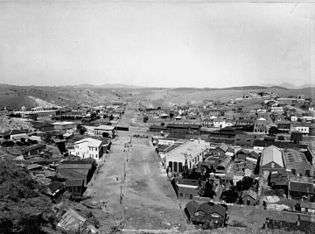
- "Welcome to Nogales, AZ". City of Nogales. Retrieved February 1, 2009.A view of the center of town from hillside, looking west along International Street, c. 1898–99
- "Anza Related Sites - Juan Bautista de Anza National Historic Trail (U.S. National Park Service)". Nps.gov. February 9, 2014. Retrieved March 1, 2014.
- "Nogales History". Pimeria Alta Museum. Retrieved February 1, 2009.
- Star, David Leighton For the Arizona Daily. "Street Smarts: First fence built to hold back cattle".
- "NOGALES, ARIZONA (025921)". Western Regional Climate Center. Retrieved August 28, 2016.
- "NOGALES 6 N, ARIZONA (025924)". Western Regional Climate Center. Retrieved April 8, 2018.
- "Census of Population and Housing". Census.gov. Retrieved June 4, 2016.
- "U.S. Census website". United States Census Bureau. Retrieved January 31, 2008.
- "Kyl, McCain to DHS: Speed up Nogales border crossings". Nogales International. Retrieved August 14, 2010.
- "Sales tax hike met with mixed response". Nogales International. Retrieved August 14, 2010.
- "Información sobre el consulado" (in Spanish). Consulate-General of Mexico in Nogales. Retrieved May 13, 2011.
- "Leadership that puts business first". AzCommerce.com. Retrieved August 30, 2012.
- "A day in Nogales Sonora". Thenogaleschamber.com. Archived from the original on August 20, 2012. Retrieved August 30, 2012.
- "City Government, City Council". Nogalesaz.gov. Archived from the original on October 5, 2012. Retrieved August 30, 2012.
- "Southeastern Arizona Regional TRANSPORTATION COORDINATION PLAN UPDATE 2016-2017" (PDF).
- Star, Arizona Daily. "Greyhound expands rural bus service in Southern Arizona". Arizona Daily Star. Retrieved December 29, 2016.
- Cronen, Julian; News, Karen Lizarraga/Arizona Sonora. "A shuttle service: 'Who's going to Nogales?'". Retrieved December 29, 2016.
- Curt Prendergast. "Stiff competition at shuttle central". Nogales International. Retrieved December 29, 2016.
- https://www.nogalesaz.gov/Film-Locations/
- https://www.imdb.com/search/title?locations=Nogales,%20Arizona,%20USA&page=1&ref_=adv_prv
- Prendergast, Curt (October 9, 2012). "Hollywood comes to Nogales" – via Nogales International.
- Acemoglu, Daron; Robinson, James A. (2017). Why Nations Fail: The Origins of Power, Prosperity, and Poverty. Currency. ISBN 978-0307719225.
- https://www.nogalesinternational.com/oscar-winner-del-toro-salutes-ambos-nogales/article_ed47b8ce-87d4-5b67-ae91-798bf0947358.html
External links
- Everything you want to know about Nogales - Bilingual
- Official government website
- Nogales-Santa Cruz County Chamber of Commerce
- Nogales Unified School District
- Nogales International Newspaper
- Border Eco Magazine
- official U.S. National Park Service Juan Bautista de Anza National Historic Trail website - Anza Trailhead Room at the 1904 Nogales Courthouse.
- Photo gallery of past mayors of Nogales, Arizona
- Nogales Community Profile
- David Leighton, "Street Smarts: First fence built to hold back cattle," Arizona Daily Star, April 6, 2015
Municipalities and communities of Santa Cruz County, Arizona, United States | ||
|---|---|---|
| City | 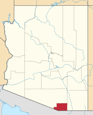 | |
| Town | ||
| CDPs | ||
| Populated places | ||
| Ghost towns | ||
| Authority control |
|
|---|