Sangam Jagarlamudi
SEKURU is a village in Guntur district of the Indian state of Andhra Pradesh. It is located in Tenali mandal of Tenali revenue division.[2] It forms a part of Andhra Pradesh Capital Region.[4]
Sangam Jagarlamudi | |
|---|---|
Village | |
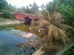 Kommamuru canal at Sangam Jagarlamudi in Guntur district | |
.svg.png) Sangam Jagarlamudi Location in Andhra Pradesh, India | |
| Coordinates: 16.2396°N 80.5855°E | |
| Country | India |
| State | Andhra Pradesh |
| District | Guntur |
| Mandal | Tenali |
| Seat | SEKURU Gram Panchayat |
| Government | |
| • Type | Panchayati raj |
| • Body | SEKURU Gram Sabha |
| Area | |
| • Total | 1,518 ha (3,751 acres) |
| Population (2011)[3] | |
| • Total | 9,246 |
| • Density | 610/km2 (1,600/sq mi) |
| Languages | |
| • Official | Telugu |
| Time zone | UTC+5:30 (IST) |
| PIN | 522212 |
| Area code(s) | +91–8644 |
| Vehicle registration | AP |
Geography
SEKURU is situated to the west Tenali,[5] at 16.2396°N 80.5855°E. The village is spread over an area of 3.70 km2 (1.43 sq mi).[2] The Buckingham Canal and the Tungabhadra drain confluence near the village.[5]:116 The summer storage tank at the village supplies water to Guntur Municipal Corporation.[6]
Demographics
As of 2011 census, SEKURU had a population of 5,447. The total population constitute, 2,679 males and 2,768 females —a sex ratio of 1033 females per 1000 males. 482 children are in the age group of 0–6 years, of which 243 are boys and 239 are girls. The average literacy rate stands at 62.62% with 3,709 literates, significantly higher than the state average of 67.41%.[3][7]
Government and politics
SEKURUgram panchayat is the local self-government of the village.[1] There are 14 wards, each represented by an elected ward member.[8] The present sarpanch is vacant, elected indirectly by the ward members.[9] The village is administered by the Tenali Mandal Parishad at the intermediate level of panchayat raj institutions.[5]
Culture
SEKURU temple of Lord Shiva is a Hindu pilgrimage site and draws many pilgrims during the festival of Maha Shivaratri.[10]
Transport
Tenali–Narakodur road passes through Sangam Jagarlamudi.[11] Rural road connects the village with Selapadu.[12] On this route, APSRTC operates buses from Guntur and Tenali bus stations. Sangam Jagarlamudi railway station provides rail connectivity and is situated on Guntur–Tenali section of Guntur railway division.[13]
Education
As per the school information report for the academic year 2018–19, the village has a total of 7 schools. These include one private and 6 Zilla/Mandal Parishad schools.[14] SEKURU Zilla Parishad High School is a district council funded school, which provides secondary education in the village.[15]
See also
References
- "Gram Panchayat Identification Codes" (PDF). Saakshar Bharat Mission. National Informatics Centre. p. 121. Archived from the original (PDF) on 18 August 2017. Retrieved 7 May 2019.
- "District Census Hand Book – Guntur" (PDF). Census of India. Registrar General and Census Commissioner of India. pp. 14, 414. Retrieved 9 May 2019.
- "Population". Census of India. Registrar General and Census Commissioner of India. Retrieved 9 May 2019.
- "Declaration of A.P. Capital Region" (PDF). Andhra Pradesh Capital Region Development Authority. Municipal Administration and Urban Development Department, Andhra Pradesh. 30 December 2014. p. 4. Archived (PDF) from the original on 11 May 2019. Retrieved 17 May 2019.
- "District Census Hand Book – Guntur (Village and Town Directory)" (PDF). Census of India. Registrar General and Census Commissioner of India. pp. 650–651. Retrieved 31 May 2019.
- "No Water Supply on January 11, 12 in Guntur". The New Indian Express. Retrieved 4 May 2016.
- "Literacy of AP (Census 2011)" (PDF). Official Portal of Andhra Pradesh Government. p. 43. Retrieved 5 September 2014.
- "Local Body Elected Members of Sangam Jagarlamudi". Area Profiler. Ministry of Panchayati Raj. Retrieved 31 May 2019.
- Mathew, George; Sciences, Institute of Social (1995). Status of Panchayati Raj in the States of India, 1994. Concept Publishing Company. pp. 19, 78. ISBN 9788170225539. Retrieved 31 May 2019.
- "Maha Sivaratri celebrated with religious fervour". The Hindu. 21 February 2012. ISSN 0971-751X. Retrieved 8 May 2016.
- "Existing State Highways" (PDF). Andhra Pradesh Road Development Corporation. Government of Andhra Pradesh. p. 10. Archived from the original (PDF) on 20 September 2018. Retrieved 10 May 2019.
- "Computerization of PR-Engineering Dept". predmis.ap.nic.in. Panchayati Raj Engineering Department, Andhra Pradesh. 10 May 2019. Retrieved 10 May 2019.
- "Distances in kilometers between stations on the Tenali Jn. - Repalle section" (PDF). Indian Railways. 12 September 2009. p. 61. Retrieved 30 April 2019.
- "School Information". Commissionerate of School Education. Government of Andhra Pradesh. Retrieved 7 May 2019.
- "List of High Schools" (PDF). Sakshi Education. Retrieved 5 May 2016.
Template:Villages in CHEBROLU mandal
External links
| Wikimedia Commons has media related to Sangam Jagarlamudi. |