Thandwe
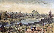
Thandwe ("Thandway" in Arakanese; Burmese: သံတွဲမြို့; MLCTS: samtwai: mrui. [θàɰ̃dwɛ́ mjo̰]; formerly Sandoway) is a town and major seaport in Rakhine State, the westernmost part of Myanmar. Thandwe is very ancient, and is said to have been at one time the capital of Rakhine State, then called Arakan. The district has an area of 3,784 square miles (9,800 km2). The area is mountainous, and spurs of the Arakan Mountains reach the coast. Some of the peaks in the north are over 4,000 feet (1,200 m) high. The streams are only mountain torrents to within a few miles of the coast; the mouth of the Khwa forms a good anchorage for small boats. The rocks in the Arakan Range and its spurs are metamorphic, and include clay, slates, ironstone and indurated sandstone; towards the south, ironstone, trap and rocks of basaltic character are common; veins of steatite and white fibrous quartz are also found. Between 1961 and 1990, the mean annual rainfall was 5,323 millimetres (209.6 in). Except for a few acres of tobacco, all of the cultivation is rice.
Thandwe သံတွဲမြို့ | |
|---|---|
Town | |
| Thandwe | |
 Thandwe | |
| Coordinates: 18°27′54.41″N 94°21′59.54″E | |
| Country | |
| State | |
| Township | Thandwe |
| Town | Thandwe |
| Area | |
| • Town | 3,522.798 km2 (1,360.160 sq mi) |
| Population (2014) | |
| • Town | 133,484[1] |
| • Urban | 14,327 |
| Time zone | UTC6:30 (MST) |
| Postal code | 0717x |
| Calling code | 4365 |
Climate
Thandwe has a tropical monsoon climate (Köppen climate classification Am). Temperatures are very warm throughout the year. There is a winter dry season (November–April) and a summer wet season (May–October). Torrential rain falls from June to September, with over 1,200 millimetres (47 in) falling in each of the months of June, July and August. The rainfall in 1905 was 230.49 inches (5,854 mm).
| Climate data for Thandwe (1981–2010, extremes 1978–1994) | |||||||||||||
|---|---|---|---|---|---|---|---|---|---|---|---|---|---|
| Month | Jan | Feb | Mar | Apr | May | Jun | Jul | Aug | Sep | Oct | Nov | Dec | Year |
| Record high °C (°F) | 37.2 (99.0) |
35.0 (95.0) |
37.8 (100.0) |
37.2 (99.0) |
37.8 (100.0) |
37.2 (99.0) |
32.8 (91.0) |
32.8 (91.0) |
35.0 (95.0) |
33.9 (93.0) |
36.1 (97.0) |
32.8 (91.0) |
37.8 (100.0) |
| Average high °C (°F) | 31.0 (87.8) |
32.4 (90.3) |
33.6 (92.5) |
34.9 (94.8) |
33.7 (92.7) |
30.3 (86.5) |
29.7 (85.5) |
29.6 (85.3) |
31.3 (88.3) |
33.2 (91.8) |
32.6 (90.7) |
31.4 (88.5) |
32.0 (89.6) |
| Average low °C (°F) | 12.1 (53.8) |
13.4 (56.1) |
17.9 (64.2) |
22.5 (72.5) |
24.3 (75.7) |
23.7 (74.7) |
23.4 (74.1) |
23.4 (74.1) |
23.3 (73.9) |
22.9 (73.2) |
19.9 (67.8) |
15.2 (59.4) |
20.2 (68.4) |
| Record low °C (°F) | 7.2 (45.0) |
7.2 (45.0) |
10.0 (50.0) |
16.1 (61.0) |
20.0 (68.0) |
20.0 (68.0) |
17.8 (64.0) |
20.0 (68.0) |
20.0 (68.0) |
18.9 (66.0) |
12.2 (54.0) |
8.3 (46.9) |
7.2 (45.0) |
| Average rainfall mm (inches) | 2.6 (0.10) |
6.7 (0.26) |
4.3 (0.17) |
16.6 (0.65) |
341.7 (13.45) |
1,277.6 (50.30) |
1,390.2 (54.73) |
1,374.7 (54.12) |
675.5 (26.59) |
204.6 (8.06) |
74.0 (2.91) |
11.2 (0.44) |
5,379.7 (211.80) |
| Source 1: Norwegian Meteorological Institute[2] | |||||||||||||
| Source 2: Sistema de Clasificación Bioclimática Mundial (records)[3] | |||||||||||||
References
- "Population of Myanmar". Ministry of Immigration and Population (Myanmar) (in Burmese). 2014-03-29. Retrieved 9 April 2016.
- "Myanmar Climate Report" (PDF). Norwegian Meteorological Institute. pp. 23–36. Archived from the original (PDF) on 8 October 2018. Retrieved 30 November 2018.
- "Sandoway (Myanmar)" (PDF). Centro de Investigaciones Fitosociológicas. Retrieved 13 December 2018.

External links
| Wikivoyage has a travel guide for Thandwe. |
Capital: Sittwe | ||
| Kyaukpyu District |  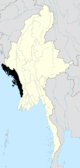 | |
| Maungdaw District | ||
| Sittwe District | ||
| Thandwe District |
| |
| Mrauk-U District | ||
| Main cities and towns | ||