San Juanico Strait
San Juanico Strait (Filipino: Kipot ng San Juanico) is a narrow strait in the Eastern Visayan region in the Philippines.[1] It separates the islands of Samar and Leyte and connects the Carigara Bay (Samar Sea) with the San Pedro Bay (Leyte Gulf). It is about 38 kilometres (24 mi) long. At its narrowest point, the strait is only 2 kilometers (1.2 mi) wide.[2]
| San Juanico Strait | |
|---|---|
 Aerial view of the San Juanico Bridge over the strait | |
.svg.png) San Juanico Strait Location within the Philippines .svg.png) San Juanico Strait San Juanico Strait (Philippines) | |
| Location |
|
| Coordinates | 11°20′25″N 124°58′42″E |
| Type | strait |
The strait is crossed by the San Juanico Bridge. The HVDC Leyte–Luzon power line also crosses the strait through an overhead line at 11°23′36″N 124°59′04″E, using a tower on an uninhabited island in the strait. The Tacloban City harbor, the main port of the Eastern Visayas, is on Cancabato Bay at the southern entrance of the strait.[3]
Gallery
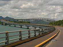 View of the San Juanico Bridge over the strait, looking southeastward.
 The San Juanico Bridge at night.
_(14792206793).jpg) 1900 map of the strait.
1900 map of the strait.
References
- "San Juanico Strait: Philippines". Geographical Names. Geographic.org. Retrieved 28 October 2013.
- "Endless Samar". Manila Bulletin. 2 February 2018. Retrieved 26 March 2018.
- "Port Management Office of Tacloban". Philippine Ports Authority. Archived from the original on 28 July 2016. Retrieved 26 March 2018.
External links

Seas of the Philippines | ||
|---|---|---|
| Ocean |  | |
| Sea | ||
| Strait |
| |
| Gulf | ||
See also: Bodies of water of the Philippines | ||
This article is issued from Wikipedia. The text is licensed under Creative Commons - Attribution - Sharealike. Additional terms may apply for the media files.