Salla
Salla (Kuolajärvi until 1936) is a municipality of Finland, located in Lapland. The municipality has a population of 3,485 (31 January 2019)[2] and covers an area of 5,873.08 square kilometres (2,267.61 sq mi) of which 142.73 km2 (55.11 sq mi) is water.[1] The population density is 0.61 inhabitants per square kilometre (1.6/sq mi). Neighbour municipalities are Kemijärvi, Kuusamo, Pelkosenniemi, Posio and Savukoski. The nearby settlement of Sallatunturi is home to the Salla Ski Resort.
Salla | |
|---|---|
Municipality | |
| Sallan kunta Salla kommun | |
 Salla church | |
 Coat of arms | |
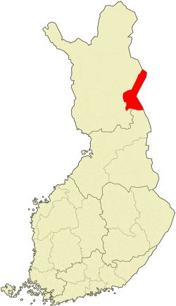 Location of Salla in Finland | |
| Coordinates: 66°50′N 028°40′E | |
| Country | |
| Region | Lapland |
| Sub-region | Eastern Lapland sub-region |
| Charter | 1857 |
| Government | |
| • Municipal manager | Kari Väyrynen |
| Area (2018-01-01)[1] | |
| • Total | 5,873.08 km2 (2,267.61 sq mi) |
| • Land | 5,729.48 km2 (2,212.16 sq mi) |
| • Water | 142.73 km2 (55.11 sq mi) |
| Area rank | 7th largest in Finland |
| Population (2019-01-31)[2] | |
| • Total | 3,485 |
| • Rank | 207th largest in Finland |
| • Density | 0.61/km2 (1.6/sq mi) |
| Population by native language | |
| • Finnish | 98.9% (official) |
| • Swedish | 0.1% |
| • Sami | 0.1% |
| • Others | 0.9% |
| Population by age | |
| • 0 to 14 | 11% |
| • 15 to 64 | 61.3% |
| • 65 or older | 27.7% |
| Time zone | UTC+02:00 (EET) |
| • Summer (DST) | UTC+03:00 (EEST) |
| Municipal tax rate[5] | 19.5% |
| Website | www.salla.fi |
History
Salla is in the Eastern Lapland and as a border area was affected by the Second World War. Red Army troops invaded Finland at Salla during the Winter War but were stopped by the Finnish Army (see Battle of Salla). Parts of the municipality were ceded to the Soviet Union after the war. The ceded part is sometimes called "Old Salla" or Vanha Salla. During the Continuation War the old town of Salla was on the Soviet side of the border. The German XXXVI Corps attacked the Soviet positions in an operation code-named Polarfuchs. With the help of the Finnish 6th Division it managed to occupy all of the ceded territories. At the end of the war the German troops were pushed out of Lapland by Finnish troops in the Lapland War.
The following villages were ceded to the Soviet Union: Alakurtti, Korja (Korya), Kuolajärvi (Kuoloyarvi), Lampela, Sallansuu, Yläkurtti (Yulyakurtti), Sovajärvi (Sovayarvi), Tuutijärvi (Tuutiyarvi) and Vuorijärvi (Vuoriyarvi).
Communications
Salla is the terminus of a freight-only railway line from Kemijärvi. In 2006, the Finnish Rail Administration announced proposals to close the line.[6] The line formerly extended beyond Salla into Russia.
Climate
| Climate data for Salla Kk (1981–2010) | |||||||||||||
|---|---|---|---|---|---|---|---|---|---|---|---|---|---|
| Month | Jan | Feb | Mar | Apr | May | Jun | Jul | Aug | Sep | Oct | Nov | Dec | Year |
| Record high °C (°F) | 5.5 (41.9) |
5.5 (41.9) |
9.7 (49.5) |
17.5 (63.5) |
26.4 (79.5) |
30.3 (86.5) |
31.5 (88.7) |
28.7 (83.7) |
20.9 (69.6) |
14.0 (57.2) |
8.2 (46.8) |
4.9 (40.8) |
31.5 (88.7) |
| Average high °C (°F) | −9.1 (15.6) |
−8.1 (17.4) |
−2.7 (27.1) |
3.4 (38.1) |
10.1 (50.2) |
16.3 (61.3) |
19.2 (66.6) |
15.9 (60.6) |
10.0 (50.0) |
2.8 (37.0) |
−3.5 (25.7) |
−7.2 (19.0) |
3.9 (39.0) |
| Daily mean °C (°F) | −13.1 (8.4) |
−12.2 (10.0) |
−7.2 (19.0) |
−1.1 (30.0) |
5.3 (41.5) |
11.4 (52.5) |
14.3 (57.7) |
11.3 (52.3) |
6.1 (43.0) |
0.2 (32.4) |
−6.5 (20.3) |
−11.0 (12.2) |
−0.2 (31.6) |
| Average low °C (°F) | −18.0 (−0.4) |
−17.4 (0.7) |
−12.6 (9.3) |
−6.3 (20.7) |
0.4 (32.7) |
6.0 (42.8) |
9.2 (48.6) |
6.7 (44.1) |
2.4 (36.3) |
−2.7 (27.1) |
−10.0 (14.0) |
−15.4 (4.3) |
−4.8 (23.4) |
| Record low °C (°F) | −45.3 (−49.5) |
−40.6 (−41.1) |
−36.5 (−33.7) |
−27.4 (−17.3) |
−16.5 (2.3) |
−4.3 (24.3) |
−1.5 (29.3) |
−5.5 (22.1) |
−12.6 (9.3) |
−26.2 (−15.2) |
−35.8 (−32.4) |
−40.2 (−40.4) |
−45.3 (−49.5) |
| Average precipitation mm (inches) | 35 (1.4) |
30 (1.2) |
32 (1.3) |
28 (1.1) |
46 (1.8) |
57 (2.2) |
77 (3.0) |
65 (2.6) |
50 (2.0) |
48 (1.9) |
39 (1.5) |
37 (1.5) |
544 (21.4) |
| Average precipitation days | 10 | 9 | 9 | 7 | 9 | 10 | 11 | 11 | 9 | 10 | 11 | 11 | 117 |
| Average relative humidity (%) | 86 | 85 | 81 | 72 | 69 | 67 | 73 | 80 | 85 | 88 | 90 | 87 | 80 |
| Source: Finnish Meteorological Institute[7] | |||||||||||||
Historical places
| Name | Place | Description | WGS 84 |
|---|---|---|---|
| The evangelic-Lutheran church of Salla | |||
| The Paikanselkä memorial area | Paikanselkä | The Winter War front line 13 March 1940, when war ended. Located where the commander of the Swedish voluntary troops, lieutenant colonel Magnus Dyrssen fell on 1 March 1940.[8] | |
| The Salpa Line |
Gallery
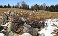 The Salpa Line anti-tank obstacles in Aholanvaara
 The Salpa Line anti-tank obstacles in Aholanvaara
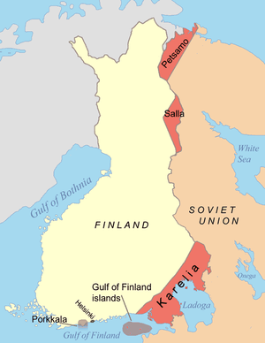 Areas ceded to Soviet Union at the end of World War II
References
- "Area of Finnish Municipalities 1.1.2018" (PDF). National Land Survey of Finland. Retrieved 30 January 2018.
- "Suomen virallinen tilasto (SVT): Väestön ennakkotilasto [verkkojulkaisu]. Tammikuu 2019" (in Finnish). Statistics Finland. Retrieved 15 March 2019.
- "Population according to language and the number of foreigners and land area km2 by area as of 31 December 2008". Statistics Finland's PX-Web databases. Statistics Finland. Retrieved 29 March 2009.
- "Population according to age and gender by area as of 31 December 2008". Statistics Finland's PX-Web databases. Statistics Finland. Retrieved 28 April 2009.
- "List of municipal and parish tax rates in 2011". Tax Administration of Finland. 29 November 2010. Retrieved 13 March 2011.
- Finnish Railway News – Year 2006
- "Climate data for Finland locations" (PDF). FMI. Retrieved 30 May 2016.
- http://loma.salla.fi/fi/eramaa/kayntikohteet-_nahtavyydet/sotamuistomerkit_ja_kohteet/
External links
![]()
- Municipality of Salla – Official website
| Municipalities |  | |
|---|---|---|
| Former municipalities | ||