Salisbury Parish, New Brunswick
Salisbury is a Canadian parish in Westmorland County, New Brunswick.[2]
Salisbury | |
|---|---|
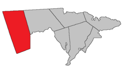 Location within Westmorland County, New Brunswick. | |
| Coordinates: 47.67°N 67.45°W | |
| Country | |
| Province | |
| County | Westmorland County |
| Established | 1787 |
| Area | |
| • Land | 874.16 km2 (337.52 sq mi) |
| Population (2016)[1] | |
| • Total | 3,388 |
| • Density | 3.9/km2 (10/sq mi) |
| • Change 2011-2016 | |
| • Dwellings | 1,430 |
| Time zone | UTC-4 (AST) |
| • Summer (DST) | UTC-3 (ADT) |
History
Salisbury Parish was established in 1787, and was named for John Salisbury (Salusbury) who accompanied Governor Edward Cornwallis to Nova Scotia or for the cathedral city of Salisbury in Wiltshire, England.
Delineation
Salisbury Parish is defined in the Territorial Division Act[3] as being bounded:
- North, west and south by the County lines; and east by Moncton Parish and the County of Albert.
Communities
Parish population total does not include incorporated municipalities (in bold):
|
|
|
Demographics
Population
|
LanguageMother tongue (2016)[1]
| ||||||||||||||||||||||||||||||||||||||||||
Access routes
Highways and numbered routes that run through the parish, including external routes that start or finish at the parish limits:[6]
See also
References
- "Census Profile, 2016 Census: Salisbury, Parish [Census subdivision], New Brunswick". Statistics Canada. Retrieved October 5, 2019.
- "Salisbury Parish". New Brunswick Provincial Archives.
- "Territorial Division Act (R.S.N.B. 1973, c. T-3)". Government of New Brunswick website. Retrieved 25 August 2016.
- Statistics Canada: 2001, 2006 census
- 2011 Statistics Canada Census Profile: Salisbury Parish, New Brunswick
- Atlantic Canada Back Road Atlas ISBN 978-1-55368-618-7
Places adjacent to Salisbury Parish, New Brunswick | |
|---|---|
| Subdivisions |
|
|---|---|
| Cities | |
| Counties | |
| |
This article is issued from Wikipedia. The text is licensed under Creative Commons - Attribution - Sharealike. Additional terms may apply for the media files.