Cardwell Parish, New Brunswick
Cardwell is a Canadian parish in Kings County, New Brunswick.[2]
Cardwell | |
|---|---|
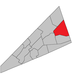 Location within Kings County, New Brunswick. | |
| Coordinates: 45.84°N 64.59°W | |
| Country | |
| Province | |
| County | Kings County |
| Established | 1874 |
| Area | |
| • Land | 311.90 km2 (120.43 sq mi) |
| Population (2016)[1] | |
| • Total | 1,353 |
| • Density | 4.3/km2 (11/sq mi) |
| • Change 2011-2016 | |
| • Dwellings | 709 |
| Time zone | UTC-4 (AST) |
| • Summer (DST) | UTC-3 (ADT) |
History
Cardwell Parish set off from Sussex Parish in 1874: named for Edward Cardwell (1813-1886), Secretary of State for the Colonies from 1864-1874.
Delineation
Cardwell Parish is defined in the Territorial Division Act[3] as being bounded:
- West by Sussex Parish and the east line of lot number twenty-five, granted to Jacob Snider, on the northern side of the Kennebecasis River, above Smith's Creek; north by a line running from the northeast angle of said lot north sixty-six degrees east to the County line; east by the County line, and south by a line commencing at the northwestern angle of lot number seven, granted to Simon Armstrong; thence east following the northern side line of the said grant and its prolongation easterly until it reaches the northeastern angle of lot number eighteen, granted to David Law; thence in a direct line to the northwestern angle of lot number eight, granted to Thomas Nicholson, in Lake block;[lower-alpha 1] thence along the northern line of said lot number eight and its eastern prolongation to the County line.
Governance
The entire parish forms the local service district of the parish of Cardwell, established in 1968 to assess for fire protection. Recreational and sports facilities was added to the assessment in 2012. First aid and ambulance services were listed from 1972 until the description was rewritten in 2012.
Communities
Parish population total does not include incorporated municipalities (in bold):
|
|
|
Bodies of water & Islands
This is a list of rivers, lakes, streams, creeks, marshes and Islands that are at least partially in this parish
- None
Demographics
Population
|
LanguageMother tongue (2016)[1]
|
Access Routes
Highways and numbered routes that run through the parish, including external routes that start or finish at the parish limits:[5]
See also
Footnotes
- Part of Mechanics Settlement.
References
- "Census Profile, 2016 Census: Cardwell, Parish [Census subdivision], New Brunswick". Statistics Canada. Retrieved September 11, 2017.
- New Brunswick Provincial Archives -Cardwell Parish
- "Territorial Division Act (R.S.N.B. 1973, c. T-3)". Government of New Brunswick website. Retrieved 18 August 2016.
- Statistics Canada: 2001, 2006 census
- Atlantic Canada Back Road Atlas ISBN 978-1-55368-618-7
Places adjacent to Cardwell Parish, New Brunswick | |
|---|---|
| Subdivisions |
|
|---|---|
| Cities | |
| Counties | |
| |