Saintigny
Saintigny is a commune in the Eure-et-Loir department in northern France. It was established on 1 January 2019 by merger of the former communes of Saint-Denis-d'Authou (the seat) and Frétigny.[1]
Saintigny | |
|---|---|
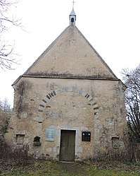 The chapel in Saint-Denis-d'Authou | |
Location of Saintigny 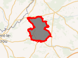
| |
 Saintigny  Saintigny | |
| Coordinates: 48°20′43″N 0°59′15″E | |
| Country | France |
| Region | Centre-Val de Loire |
| Department | Eure-et-Loir |
| Arrondissement | Nogent-le-Rotrou |
| Canton | Nogent-le-Rotrou |
| Intercommunality | Terres de Perche |
| Government | |
| • Mayor (2019–2020) | Luc Lamirault |
| Area 1 | 45.22 km2 (17.46 sq mi) |
| Population (2016) | 1,009 |
| • Density | 22/km2 (58/sq mi) |
| Time zone | UTC+01:00 (CET) |
| • Summer (DST) | UTC+02:00 (CEST) |
| INSEE/Postal code | 28331 /28480 |
| Elevation | 158–286 m (518–938 ft) |
| 1 French Land Register data, which excludes lakes, ponds, glaciers > 1 km2 (0.386 sq mi or 247 acres) and river estuaries. | |
References
- Arrêté préfectoral 19 December 2018 (in French)
| Wikimedia Commons has media related to Saintigny. |
This article is issued from Wikipedia. The text is licensed under Creative Commons - Attribution - Sharealike. Additional terms may apply for the media files.