Bonneval, Eure-et-Loir
Bonneval is a commune in the Eure-et-Loir department in northern France.
Bonneval | |
|---|---|
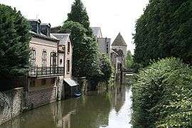 A general view of Bonneval | |
 Coat of arms | |
Location of Bonneval 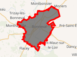
| |
 Bonneval  Bonneval | |
| Coordinates: 48°10′56″N 1°23′20″E | |
| Country | France |
| Region | Centre-Val de Loire |
| Department | Eure-et-Loir |
| Arrondissement | Châteaudun |
| Canton | Châteaudun |
| Intercommunality | Bonnevalais |
| Government | |
| • Mayor (2008–2014) | Joël Billard |
| Area 1 | 28.82 km2 (11.13 sq mi) |
| Population (2017-01-01)[1] | 5,055 |
| • Density | 180/km2 (450/sq mi) |
| Time zone | UTC+01:00 (CET) |
| • Summer (DST) | UTC+02:00 (CEST) |
| INSEE/Postal code | 28051 /28800 |
| Elevation | 112–175 m (367–574 ft) (avg. 132 m or 433 ft) |
| 1 French Land Register data, which excludes lakes, ponds, glaciers > 1 km2 (0.386 sq mi or 247 acres) and river estuaries. | |
Population
| Historical population | ||
|---|---|---|
| Year | Pop. | ±% |
| 1793 | 2,171 | — |
| 1800 | 1,551 | −28.6% |
| 1806 | 1,718 | +10.8% |
| 1821 | 1,779 | +3.6% |
| 1831 | 2,432 | +36.7% |
| 1836 | 2,560 | +5.3% |
| 1841 | 2,670 | +4.3% |
| 1846 | 2,869 | +7.5% |
| 1851 | 3,055 | +6.5% |
| 1856 | 3,004 | −1.7% |
| 1861 | 3,006 | +0.1% |
| 1866 | 3,486 | +16.0% |
| 1872 | 3,348 | −4.0% |
| 1876 | 3,398 | +1.5% |
| 1881 | 3,420 | +0.6% |
| 1886 | 3,631 | +6.2% |
| 1891 | 3,789 | +4.4% |
| 1896 | 3,818 | +0.8% |
| 1901 | 3,954 | +3.6% |
| 1906 | 4,011 | +1.4% |
| 1911 | 3,991 | −0.5% |
| 1921 | 3,597 | −9.9% |
| 1926 | 3,616 | +0.5% |
| 1931 | 3,627 | +0.3% |
| 1936 | 3,699 | +2.0% |
| 1946 | 3,803 | +2.8% |
| 1954 | 4,206 | +10.6% |
| 1962 | 4,628 | +10.0% |
| 1968 | 4,853 | +4.9% |
| 1975 | 4,892 | +0.8% |
| 1982 | 4,864 | −0.6% |
| 1990 | 4,420 | −9.1% |
| 1999 | 4,285 | −3.1% |
| 2008 | 4,432 | +3.4% |
References
- "Populations légales 2017". INSEE. Retrieved 6 January 2020.
| Wikimedia Commons has media related to Bonneval (Eure-et-Loir). |
| Authority control |
|
|---|
This article is issued from Wikipedia. The text is licensed under Creative Commons - Attribution - Sharealike. Additional terms may apply for the media files.