Saint Lawrence River Divide
The Saint Lawrence River Divide is a continental divide in central and eastern North America that separates the Great Lakes-St. Lawrence River Basin from the southerly Atlantic Ocean watersheds. Water, including rainfall and snowfall, lakes, rivers and streams, north and west of the divide, drains into the Gulf of St. Lawrence or the Labrador Sea; water south and east of the divide drains into the Atlantic Ocean (east of the Eastern Continental Divide, ECD) or Gulf of Mexico (west of the ECD). The divide is one of six continental divides in North America that demarcate several watersheds that flow to different gulfs, seas or oceans.
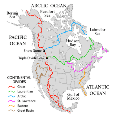
The divide has its origin at ‘Hill of Three Waters’ triple divide on the Laurentian Divide approx. 2 miles north of Hibbing, Minnesota. From there it swoops below the Great Lakes and into upper New York where it runs southeast of the St. Lawrence River dipping briefly below Lake Champlain before running northeasterly following the western border of Maine. It then turns southeasterly through central New Brunswick. From there, the divide runs easterly along the northern coast of Nova Scotia to Cape Canso.[1]
The hydrology of the Great Lakes-St. Lawrence basin is elaborate: Lake Nipigon drains via the Nipigon River, the primary tributary of Lake Superior, into Nipigon Bay in central northern Lake Superior. Lake Superior drains from its eastern end southeast via the St. Mary’s River into Lake Huron; hydrologically, Lake Michigan is one with Lake Huron through the wide Straits of Mackinac at the northern end; the southwestern portion of Lake Michigan drains via the Chicago Drainage Canal into the Illinois River thence to the Gulf of Mexico. Lake Huron drains through its southern tip southerly via the St. Clair River into Lake St. Clair then southerly via the Detroit River into western Lake Erie. Lake Erie drains northerly from its northeastern end via the Niagara River into the southwestern end of Lake Ontario. Lake Ontario drains northwesterly from its northwestern end into the St. Lawrence River, and thence into the Gulf of St. Lawrence. Finally, much of the coastal and central Labrador region, especially via Lake Melville, drains to the Labrador Sea.
Four canals cross the divide: The Champlain Canal connects Lake Champlain to the Hudson River watershed. The Erie Canal connects Lake Erie to the Hudson River watershed. The Chicago Sanitary and Ship Canal crosses the Chicago Portage and connects Lake Michigan to the Mississippi River watershed. The Portage Canal connects the Fox River to the Wisconsin River at Portage, Wisconsin. Historically there were additional canals, e.g., the Ohio and Erie Canal, but most of these are no longer in operation.
| Area | Point | Summit or other feature |
|---|---|---|
| Minnesota: The Hill of Three Waters[2] | 1,732 feet (528 m) 47.472366°N 92.964181°W |
Triple watershed point: watersheds of the Hudson Bay, Gulf of Mexico, & Gulf of Saint Lawrence. Nearest town: Hibbing, MN |
| Minnesota: Interstate 35 | 1,140 feet (350 m) 46.532422°N 92.630497°W |
Near Barnum, Minnesota |
| Ohio: Interstate 75 | 1,023 feet (312 m) 40.48426°N 84.16952°W |
I-75 passes over the Saint Lawrence River Divide between Pusheta Creek (Great Lakes Basin) and Loramie Creek (Mississippi basin) near mile marker 105 (kilometer 165).[3] |
| Pennsylvania: Interstate 86 | 1,488 feet (454 m) 42.138779°N 79.823920°W |
Crossing 1 of 5 |
| New York: Interstate 86 | 1,650 feet (500 m) 42.143894°N 79.672828°W |
Crossing 2 of 5 |
| New York: Interstate 86 | 1,579 feet (481 m) 42.147870°N 79.653323°W |
Crossing 3 of 5 |
| New York: New York State Route 16 | 1,680 feet (510 m) 42.419347°N 78.494526°W |
Machias, New York just south of Lime Lake |
| New York: Interstate 86 | 1,797 feet (548 m) 42.212286°N 78.208695°W |
Crossing 4 of 5 |
| Pennsylvania: Ulysses Township, Potter County[4] | 2,523 feet (769 m) 41°50′48″N 77°50′14″W |
triple watershed point: watersheds of the Atlantic Seaboard, Gulf of Mexico, & Gulf of Saint Lawrence at the respective headwaters of Pine Creek (West Branch Susquehanna River), the Allegheny River, and the Genesee River. |
| New York: Interstate 86 | 2,104 feet (641 m) 42.311058°N 77.863099°W |
Crossing 5 of 5 |
References
- "Limits of Oceans and Seas, 3rd edition" (PDF). International Hydrographic Organization. 1953. Retrieved 7 February 2010.
- Gonzalez, Mark; Joel Festa (2007). "Continental Divides in North Dakota and North America" (PDF). NDGS Newsletter. North Dakota Geographical Society. Retrieved 2016-01-19.
- "USGS/contours ArcGIS". ArcGIS. State of Ohio Dept. of Natural Resources. Retrieved 15 May 2016.
- Eastern Triple Divide