Triple divide
A triple divide or triple watershed is a point on the Earth's surface where three drainage basins meet. A triple divide results from the intersection of two drainage divides. Triple divides range from prominent mountain peaks to minor side peaks, down to simple slope changes on a ridge which are otherwise unremarkable. The elevation of a triple divide can be thousands of meters to barely above sea level. Triple divides are a common hydrographic feature of any terrain that has rivers, streams and/or lakes.
Topographic triple divides do not necessarily respect the underground path of water. Thus, depending on the infiltration and the different geological layers, the hydrologic triple divide is often offset from the topographic triple divide.
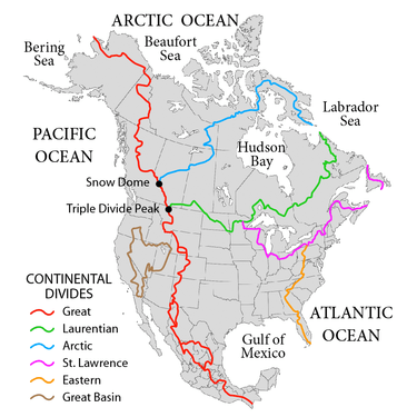
The term hydrological apex refers to a triple divide considered the dominant one of a whole continent, because its waters flow into three different oceans. Triple Divide Peak in Montana is considered the triple divide "hydrological apex" of North America, though Snow Dome on the Alberta-British Columbia border also has a claim depending on how the Arctic and Atlantic oceans are defined. North America is the only continent, excluding the Antarctica ice fields, that has a triple point dividing basins draining into three different oceans.[1]
North America
North America has 3 triple divides in the United States which are intersections of continental divides, and a fourth one in British Columbia. Waters at these triple divides flow into three different oceans, seas or gulfs.
- Triple Divide Peak, Montana (Columbia, Mississippi, Nelson) is the intersection of the Continental Divide of the Americas and the Laurentian Divide.
- An unnamed hill in north-central Potter County, Pennsylvania (Allegheny River, Susquehanna River, Genesee River) is the intersection of the Eastern Continental Divide and Saint Lawrence River Divide.
- Hill of Three Waters, approx. 2 miles north of Hibbing, Minnesota (Big Fork & Red, St. Louis, Mississippi) is the intersection of the Saint Lawrence River Divide and Laurentian Divide.
- Snow Dome, British Columbia (Columbia, Mackenzie, Nelson) is the intersection of the Continental Divide and Arctic Divide.
The Eastern Continental Divide terminates in the south in a triple divide:
- Eastern divide/Kissimmee watershed, Florida (Miami, Withlacoochee, Kissimmee) is the intersection of the divide and the endorheic basin of Lake Okeechobee.
Where the Continental Divide splits and joins to form the boundary of the Great Divide Basin, it forms two triple points:
- Great Divide Basin (north): To the west of the basin is the Green River watershed, draining to the Gulf of California/Pacific Ocean; to the east is the North Platte watershed, draining to the Gulf of Mexico/Atlantic Ocean.
- Great Divide Basin (south): Where the Continental Divide splits in New Mexico and joins in Chihuahua, Mexico, to form the boundary of Guzman Basin, are two triple points:
- Reeds Point, New Mexico (Colorado, Rio Grande, Guzman Basin)
- Chihuahua rim, Chihuahua, Mexico
If the Gulf of California is considered distinct from the Pacific Coastal watershed, the divide between the Colorado River basin and Pacific basin forms two triple points:
- Three Waters Mountain, Wyoming (Colorado, Columbia, Mississippi)
- Commissary Ridge triple divide, Wyoming (Colorado, Columbia, Great Basin)
Other points are often considered to be triple divides because they separate basins of continental rivers.
- Headwaters Hill in Saguache County, Colorado, near Chester (Arkansas River, Rio Grande River, Colorado River). This point has only a weak claim to being a continental triple divide because both the Rio Grande and Arkansas Rivers flow into the Gulf of Mexico.
The highest elevation (13,240') significant triple divide in the lower 48 states of the United States, located in Kings Canyon National Park in Fresno/Inyo counties, California, is a sub-peak of Mount Wallace of the central Sierra Nevadas:
- Crumbly Spire or Mount Wallace South Peak, Fresno/Inyo counties, California (South Fork San Joaquin River, San Joaquin River, Owens River)
Numerous other triple divide points result from intersection of river basin divides:
- Young Lick Knob, Georgia (Savannah, Apalachicola, Mississippi)
Europe
- Witenwasserenstock: (Po, Rhine, Rhône)
- Lunghin Pass/Piz Lunghin: (Danube, Po, Rhine)
- Langres Plateau (exact point is 47°56'29.2"N 5°30'17.2"E or 47.941432N, 5.504649E): (Meuse-Rhine to North Sea, Seine to the Channel, Tille-Saône-Rhône to Mediterranean Sea)
See also
References
- "Ocean Triple Divide Points". Peakbagger.com. Retrieved 2017-07-01.(dead link)
- Joseph A. DiPietro (2012-12-21). Landscape Evolution in the United States: An Introduction to the Geography, Geology, and Natural History. Newnes.