Saint-Mandé
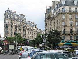
Saint-Mandé (French: [sɛ̃.mɑ̃.de]) is a high-end commune of the Val-de-Marne department in Île-de-France in the eastern suburbs of Paris, France. It is located 5.3 km (3.3 mi) from the center of Paris. It is one of the smallest communes of the Île-de-France by land area, but is one of the most densely populated municipalities in Europe. It is located on the edge of the 12th arrondissement of Paris, near the Porte de Vincennes and the Porte de Saint-Mandé. The motto of the city is Cresco et Floresco, which means "I grow and I flourish".
Saint-Mandé | |
|---|---|
 | |
 Coat of arms | |
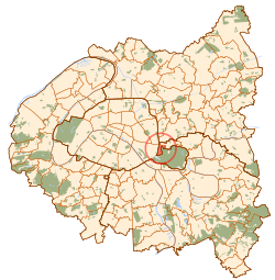 Paris and inner ring départements | |
Location of Saint-Mandé 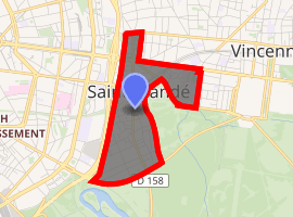
| |
 Saint-Mandé Paris and inner ring départements  Saint-Mandé Saint-Mandé (Île-de-France (region)) | |
| Coordinates: 48°50′32″N 2°25′07″E | |
| Country | France |
| Region | Île-de-France |
| Department | Val-de-Marne |
| Arrondissement | Nogent-sur-Marne |
| Canton | Vincennes |
| Intercommunality | Grand Paris |
| Government | |
| • Mayor | Patrick Beaudouin |
| Area 1 | 0.92 km2 (0.36 sq mi) |
| Population (2017-01-01)[1] | 22,619 |
| • Density | 25,000/km2 (64,000/sq mi) |
| Time zone | UTC+01:00 (CET) |
| • Summer (DST) | UTC+02:00 (CEST) |
| INSEE/Postal code | 94067 /94160 |
| Elevation | 42–54 m (138–177 ft) |
| 1 French Land Register data, which excludes lakes, ponds, glaciers > 1 km2 (0.386 sq mi or 247 acres) and river estuaries. | |
History
On 1 January 1860, the city of Paris was enlarged by annexing neighboring communes. On that occasion, about two-thirds of the commune of Saint-Mandé was annexed to Paris, and now forms the neighborhoods of Bel-Air and Picpus, in the 12th arrondissement of Paris.
In 1929, the commune of Saint-Mandé lost one-quarter of its territory when the city of Paris annexed the Bois de Vincennes, a small part of which belonged to Saint-Mandé, leaving Saint-Mandé as a small rump commune after the territorial losses of 1860 and 1929.
Personalities
- Juliette Benzoni, novel writer
- Charles Berling, actor
- Maurice Boitel, painter
- Armand Carrel, political writer, who died there in a duel
- Gaëtan Charbonnier, footballer
- Claudette Colbert, actress
- Georges Courteline writer and lampoonist
- Bruno Cremer, actor
- Alexandra David-Néel, Asian scholar
- Frédéric Diefenthal, actor
- Juliette Drouet, mistress of Victor Hugo
- Alfred Grévin, caricaturist, founder of Musée Grévin
- Jacqueline Lamba Breton, (1910–1993) was a French painter and married (1934–1943) to André Breton[2]
- Paul Nicolas, footballer
- Christine Nougaret, archivist
- Charles Nungesser, aviator
Transport
The municipality is crossed by a principal north–south axis, the Avenue du Général-de-Gaulle (formerly Rue de la République), and by an east–west axis, the Avenue de Paris (RN 34). Another important and historical street of the municipality is the Chaussée de l'Étang which goes along the Bois de Vincennes. Saint-Mandé is served by Saint-Mandé station on Paris Métro Line 1, as well as line no 8. RATP buses include lines 46, 56, 86 and 325. The closest airport is Roissy Charles-de-Gaulle, located around 24 km (15 mi).
Education
Schools include:[3]
- Preschools/nurseries (maternelles): Paul Bert, Charles Digeon, La Tourelle, E.G. Tillion preschool
- Elementary schools: Paul Bert, Charles Digeon, E.G. Tillion elementary
Junior high school students are served by Ecole & Collège Decroly,[4] and Collège Jacques Offenbach.[5]
The private school system Ensemble Scolaire St Michel de Picpus maintains a secondary campus in Saint-Mandé.[6]
Twin towns
Saint-Mandé is twinned with:


References
- "Populations légales 2017". INSEE. Retrieved 6 January 2020.
- "Jacqueline Lamba Breton Biography (1910–1993)". leninimports.com.
- "Les écoles." Saint-Mandé. Retrieved on September 11, 2016.
- Home. Ecole & Collège Decroly. Retrieved on September 11, 2016.
- Home. Collège Jacques Offenbach. Retrieved on September 11, 2016.
- Home. Ensemble Scolaire St Michel de Picpus. Retrieved on September 11, 2016.
External links
- Official website (in French)
| Wikimedia Commons has media related to Saint-Mandé. |
| Authority control |
|
|---|