Saint-Mammès
Saint-Mammès is a commune in the Seine-et-Marne department in the Île-de-France region in north-central France, in the metropolitan area of Paris. It is located 61 kilometres (38 mi) south-southeast of the centre of Paris.It is situated at the confluence of the Seine and the Loing rivers. The Seine borders the northern boundaries of the city, while the Loing borders on the west.
Saint-Mammès | |
|---|---|
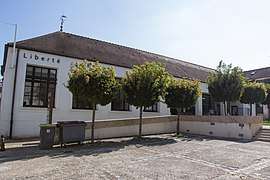 The town hall in Saint-Mammès | |
Location of Saint-Mammès 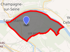
| |
 Saint-Mammès  Saint-Mammès | |
| Coordinates: 48°23′21″N 2°48′29″E | |
| Country | France |
| Region | Île-de-France |
| Department | Seine-et-Marne |
| Arrondissement | Fontainebleau |
| Canton | Montereau-Fault-Yonne |
| Intercommunality | Moret Seine et Loing |
| Government | |
| • Mayor (2008–2014) | Yves Brument |
| Area 1 | 2.24 km2 (0.86 sq mi) |
| Population (2017-01-01)[1] | 3,347 |
| • Density | 1,500/km2 (3,900/sq mi) |
| Time zone | UTC+01:00 (CET) |
| • Summer (DST) | UTC+02:00 (CEST) |
| INSEE/Postal code | 77419 /77670 |
| Elevation | 42–87 m (138–285 ft) |
| 1 French Land Register data, which excludes lakes, ponds, glaciers > 1 km2 (0.386 sq mi or 247 acres) and river estuaries. | |
Demographics
Inhabitants of Saint-Mammès are called Mammèsiens. In 2009, there were 3284 inhabitants.
Climate and geology
Like the rest of Ile de France, Saint Mammès has an oceanic climate. The oceanic temperatures extend into the mainland and result in an average temperature of 64 °F in the summer and 43 °F in the winter, with frequent rain during all seasons and varying temperatures but with weaker rains than the coasts, as well as some points of influence from continental weather at the height of the seasons.
The borders of the community span about 603 acres; the altitude varies between 42 and 87 meters.[2]
Transport
Saint-Mammès is served by one station on the Transilien Paris-Lyon rail line that ends at Montereau via the Moret-Veneux-les-Sablons station in Zone 5 for Navigo cards.[3]
The city is also served by the Comète bus (lines 3-6-8) that is mainly used by students who live in the nearby communities.
Urban planning
It is predominantly suburban housing, the town having few larger sets. The type of habitation varies between the different quarters. The city center is characterized by small homes with no more than two floors, situated close together and framed by small streets.
The commercial and business zones are, for the most part, concentrated near the docks of the Seine.
The city does not have officially designated zones.[4] Nevertheless you can distinguish some areas: the place of the Bulge and the Seine in the northwest, the Palottes in the west, the Guettes and Berville residences, situated respectively in the outskirts of the city and next to the train station, the Trop Chères area in the north, the city center, and the commercial zones as well as the suburban districts like the Sablonnières, Monthièvres, Roberies, Longues Raies, and Fonds.
Representation in art
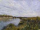 View of Saint-Mammès, Alfred Sisley. The Walters Art Museum.
References
- "Populations légales 2017". INSEE. Retrieved 6 January 2020.
- Répertoire géographique des communes Archived 2015-01-08 at the Wayback Machine, publié par l'Institut national de l'information géographique et forestière
- Plan régional des transports en Île-de-France
- Consulté en juin 2011 Plan de Saint-Mammès Archived 2007-10-12 at the Wayback Machine
External links
| Wikimedia Commons has media related to Saint-Mammès. |
- 1999 Land Use, from IAURIF (Institute for Urban Planning and Development of the Paris-Île-de-France région) (in English)
- French Ministry of Culture list for Saint-Mammès (in French)
- Discover St Mammès, Official site of St Mammès (in English)
| Authority control |
|
|---|