Crécy-la-Chapelle
Crécy-la-Chapelle is a commune in the Seine-et-Marne department in the Île-de-France region in north-central France.
Crécy-la-Chapelle | |
|---|---|
 The town hall in Crécy-la-Chapelle | |
.svg.png) Coat of arms | |
Location of Crécy-la-Chapelle 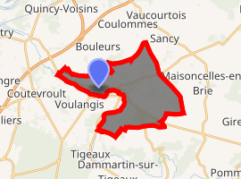
| |
 Crécy-la-Chapelle  Crécy-la-Chapelle | |
| Coordinates: 48°51′23″N 2°54′40″E | |
| Country | France |
| Region | Île-de-France |
| Department | Seine-et-Marne |
| Arrondissement | Meaux |
| Canton | Serris |
| Intercommunality | CA Coulommiers Pays de Brie |
| Government | |
| • Mayor (2015–2020) | Bernard Carouge |
| Area 1 | 15.78 km2 (6.09 sq mi) |
| Population (2017-01-01)[1] | 4,531 |
| • Density | 290/km2 (740/sq mi) |
| Time zone | UTC+01:00 (CET) |
| • Summer (DST) | UTC+02:00 (CEST) |
| INSEE/Postal code | 77142 /77580 |
| Elevation | 45–157 m (148–515 ft) |
| 1 French Land Register data, which excludes lakes, ponds, glaciers > 1 km2 (0.386 sq mi or 247 acres) and river estuaries. | |
Geography
Situation
Crécy-la-Chapelle is crossed by the river Grand Morin. The ground of the area is limestone.
Others localities
Crécy Bourg, Montbarbin, Serbonne, la Chapelle-sur-Crécy, Libernon, Mongrolle, Férolles, Montaudier, la Grand-Cour, les Hauts-Soleil, le Choisiel, le Souterain, Montpichet
Demographics
The inhabitants are called Créçois.
Politics and administration
The town is twinned with
Pielenhofen ![]()
Local culture and heritage
_Coll%C3%A9giale_Tympan.jpg)
Tympanum on the occidental portal of the collegiate.
Spots and monuments
- Collegiate Notre-Dame de Crécy-la-Chapelle,[2] classified monument historique since 1846.[3]
- Saint-Georges church.
- Beffroi.
- Quai des Tanneries.
- Tour aux Saints.
- War memorial for WW1 (Edme Marie Cadoux).
- The local museum is Musée de France, au sens de la loi No. 2002-5 du 4 January 2002 ; It is closed now (January 2013).
 House where lived the artist Corot.
 Wall walk.
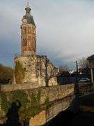 Belfry dating from the 19th century built on a tower dating from 12th century.
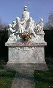 War memorial.
 Vestige of the delivery service.
References
- "Populations légales 2017". INSEE. Retrieved 6 January 2020.
- La collégiale Notre-Dame-de-l’Assomption Archived 2016-12-03 at the Wayback Machine on the official website of the cityhall. Consulté le 10 octobre 2011.
- Mérimée PA00086915, Ministère français de la Culture. (in French)
External links
| Wikimedia Commons has media related to Crécy-la-Chapelle. |
- 1999 Land Use, from IAURIF (Institute for Urban Planning and Development of the Paris-Île-de-France région) (in English)
- French Ministry of Culture list for Crécy-la-Chapelle (in French)
- Official website of the city (in French)
| Authority control |
|
|---|
This article is issued from Wikipedia. The text is licensed under Creative Commons - Attribution - Sharealike. Additional terms may apply for the media files.