Saint-James
Saint-James (French pronunciation: [sɛ̃ʒɑm]) is a commune in the Manche department in Normandy in north-western France. On 1 January 2017, the former communes of Argouges, Carnet, La Croix-Avranchin, Montanel, Vergoncey and Villiers-le-Pré were merged into Saint-James.[1]
Saint-James | |
|---|---|
 The church of Saint-Jacques | |
Location of Saint-James 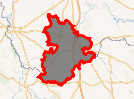
| |
 Saint-James  Saint-James | |
| Coordinates: 48°31′25″N 1°19′24″W | |
| Country | France |
| Region | Normandy |
| Department | Manche |
| Arrondissement | Avranches |
| Canton | Saint-Hilaire-du-Harcouët |
| Intercommunality | Mont-Saint-Michel-Normandie |
| Government | |
| • Mayor (2017–2020) | Carine Mahieu |
| Area 1 | 86.41 km2 (33.36 sq mi) |
| Population (2014) | 5,070 |
| • Density | 59/km2 (150/sq mi) |
| Time zone | UTC+01:00 (CET) |
| • Summer (DST) | UTC+02:00 (CEST) |
| INSEE/Postal code | 50487 /50240 |
| Elevation | 28–151 m (92–495 ft) (avg. 110 m or 360 ft) |
| 1 French Land Register data, which excludes lakes, ponds, glaciers > 1 km2 (0.386 sq mi or 247 acres) and river estuaries. | |
Geography
Saint-James is on the border between Normandy and Brittany. The rivers Beuvron and Dierge flow through the commune.
History
William the Conqueror built the Saint-James fortress in 1067.
Heraldry
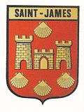 Arms of Saint-James |
The arms of Saint-James are blazoned : Gules, a gate argent flanked by 2 towers the sinister one taller Or, all masoned sable, in chief 1 escallop and in base 3 escallops argent. |
International relations
Saint-James is twinned with:
Demographics
| Year | 1962 | 1968 | 1975 | 1982 | 1990 | 1999 |
|---|---|---|---|---|---|---|
| Population | 2415 | 2452 | 2489 | 2766 | 2976 | 2917 |
| From the year 1962 on: No double counting—residents of multiple communes (e.g. students and military personnel) are counted only once. | ||||||
Places of interest
World War II
After the liberation of the area by Allied Forces in 1944, engineers of the Ninth Air Force IX Engineering Command began construction of a combat Advanced Landing Ground outside of the town. Declared operational on 14 August, the airfield was designated as "A-29", it was used by the 373d Fighter Group which flew P-47 Thunderbolts until early September when the unit moved into Central France. Afterward, the airfield was closed.[6][7]
See also
References
- Arrêté préfectoral 8 July 2016 (in French)
- "British towns twinned with French towns [via WaybackMachine.com]". Archant Community Media Ltd. Archived from the original on 5 July 2013. Retrieved 2013-07-20.
- "Beaminster twinned with Saint-James". Beaminster Community.net. Retrieved 2013-07-29.
- Thoury, Michel. "31 ème anniversaire du Jumelage à Beaminster". Site de L'Office de Tourisme Saint James (in French). Archived from the original on 2013-07-29. Retrieved 2013-07-29.
- "Dorset Twinning Association List". The Dorset Twinning Association. Archived from the original on 2012-06-21. Retrieved 2013-08-01.
- Johnson, David C. (1988), U.S. Army Air Forces Continental Airfields (ETO), D-Day to V-E Day; Research Division, USAF Historical Research Center, Maxwell AFB, Alabama.
- Maurer, Maurer. Air Force Combat Units of World War II. Maxwell AFB, Alabama: Office of Air Force History, 1983. ISBN 0-89201-092-4.
| Wikimedia Commons has media related to Saint-James. |