Saint-Hilaire-du-Harcouët
Saint-Hilaire-du-Harcouët is a commune in the Manche department in Normandy in north-western France. On 1 January 2016, the former communes of Saint-Martin-de-Landelles and Virey were merged into Saint-Hilaire-du-Harcouët.[2]
Saint-Hilaire-du-Harcouët | |
|---|---|
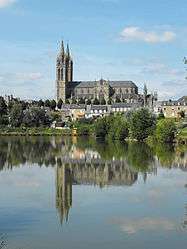 The church of Saint-Hilaire | |
Location of Saint-Hilaire-du-Harcouët 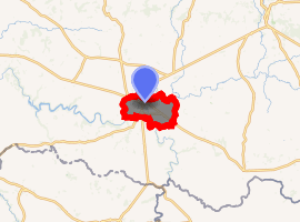
| |
 Saint-Hilaire-du-Harcouët  Saint-Hilaire-du-Harcouët | |
| Coordinates: 48°34′42″N 1°05′27″W | |
| Country | France |
| Region | Normandy |
| Department | Manche |
| Arrondissement | Avranches |
| Canton | Saint-Hilaire-du-Harcouët |
| Intercommunality | Mont-Saint-Michel-Normandie |
| Government | |
| • Mayor (2008–2014) | Gilbert Badiou |
| Area 1 | 46.97 km2 (18.14 sq mi) |
| Population (2017-01-01)[1] | 3,912 |
| • Density | 83/km2 (220/sq mi) |
| Time zone | UTC+01:00 (CET) |
| • Summer (DST) | UTC+02:00 (CEST) |
| INSEE/Postal code | 50484 /50600 |
| Elevation | 58–119 m (190–390 ft) (avg. 19 m or 62 ft) |
| 1 French Land Register data, which excludes lakes, ponds, glaciers > 1 km2 (0.386 sq mi or 247 acres) and river estuaries. | |
It is approximately 50 miles (80 km) east of St. Malo and a similar distance northeast of Rennes. A medieval tower in the town centre, the only remainder of the old church, contains frescos by painter Marthe Flandrin.[3]
Heraldry
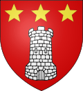 Arms of Saint-Hilaire-du-Harcouët |
The arms of Saint-Hilaire-du-Harcouët are blazoned : Gules, a tower argent, and in chief 3 mullets Or. |
See also
References
- "Populations légales 2017". INSEE. Retrieved 6 January 2020.
- Arrêté préfectoral 15 December 2015 (in French)
- normandythenandnow.com, Details and photos
| Wikimedia Commons has media related to Saint-Hilaire-du-Harcouët. |
| Authority control |
|
|---|
This article is issued from Wikipedia. The text is licensed under Creative Commons - Attribution - Sharealike. Additional terms may apply for the media files.