Saint-Fiacre-sur-Maine
Saint-Fiacre-sur-Maine is a commune in the Loire-Atlantique département in western France.
Saint-Fiacre-sur-Maine | |
|---|---|
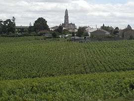 A general view of Saint-Fiacre-sur-Maine | |
.svg.png) Coat of arms | |
Location of Saint-Fiacre-sur-Maine 
| |
 Saint-Fiacre-sur-Maine 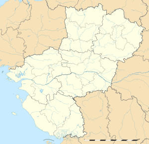 Saint-Fiacre-sur-Maine | |
| Coordinates: 47°08′39″N 1°24′56″W | |
| Country | France |
| Region | Pays de la Loire |
| Department | Loire-Atlantique |
| Arrondissement | Nantes |
| Canton | Vertou |
| Intercommunality | Sèvre, Maine et Goulaine |
| Government | |
| • Mayor (2008–2014) | Jean-Yves Lecoq |
| Area 1 | 5.97 km2 (2.31 sq mi) |
| Population (2017-01-01)[1] | 1,207 |
| • Density | 200/km2 (520/sq mi) |
| Time zone | UTC+01:00 (CET) |
| • Summer (DST) | UTC+02:00 (CEST) |
| INSEE/Postal code | 44159 /44690 |
| Elevation | 2–53 m (6.6–173.9 ft) (avg. 53 m or 174 ft) |
| 1 French Land Register data, which excludes lakes, ponds, glaciers > 1 km2 (0.386 sq mi or 247 acres) and river estuaries. | |
The inhabitants are Fiacrais.
Situated near Nantes, Saint-Fiacre is surrounded by Muscadet vineyards, between Sèvre Nantaise and Maine rivers.
Geography

Saint-Fiacre-Sur-Maine in Loire-Atlantique
- More of 80% of this commune is covered in vines, more than any other in France. There are more than 30 vine growers.
- The communes bordering Saint-Fiacre-sur-Maine are: Vertou, La Haie-Fouassière, Château-Thébaud and Maisdon-sur-Sèvre.
History
Saint-Hilaire-du-Coing (Sanctus Hilarius del Cugno), was founded in the 6th century, becoming Saint-Fiacre-du-Coing (and Saint-Fiacre) in the 16th century because of pilgrimages to view the saint's statue.
Twin towns
Saint Fiacre sur Maine has a town twinning agreement with

Demographics
| Year | 1962 | 1968 | 1975 | 1982 | 1990 | 1999 | 2007 |
|---|---|---|---|---|---|---|---|
| Population | 636 | 651 | 761 | 935 | 935 | 996 | 1147 |
External links
| Wikimedia Commons has media related to Saint-Fiacre-sur-Maine. |
| Authority control |
|
|---|
This article is issued from Wikipedia. The text is licensed under Creative Commons - Attribution - Sharealike. Additional terms may apply for the media files.