Pornichet
Pornichet (French pronunciation: [pɔʁniʃɛ]; Breton: Pornizhan) is a commune in the Loire-Atlantique department in western France.
Pornichet | |
|---|---|
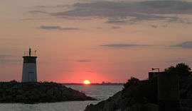 Sunset at the entrance to the port of Pornichet | |
.svg.png) Coat of arms | |
Location of Pornichet 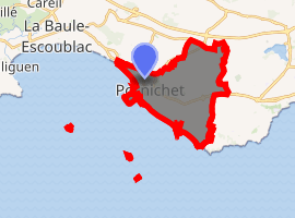
| |
 Pornichet  Pornichet | |
| Coordinates: 47°16′39″N 2°20′20″W | |
| Country | France |
| Region | Pays de la Loire |
| Department | Loire-Atlantique |
| Arrondissement | Saint-Nazaire |
| Canton | La Baule-Escoublac |
| Intercommunality | région nazairienne et l'estuaire |
| Government | |
| • Mayor (2014–2020) | Jean-Claude Pelleteur |
| Area 1 | 12.67 km2 (4.89 sq mi) |
| Population (2017-01-01)[1] | 10,669 |
| • Density | 840/km2 (2,200/sq mi) |
| Demonym(s) | Pornichétines, Pornichétins |
| Time zone | UTC+01:00 (CET) |
| • Summer (DST) | UTC+02:00 (CEST) |
| INSEE/Postal code | 44132 /44380 |
| Elevation | 0–44 m (0–144 ft) |
| Website | http://www.mairie-pornichet.fr/ |
| 1 French Land Register data, which excludes lakes, ponds, glaciers > 1 km2 (0.386 sq mi or 247 acres) and river estuaries. | |
Geography
Location
Pornichet is a coastal town of the Côte d'Amour, located tens of kilometers west of Saint-Nazaire.
The adjacent towns are Saint-Nazaire and La Baule-Escoublac.
Physical geography
The town of Pornichet is located
- on the line sillon de Guérande, orientated NW-SE; the town border is located on the Route de Guérande, D392d, at approximately 4 km from the shore, at a place called Pont de Terre (railway junction) at the Quatre Vents;
- on a coastal rock belt located upfront of the sillon de Guérande (same orientation), between two rock heads, the Pointe du Bec and the Pointe de la Lande (border with Saint-Nazaire), separated of 4.25 km;
- on sandy terranes part of the sand dune unit of Escoublac, between the place named Mazy (border with La Baule-Escoublac) and the Pointe du Bec (length: 2 km; width: 100 m at Mazy, 1 km at the head);
- on former swamp area (racetrack).
The lowest altitude (except shoreline) is of 4 m at the racetrack. The dune behind the beach of the Libraires reaches 9 m. The cliffs of Bonne Source and Sainte-Marguerite can reach 12 m. Going inland, altitudes progressively increase up to 44 m. The highest point is located in the hamlet called Ville ès Blais.
Shore and beaches
Pornichet has three beaches: in the West, the Beach of the Libraires (plage des Libraires), of 2 km length, is part of the Bay of Pouliguen (baie du Pouliguen), shared with La Baule; the border is marked by the Mazy creek (currently underground). In the East, between the Pointe du Bec and the Pointe de la Lande, are located the beaches of Bonne-Source (2.5 km) and Sainte-Marguerite (1.5 km), separated by a rocky head called the Pointe de Congrigoux.
Toponymy
The name of Pornichet comes from Port Niché, which could be translated by Port in a nivek. The town is named following its principal characteristic of a port located in an alcove along a salt-work channel, which was connecting the salt-works (current racetrack) and the bay.
History
Until the town was created in 1900, Pornichet was a hamlet of Saint-Nazaire.
Sister cities
See also
- Communes of the Loire-Atlantique department
- La Baule - Guérande Peninsula
- Parc naturel régional de Brière
| Wikimedia Commons has media related to Pornichet. |
| Authority control |
|
|---|
- "Populations légales 2017". INSEE. Retrieved 6 January 2020.